FAA INFORMATION EFFECTIVE 18 APRIL 2024
Location
| FAA Identifier: | 02A |
| Lat/Long: | 32-51-01.7441N 086-36-41.1569W
32-51.029068N 086-36.685948W
32.8504845,-86.6114325
(estimated) |
| Elevation: | 584.7 ft. / 178.2 m (surveyed) |
| Variation: | 04W (2020) |
| From city: | 1 mile E of CLANTON, AL |
| Time zone: | UTC -5 (UTC -6 during Standard Time) |
| Zip code: | 35045 |
Airport Operations
| Airport use: | Open to the public |
| Activation date: | 03/1940 |
| Control tower: | no |
| ARTCC: | ATLANTA CENTER |
| FSS: | ANNISTON FLIGHT SERVICE STATION |
| NOTAMs facility: | ANB (NOTAM-D service available) |
| Attendance: | MON-FRI 0800-1700
AFT HRS 205-755-8913 |
| Wind indicator: | lighted |
| Segmented circle: | yes |
| Lights: | ACTVT MIRL RWY 08/26 - CTAF. |
| Beacon: | white-green (lighted land airport)
Operates sunset to sunrise. |
Airport Communications
| CTAF/UNICOM: | 122.8 |
| MONTGOMERY APPROACH: | 121.2 |
| MONTGOMERY DEPARTURE: | 121.2 |
- APCH/DEP SVC PRVDD BY ATLANTA ARTCC ON FREQS 132.25/263.025 (UNIONTOWN RCAG) WHEN MONTGOMERY APCH CTL CLSD.
Nearby radio navigation aids
| VOR radial/distance | | VOR name | | Freq | | Var |
|---|
| OKWr126/39.6 | | BROOKWOOD VORTAC | | 111.00 | | 00E |
Airport Services
| Fuel available: | 100LL JET-A
100LL:SELF SERVE FUEL AVBL H24 N SIDE OF ARPT.
A:JET-A SELF SERVE NORTH SIDE OF FIELD 24/7. |
| Parking: | hangars and tiedowns |
| Airframe service: | MAJOR |
| Powerplant service: | MAJOR |
| Bottled oxygen: | NONE |
| Bulk oxygen: | NONE |
Runway Information
Runway 8/26
| Dimensions: | 4007 x 100 ft. / 1221 x 30 m |
| Surface: | asphalt, in good condition |
| Weight bearing capacity: | |
| Runway edge lights: | medium intensity |
| RUNWAY 8 | | RUNWAY 26 |
| Latitude: | 32-50.962385N | | 32-51.095750N |
| Longitude: | 086-37.069240W | | 086-36.302655W |
| Elevation: | 584.7 ft. | | 566.6 ft. |
| Traffic pattern: | left | | left |
| Runway heading: | 082 magnetic, 078 true | | 262 magnetic, 258 true |
| Markings: | nonprecision, in good condition | | nonprecision, in good condition |
| Visual slope indicator: | 2-light PAPI on left (4.00 degrees glide path) | | 2-light PAPI on left (4.00 degrees glide path) |
| Runway end identifier lights: | yes | | yes |
| Touchdown point: | yes, no lights | | yes, no lights |
| Obstructions: | 9 ft. tree, 301 ft. from runway, 155 ft. right of centerline, 11:1 slope to clear | | 35 ft. tree, 395 ft. from runway, 205 ft. right of centerline, 5:1 slope to clear |
Airport Ownership and Management from official FAA records
| Ownership: | Publicly-owned |
| Owner: | CHILTON COUNTY AIRPORT AUTHORITY
700 AIRPORT ROAD
CLANTON, AL 35045
Phone 205-280-3800 |
| Manager: | CHILTON COUNTY AIRPORT AUTHORITY
700 AIRPORT ROAD
CLANTON, AL 35045
Phone 205-280-3800 |
Airport Operational Statistics
| Aircraft based on the field: | | 22 | | Single engine airplanes: | | 19 | | Multi engine airplanes: | | 2 | | Helicopters: | | 1 |
| |  | |
| Aircraft operations: avg 66/day * | | 95% | transient general aviation | | 5% | local general aviation | | * for 12-month period ending 30 April 2019 | |
Additional Remarks
| - | FOR CD CTC MONTGOMERY APCH AT 334-284-4575, WHEN APCH CLSD FOR CD CTC ATLANTA ARTCC AT 770-210-7692. |
Instrument Procedures
NOTE: All procedures below are presented as PDF files. If you need a reader for these files, you should download the free Adobe Reader.NOT FOR NAVIGATION. Please procure official charts for flight.
FAA instrument procedures published for use from 18 April 2024 at 0901Z to 16 May 2024 at 0900Z.
IAPs - Instrument Approach Procedures |
|---|
| RNAV (GPS) RWY 08 | |
download (225KB) |
| RNAV (GPS) RWY 26 | |
download (221KB) |
| NOTE: Special Take-Off Minimums/Departure Procedures apply | |
download (302KB) |
Other nearby airports with instrument procedures:
KEET - Shelby County Airport (21 nm NW)
08A - Wetumpka Municipal Airport (24 nm SE)
KSCD - Merkel Field Sylacauga Municipal Airport (25 nm NE)
0A8 - Bibb County Airport (25 nm W)
1A9 - Prattville Airport - Grouby Field (25 nm S)
|
|

Road maps at:
MapQuest
Bing
Google
| Aerial photo |
|---|
WARNING: Photo may not be current or correct
 Photo by Gary Chambers
Photo taken 25-Feb-2005
looking west
Photo by Gary Chambers
Photo taken 25-Feb-2005
looking west
Do you have a better or more recent aerial photo of Chilton County Airport that you would like to share? If so, please send us your photo.
|
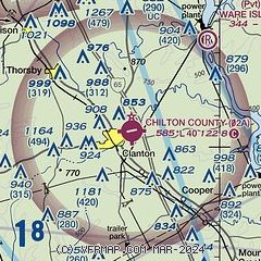
| Sectional chart |
|---|
|
| Airport distance calculator |
|---|
|
|
| Sunrise and sunset |
|---|
|
Times for 19-Apr-2024
| | Local
(UTC-5) | | Zulu
(UTC) |
|---|
| Morning civil twilight | | 05:46 | | 10:46 |
| Sunrise | | 06:12 | | 11:12 |
| Sunset | | 19:19 | | 00:19 |
| Evening civil twilight | | 19:45 | | 00:45 |
|
| Current date and time |
|---|
| Zulu (UTC) | 19-Apr-2024 23:26:17 |
|---|
| Local (UTC-5) | 19-Apr-2024 18:26:17 |
|---|
|
| METAR |
|---|
KEET
22nm NW | 192253Z AUTO 25003KT 10SM CLR 25/21 A3001 RMK AO2 SLP157 T02500206
|
KSCD
25nm NE | 192315Z AUTO 00000KT 10SM BKN110 25/20 A3002 RMK AO2 T02470202
|
K1A9
25nm S | 192315Z AUTO 00000KT 10SM CLR 28/17 A3000 RMK AO2 T02760173
|
KMXF
32nm SE | 192255Z AUTO 25004KT 10SM CLR 29/18 A2998 RMK AO2 SLP154 T02880182
|
KEKY
32nm NW | 192256Z AUTO VRB04KT 10SM CLR 26/21 A3003 RMK AO2 SLP016 T02610206
|
KALX
32nm E | 192315Z AUTO 33004KT 10SM CLR 26/19 A3001 RMK AO2 T02570191
|
KMGM
35nm S | 192253Z 22003KT 10SM BKN046 BKN060 29/18 A3000 RMK AO2 SLP156 T02890183
|
KSEM
36nm SW | 192310Z AUTO 29004KT 10SM SCT070 28/20 A3000 RMK AO2
|
|
| TAF |
|---|
KEET
22nm NW | 191722Z 1918/2018 VRB04KT P6SM OVC015 FM191900 25006KT P6SM BKN025 FM192100 26006KT P6SM VCSH BKN045 FM200300 VRB04KT P6SM OVC018 FM200600 VRB04KT 4SM BR OVC009 FM201400 01006KT P6SM OVC012
|
|
| NOTAMs |
|---|
NOTAMs are issued by the DoD/FAA and will open in a separate window not controlled by AirNav.
|
|


