FAA INFORMATION EFFECTIVE 18 APRIL 2024
Location
| FAA Identifier: | 0G6 |
| Lat/Long: | 41-28-02.3000N 084-30-24.4000W
41-28.038333N 084-30.406667W
41.4673056,-84.5067778
(estimated) |
| Elevation: | 729.6 ft. / 222.4 m (surveyed) |
| Variation: | 05W (2000) |
| From city: | 2 miles E of BRYAN, OH |
| Time zone: | UTC -4 (UTC -5 during Standard Time) |
| Zip code: | 43506 |
Airport Operations
| Airport use: | Open to the public |
| Activation date: | 01/1961 |
| Control tower: | no |
| ARTCC: | CLEVELAND CENTER |
| FSS: | CLEVELAND FLIGHT SERVICE STATION |
| NOTAMs facility: | CLE (NOTAM-D service available) |
| Attendance: | APR-NOV 0800-1830, DEC-MAR 0800-1730 |
| Wind indicator: | lighted |
| Segmented circle: | no |
| Lights: | ACTVT REIL RWY 07 & 25; MIRL RWY 07/25 - 123.0. |
| Beacon: | white-green (lighted land airport)
Operates sunset to sunrise. |
Airport Communications
| CTAF/UNICOM: | 122.8 |
| TOLEDO APPROACH: | 134.35 |
| TOLEDO DEPARTURE: | 134.35 |
| WX ASOS at DFI (9 nm SE): | 121.425 (419-658-2301) |
| WX AWOS-3P at USE (19 nm NE): | 127.375 (419-335-0775) |
Nearby radio navigation aids
| NDB name | | Hdg/Dist | | Freq | | Var | | ID |
|---|
| ADRIAN | | 225/30.9 | | 278 | | 06W | | ADG | .- -.. --. |
Airport Services
| Fuel available: | 100LL JET-A+ |
| Parking: | hangars and tiedowns |
| Airframe service: | MAJOR |
| Powerplant service: | MAJOR |
| Bottled oxygen: | LOW |
| Bulk oxygen: | NONE |
Runway Information
Runway 7/25
| Dimensions: | 4782 x 75 ft. / 1458 x 23 m |
| Surface: | asphalt/grooved, in good condition |
| Weight bearing capacity: | |
| Runway edge lights: | medium intensity |
| RUNWAY 7 | | RUNWAY 25 |
| Latitude: | 41-27.891640N | | 41-28.183662N |
| Longitude: | 084-30.892207W | | 084-29.919930W |
| Elevation: | 729.4 ft. | | 729.6 ft. |
| Traffic pattern: | left | | left |
| Runway heading: | 073 magnetic, 068 true | | 253 magnetic, 248 true |
| Displaced threshold: | 291 ft. | | 629 ft. |
| Markings: | nonprecision, in good condition | | nonprecision, in good condition |
| Visual slope indicator: | 4-light PAPI on left (3.00 degrees glide path) | | 4-light PAPI on left (3.00 degrees glide path) |
| Runway end identifier lights: | yes | | yes |
| Touchdown point: | yes, no lights | | yes, no lights |
| Obstructions: | 16 ft. road, 330 ft. from runway, 275 ft. left of centerline, 8:1 slope to clear
APCH SLP 20:1 TO DTHR OVR 40 FT LGTD POLE, 823 FT DIST, 254 FT R. | | 16 ft. road, 320 ft. from runway, 265 ft. right of centerline, 7:1 slope to clear
APCH SLP 16:1 TO DTHR OVR +77 FT TREE, 1291 FT DIST, 414 FT L. |
Airport Ownership and Management from official FAA records
| Ownership: | Publicly-owned |
| Owner: | WILLIAMS COUNTY COMMISSIONERS
1 COURTHOUSE SQ, 4TH FLR
BRYAN, OH 43506-1791
Phone 419-636-2059 |
| Manager: | STEVE FORTNER
16288 COUNTY ROAD D, HANGAR C
BRYAN, OH 43506-9802
Phone 419-630-4268
OR 567-239-6664. |
Airport Operational Statistics
| Aircraft based on the field: | | 23 | | Single engine airplanes: | | 20 | | Multi engine airplanes: | | 1 | | Jet airplanes: | | 2 |
| |  | |
| Aircraft operations: avg 24/day * | | 70% | local general aviation | | 30% | transient general aviation | | <1% | air taxi | | <1% | military | | * for 12-month period ending 03 October 2023 | |
Additional Remarks
| - | DEER, BIRDS, & WILDLIFE ON & INVOF ARPT. |
| - | FOR CD CTC TOLEDO APCH AT 419-865-1495. |
Instrument Procedures
NOTE: All procedures below are presented as PDF files. If you need a reader for these files, you should download the free Adobe Reader.NOT FOR NAVIGATION. Please procure official charts for flight.
FAA instrument procedures published for use from 18 April 2024 at 0901Z to 16 May 2024 at 0900Z.
IAPs - Instrument Approach Procedures |
|---|
| RNAV (GPS) RWY 07 | |
download (222KB) |
| RNAV (GPS) RWY 25 | |
download (211KB) |
| NOTE: Special Take-Off Minimums/Departure Procedures apply | |
download (164KB) |
Other nearby airports with instrument procedures:
KDFI - Defiance Memorial Airport (9 nm SE)
KUSE - Fulton County Airport (19 nm NE)
7W5 - Henry County Airport (21 nm E)
KGWB - De Kalb County Airport (27 nm W)
KJYM - Hillsdale Municipal Airport (27 nm N)
|
|

Road maps at:
MapQuest
Bing
Google
| Aerial photo |
|---|
WARNING: Photo may not be current or correct

Do you have a better or more recent aerial photo of Williams County Airport that you would like to share? If so, please send us your photo.
|
| Sectional chart |
|---|
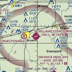
|
| Airport distance calculator |
|---|
|
|
| Sunrise and sunset |
|---|
|
Times for 18-Apr-2024
| | Local
(UTC-4) | | Zulu
(UTC) |
|---|
| Morning civil twilight | | 06:24 | | 10:24 |
| Sunrise | | 06:53 | | 10:53 |
| Sunset | | 20:21 | | 00:21 |
| Evening civil twilight | | 20:50 | | 00:50 |
|
| Current date and time |
|---|
| Zulu (UTC) | 18-Apr-2024 20:42:06 |
|---|
| Local (UTC-4) | 18-Apr-2024 16:42:06 |
|---|
|
| METAR |
|---|
KDFI
9nm S | 181953Z AUTO VRB04KT 10SM CLR 20/06 A3002 RMK AO2 SLP165 T02000061
|
KUSE
19nm NE | 182015Z AUTO 00000KT 10SM CLR 21/07 A3001 RMK AO2
|
|
| TAF |
|---|
KTOL
33nm E | 181740Z 1818/1918 27005KT P6SM SCT250 FM190000 12008KT P6SM BKN050 FM190500 17008KT 6SM -SHRA OVC025 WS020/20040KT FM190800 21012KT 6SM -SHRA OVC015 WS020/20040KT FM191000 29015G23KT P6SM VCSH OVC020 FM191400 30012KT P6SM FEW250
|
|
| NOTAMs |
|---|
NOTAMs are issued by the DoD/FAA and will open in a separate window not controlled by AirNav.
|
|

