FAA INFORMATION EFFECTIVE 18 APRIL 2024
Location
| FAA Identifier: | 28J |
| Lat/Long: | 29-39-30.1769N 081-41-22.2110W
29-39.502948N 081-41.370183W
29.6583825,-81.6895031
(estimated) |
| Elevation: | 47.8 ft. / 14.6 m (surveyed) |
| Variation: | 05W (2000) |
| From city: | 2 miles NW of PALATKA, FL |
| Time zone: | UTC -4 (UTC -5 during Standard Time) |
| Zip code: | 32177 |
Airport Operations
| Airport use: | Open to the public |
| Activation date: | 01/1943 |
| Control tower: | no |
| ARTCC: | JACKSONVILLE CENTER |
| FSS: | GAINESVILLE FLIGHT SERVICE STATION |
| NOTAMs facility: | GNV (NOTAM-D service available) |
| Attendance: | 0800-1800 |
| Wind indicator: | lighted |
| Segmented circle: | yes
WND CONE CIRCLED CONCRETE. |
| Lights: | ACTVT REIL RWY 09 & 27; PAPI RWY 09, 27, 17 & 35; MIRL RWY 09/27 & 17/35 - CTAF. |
| Beacon: | white-green (lighted land airport)
Operates sunset to sunrise. |
Airport Communications
| CTAF/UNICOM: | 122.8 |
| WX AWOS-3: | 119.925 (386-312-2212) |
| JACKSONVILLE APPROACH: | 118.175 ;10000 FT & BLW |
| JACKSONVILLE DEPARTURE: | 118.175 ;10000 FT & BLW |
Nearby radio navigation aids
| VOR radial/distance | | VOR name | | Freq | | Var |
|---|
| SGJr232/25.9 | | ST AUGUSTINE VOR/DME | | 109.40 | | 06W |
| GNVr098/30.5 | | GATORS VORTAC | | 116.20 | | 04W |
| OMNr305/36.9 | | ORMOND BEACH VORTAC | | 112.60 | | 00E |
| NDB name | | Hdg/Dist | | Freq | | Var | | ID |
|---|
| REYNOLDS | | 192/18.6 | | 338 | | 07W | | RYD | .-. -.-- -.. |
Airport Services
| Fuel available: | 100LL JET-A
100LL:CREDIT CARD FUEL AVBL 24 HRS. |
| Parking: | tiedowns |
| Airframe service: | MINOR |
| Powerplant service: | MAJOR |
| Bottled oxygen: | NONE |
| Bulk oxygen: | NONE |
Runway Information
Runway 9/27
| Dimensions: | 6000 x 100 ft. / 1829 x 30 m |
| Surface: | asphalt, in good condition |
| Weight bearing capacity: | | PCN 28 /F/A/X/T | | Single wheel: | 21.0 | | Double wheel: | 60.0 |
|
| Runway edge lights: | medium intensity |
| RUNWAY 9 | | RUNWAY 27 |
| Latitude: | 29-39.468815N | | 29-39.515340N |
| Longitude: | 081-41.999415W | | 081-40.867485W |
| Elevation: | 32.4 ft. | | 30.6 ft. |
| Traffic pattern: | left | | left |
| Runway heading: | 092 magnetic, 087 true | | 272 magnetic, 267 true |
| Displaced threshold: | no | | 449 ft. |
| Declared distances: | TORA:5549 TODA:5549 ASDA:5999 LDA:5999 | | TORA:5999 TODA:5999 ASDA:5999 LDA:5549 |
| Markings: | nonprecision, in fair condition | | nonprecision, in fair condition |
| Visual slope indicator: | 4-light PAPI on left (3.00 degrees glide path) | | 4-light PAPI on left (3.50 degrees glide path) |
| Runway end identifier lights: | yes | | yes |
| Touchdown point: | yes, no lights | | yes, no lights |
| Obstructions: | 26 ft. trees, marked and lighted, 1140 ft. from runway, 260 ft. left of centerline, 36:1 slope to clear | | 58 ft. trees, 1520 ft. from runway, 22:1 slope to clear
APCH SLP 34:1 TO DTHR. |
Runway 17/35
| Dimensions: | 3510 x 75 ft. / 1070 x 23 m |
| Surface: | asphalt, in good condition |
| Weight bearing capacity: | | PCN 22 /F/B/X/T | | Single wheel: | 31.0 | | Double wheel: | 60.0 |
|
| Runway edge lights: | medium intensity |
| Operational restrictions: | RSTRD TO ACFT 12500 LB GWT OR LESS. |
| RUNWAY 17 | | RUNWAY 35 |
| Latitude: | 29-39.717697N | | 29-39.157287N |
| Longitude: | 081-41.441448W | | 081-41.275172W |
| Elevation: | 28.8 ft. | | 47.8 ft. |
| Traffic pattern: | left | | left |
| Runway heading: | 170 magnetic, 165 true | | 350 magnetic, 345 true |
| Markings: | basic, in fair condition | | basic, in fair condition |
| Visual slope indicator: | 2-light PAPI on left (3.00 degrees glide path) | | 2-light PAPI on left (3.75 degrees glide path)
PAPI UNUSBL BYD 7 DEG LEFT OF CNTRLN. |
| Touchdown point: | yes, no lights | | yes, no lights |
| Obstructions: | 78 ft. trees, 1960 ft. from runway, 110 ft. left of centerline, 22:1 slope to clear | | 47 ft. trees, 955 ft. from runway, 95 ft. left of centerline, 16:1 slope to clear |
Airport Ownership and Management from official FAA records
| Ownership: | Publicly-owned |
| Owner: | CITY OF PALATKA
201 NORTH 2ND ST
PALATKA, FL 32177
Phone 386-329-0100
ARPT PHYS ADS: 4015 REID STREET; 386-329-0148. |
| Manager: | YUL MCNAIR
4015 REID ST, HWY 100
PALATKA, FL 32177
Phone 386-329-0148 |
Airport Operational Statistics
| Aircraft based on the field: | | 74 | | Single engine airplanes: | | 64 | | Multi engine airplanes: | | 9 | | Jet airplanes: | | 1 |
| |  | |
| Aircraft operations: avg 102/day * | | 91% | transient general aviation | | 7% | local general aviation | | 1% | military | | <1% | air taxi | | * for 12-month period ending 09 February 2018 | |
Additional Remarks
| A30A-35 | UNLGTD OBSTNS IN APCH; TREES 1520 FT BFR AER. |
| A30A-09 | PREFERRED RWY. |
| - | WILDLIFE ON & INVOF ARPT. |
| - | UNLGTD OBSTNS PRESENT IN THE APCH TO RWY 35 DUE TO TREES 1520 FT BFR AER RWY 35. |
Instrument Procedures
NOTE: All procedures below are presented as PDF files. If you need a reader for these files, you should download the free Adobe Reader.NOT FOR NAVIGATION. Please procure official charts for flight.
FAA instrument procedures published for use from 18 April 2024 at 0901Z to 16 May 2024 at 0900Z.
IAPs - Instrument Approach Procedures |
|---|
| RNAV (GPS) RWY 09 | |
download (307KB) |
| RNAV (GPS) RWY 27 | |
download (306KB) |
| NOTE: Special Alternate Minimums apply | |
download (124KB) |
| NOTE: Special Take-Off Minimums/Departure Procedures apply | |
download (411KB) |
Other nearby airports with instrument procedures:
42J - Keystone Heights Airport (22 nm NW)
KSGJ - Northeast Florida Regional Airport (26 nm NE)
KFIN - Flagler Executive Airport (28 nm SE)
KGNV - Gainesville Regional Airport (30 nm W)
KNIP - Jacksonville Naval Air Station (Towers Field) (35 nm N)
|
|

Road maps at:
MapQuest
Bing
Google
| Aerial photo |
|---|
WARNING: Photo may not be current or correct
 Photo by Paul Everitt
Photo taken 29-Oct-2005
from a Liberty XL2
Photo by Paul Everitt
Photo taken 29-Oct-2005
from a Liberty XL2
Do you have a better or more recent aerial photo of Palatka Municipal Airport - Lt. Kay Larkin Field that you would like to share? If so, please send us your photo.
|
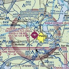
| Sectional chart |
|---|
|
| Airport distance calculator |
|---|
|
|
| Sunrise and sunset |
|---|
|
Times for 18-Apr-2024
| | Local
(UTC-4) | | Zulu
(UTC) |
|---|
| Morning civil twilight | | 06:32 | | 10:32 |
| Sunrise | | 06:57 | | 10:57 |
| Sunset | | 19:55 | | 23:55 |
| Evening civil twilight | | 20:20 | | 00:20 |
|
| Current date and time |
|---|
| Zulu (UTC) | 19-Apr-2024 00:44:41 |
|---|
| Local (UTC-4) | 18-Apr-2024 20:44:41 |
|---|
|
| METAR |
|---|
| K28J | 190035Z AUTO 06004KT 10SM OVC060 24/20 A3005 RMK AO2
|
|
| TAF |
|---|
KSGJ
27nm NE | 181720Z 1818/1918 12010KT P6SM FEW050 SCT250 FM190000 16008KT P6SM SCT250 FM190400 VRB04KT P6SM SCT250 FM191500 26006KT P6SM SCT250
|
KGNV
31nm W | 181720Z 1818/1918 23006KT P6SM FEW040 SCT150 BKN250 FM190300 VRB04KT P6SM SCT250
|
|
| NOTAMs |
|---|
NOTAMs are issued by the DoD/FAA and will open in a separate window not controlled by AirNav.
|
|


