FAA INFORMATION EFFECTIVE 18 APRIL 2024
Location
| FAA Identifier: | 2B7 |
| Lat/Long: | 44-46-06.7000N 069-22-27.9000W
44-46.111667N 069-22.465000W
44.7685278,-69.3744167
(estimated) |
| Elevation: | 197.1 ft. / 60.1 m (surveyed) |
| Variation: | 17W (2010) |
| From city: | 1 mile SE of PITTSFIELD, ME |
| Time zone: | UTC -4 (UTC -5 during Standard Time) |
| Zip code: | 04967 |
Airport Operations
| Airport use: | Open to the public |
| Activation date: | 02/1943 |
| Control tower: | no |
| ARTCC: | BOSTON CENTER |
| FSS: | BANGOR FLIGHT SERVICE STATION |
| NOTAMs facility: | BGR (NOTAM-D service available) |
| Attendance: | 0700-1700 |
| Wind indicator: | lighted |
| Segmented circle: | yes |
| Lights: | ACTVT REIL RWY 18 & 36; PAPI RWY 36; MIRL RWY 18/36 - CTAF. |
| Beacon: | white-green (lighted land airport)
Operates sunset to sunrise. |
Airport Communications
| CTAF/UNICOM: | 122.8 |
| BANGOR APPROACH: | 118.925 |
| BANGOR DEPARTURE: | 118.925 |
| WX AWOS-3PT at WVL (19 nm SW): | 118.375 (207-877-0519) |
Nearby radio navigation aids
| VOR radial/distance | | VOR name | | Freq | | Var |
|---|
| BGRr277/21.8 | | BANGOR VORTAC | | 114.80 | | 19W |
| AUGr052/32.4 | | AUGUSTA VOR/DME | | 114.95 | | 18W |
| NDB name | | Hdg/Dist | | Freq | | Var | | ID |
|---|
| BURNHAM | | 009/4.3 | | 348 | | 18W | | BUP | -... ..- .--. |
Airport Services
| Fuel available: | 100LL JET-A1+
100LL:100LL FUEL AFT HRS, CALL 207-232-2318. |
| Parking: | hangars and tiedowns |
| Airframe service: | MAJOR |
| Powerplant service: | MAJOR |
| Bottled oxygen: | NONE |
| Bulk oxygen: | NONE |
Runway Information
Runway 18/36
| Dimensions: | 4003 x 100 ft. / 1220 x 30 m |
| Surface: | asphalt, in good condition |
| Weight bearing capacity: | | Single wheel: | 38.0 | | Double wheel: | 49.0 |
|
| Runway edge lights: | medium intensity |
| Runway edge markings: | NRS AND CNTRLN FADED OR MISG. |
| RUNWAY 18 | | RUNWAY 36 |
| Latitude: | 44-46.433000N | | 44-45.790003N |
| Longitude: | 069-22.565818W | | 069-22.365125W |
| Elevation: | 197.1 ft. | | 176.3 ft. |
| Traffic pattern: | left | | left |
| Runway heading: | 184 magnetic, 167 true | | 004 magnetic, 347 true |
| Markings: | nonprecision, in poor condition | | nonprecision, in poor condition |
| Visual slope indicator: | | | 4-light PAPI on left (3.00 degrees glide path) |
| Runway end identifier lights: | yes | | yes |
| Touchdown point: | yes, no lights | | yes, no lights |
| Obstructions: | 40 ft. pole, 842 ft. from runway, 257 ft. left of centerline, 16:1 slope to clear
6-10 FT BRUSH, 0-200 FT FM THR, 225-250 FT L OF CNTRLN. | | 5 ft. brush, 249 ft. from runway, 181 ft. right of centerline, 9:1 slope to clear
20 FT TREES 0-50 FT FM THR, 210 FT L OF CNTRLN; 8 FT BRUSH 170-200 FT FM THR, 90 FT L OF CNTRLN. |
Airport Ownership and Management from official FAA records
| Ownership: | Publicly-owned |
| Owner: | TOWN OF PITTSFIELD
112 SOMERSET AVE
PITTSFIELD, ME 04967
Phone 207-487-3136 |
| Manager: | KATHRYN RUTH
112 SOMERSET AVE
PITTSFIELD, ME 04967
Phone 207-487-3136
TOWN MGR. |
Airport Operational Statistics
| Aircraft based on the field: | | 33 | | Single engine airplanes: | | 28 | | Multi engine airplanes: | | 5 |
| |  | |
| Aircraft operations: avg 44/day * | | 50% | local general aviation | | 31% | transient general aviation | | 19% | military | | <1% | air taxi | | * for 12-month period ending 23 August 2023 | |
Additional Remarks
| - | DEER AND TURKEYS INVOF ARPT. |
| - | FOR CD CTC BANGOR APCH AT 207-561-2500 EXT 1. |
Instrument Procedures
NOTE: All procedures below are presented as PDF files. If you need a reader for these files, you should download the free Adobe Reader.NOT FOR NAVIGATION. Please procure official charts for flight.
FAA instrument procedures published for use from 18 April 2024 at 0901Z to 16 May 2024 at 0900Z.
IAPs - Instrument Approach Procedures |
|---|
| RNAV (GPS) RWY 18 | |
download (210KB) |
| RNAV (GPS) RWY 36 | |
download (235KB) |
| NOTE: Special Take-Off Minimums/Departure Procedures apply | |
download (514KB) |
Other nearby airports with instrument procedures:
1B0 - Dexter Regional Airport (15 nm N)
KWVL - Waterville Robert LaFleur Airport (19 nm SW)
KOWK - Central Maine/Norridgewock Airport (21 nm W)
KBGR - Bangor International Airport (23 nm E)
KBST - Belfast Municipal Airport (27 nm SE)
|
|

Road maps at:
MapQuest
Bing
Google
| Aerial photo |
|---|
WARNING: Photo may not be current or correct
 Photo by Karen Frink, PE
Taken in the Fall of 2013
looking south.
Photo by Karen Frink, PE
Taken in the Fall of 2013
looking south.
Do you have a better or more recent aerial photo of Pittsfield Municipal Airport that you would like to share? If so, please send us your photo.
|
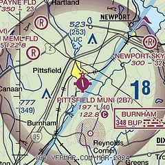
| Sectional chart |
|---|
|
| Airport distance calculator |
|---|
|
|
| Sunrise and sunset |
|---|
|
Times for 23-Apr-2024
| | Local
(UTC-4) | | Zulu
(UTC) |
|---|
| Morning civil twilight | | 05:08 | | 09:08 |
| Sunrise | | 05:39 | | 09:39 |
| Sunset | | 19:32 | | 23:32 |
| Evening civil twilight | | 20:04 | | 00:04 |
|
| Current date and time |
|---|
| Zulu (UTC) | 23-Apr-2024 16:16:09 |
|---|
| Local (UTC-4) | 23-Apr-2024 12:16:09 |
|---|
|
| METAR |
|---|
KWVL
20nm SW | 231556Z AUTO 20012G19KT 10SM CLR 13/M04 A3009 RMK AO2 SLP219 T01331039
|
KBGR
24nm E | 231553Z 19017G24KT 10SM CLR 12/M01 A3015 RMK AO2 SLP209 T01171011
|
KAUG
33nm SW | 231553Z AUTO 21010G23KT 10SM CLR 14/M04 A3013 RMK AO2 SLP205 T01391039
|
|
| TAF |
|---|
KBGR
24nm E | 231120Z 2312/2412 19007KT P6SM SKC FM231500 19011G22KT P6SM SKC FM240400 17005KT P6SM FEW100
|
|
| NOTAMs |
|---|
NOTAMs are issued by the DoD/FAA and will open in a separate window not controlled by AirNav.
|
|
