FAA INFORMATION EFFECTIVE 18 APRIL 2024
Location
| FAA Identifier: | 2D7 |
| Lat/Long: | 40-38-46.8650N 081-33-21.2400W
40-38.781083N 081-33.354000W
40.6463514,-81.5559000
(estimated) |
| Elevation: | 984 ft. / 299.9 m (surveyed) |
| Variation: | 06W (1985) |
| From city: | 1 mile E of BEACH CITY, OH |
| Time zone: | UTC -4 (UTC -5 during Standard Time) |
| Zip code: | 44608 |
Airport Operations
| Airport use: | Open to the public |
| Activation date: | 10/1955 |
| Control tower: | no |
| ARTCC: | CLEVELAND CENTER |
| FSS: | CLEVELAND FLIGHT SERVICE STATION |
| NOTAMs facility: | CLE (NOTAM-D service available) |
| Attendance: | UNATNDD |
| Pattern altitude: | 1800 ft. MSL |
| Wind indicator: | lighted |
| Segmented circle: | no |
| Lights: | ACTVT NSTD LIRL RWY 10/28 SS-SR - 122.85. |
| Beacon: | white-green (lighted land airport)
ACTVT ROTG BCN SS-SR - 122.85. |
Airport Communications
| CTAF/UNICOM: | 122.8 |
| CLEVELAND APPROACH: | 125.5 |
| CLEVELAND DEPARTURE: | 125.5 |
| WX ASOS at PHD (12 nm SE): | 121.425 (330-339-1125) |
| WX ASOS at CAK (17 nm N): | PHONE 330-493-5260 |
| WX AWOS-3 at 10G (19 nm W): | 128.325 (330-674-6279) |
- APCH/DEP SVC PRVDD BY CLEVELAND APCH (CLE) 0600-0100. APCH/DEP SVC PRVDD BY CLEVELAND ARTCC (ZOB) ON FREQS 120.6/379.275 (MOUNT HOPE RCAG) 0100-0600.
Nearby radio navigation aids
| VOR radial/distance | | VOR name | | Freq | | Var |
|---|
| BSVr229/8.0 | | BRIGGS VOR/DME | | 114.05 | | 04W |
| ACOr214/32.0 | | AKRON VOR/DME | | 114.40 | | 04W |
| NDB name | | Hdg/Dist | | Freq | | Var | | ID |
|---|
| CADIZ | | 322/34.9 | | 239 | | 07W | | CFX | -.-. ..-. -..- |
Airport Services
| Parking: | hangars and tiedowns |
| Airframe service: | NONE |
| Powerplant service: | NONE |
| Bottled oxygen: | NONE |
| Bulk oxygen: | NONE |
Runway Information
Runway 10/28
| Dimensions: | 3175 x 115 ft. / 968 x 35 m |
| Surface: | turf, in good condition |
| Runway edge lights: | non-standard
NSTD LIRL DUE TO LCTN ON YELLOW CONES & UNLGTD BFR EACH DTHR (2016 FT LGTD). |
| Runway edge markings: | 2016 FT MKD WITH LIRL ON YELLOW CONES; DTHR MKD WITH 1 GREEN LGT ON YELLOW CONE EACH SIDE; NO MKGS BFR EACH DTHR. |
| RUNWAY 10 | | RUNWAY 28 |
| Latitude: | 40-38.787000N | | 40-38.775167N |
| Longitude: | 081-33.697333W | | 081-33.010667W |
| Elevation: | 984.0 ft. | | 975.0 ft. |
| Traffic pattern: | left | | left |
| Runway heading: | 098 magnetic, 092 true | | 278 magnetic, 272 true |
| Displaced threshold: | 425 ft. | | 734 ft. |
| Markings: | , in good condition | | , in good condition |
| Visual slope indicator: | | | 2-box VASI on right (3.00 degrees glide path) |
| Runway end identifier lights: | no | | no |
| Touchdown point: | yes, no lights | | yes, no lights |
| Obstructions: | 35 ft. pline, 125 ft. right of centerline
APCH SLP 9:1 TO DTHR OVR +35 FT PLINE, 321 FT DIST, 157 FT L. | | 79 ft. trees, 389 ft. from runway, 4:1 slope to clear
APCH SLP 0:1 TO DTHR OVR +16 FT HNGR, 0 FT DIST, 110 FT L. |
Airport Ownership and Management from official FAA records
| Ownership: | Privately-owned |
| Owner: | BEACH CITY ARPT INC
PO BOX 82
NAVARRE, OH 44662-0082
Phone 330-236-5041 |
| Manager: | GARY SLUTZ
10431 DOLPHIN ST SW
BEACH CITY, OH 44608-9760
Phone 330-704-5686 |
Airport Operational Statistics
| Aircraft based on the field: | | 25 | | Single engine airplanes: | | 25 |
| |  | |
| Aircraft operations: avg 117/week * | | 66% | local general aviation | | 34% | transient general aviation | | * for 12-month period ending 26 September 2023 | |
Additional Remarks
| - | NO ULTRALIGHT ACFT WI 1 NMR. |
| - | ARPT CLSD TO MIL HELS. |
| - | FOR CD CTC CLEVELAND APCH AT 216-352-2323, WHEN APCH CLSD CTC CLEVELAND ARTCC AT 440-774-0223/0490. |
| - | DEER, BIRDS, & WILDLIFE ON & INVOF ARPT. |
| - | SEASONAL CROPS AT RWY EDGE, NORTH SIDE. |
Instrument Procedures
There are no published instrument procedures at 2D7.
Some nearby airports with instrument procedures:
KPHD - Harry Clever Field Airport (12 nm SE)
KCAK - Akron-Canton Regional Airport (17 nm N)
10G - Holmes County Airport (19 nm W)
KBJJ - Wayne County Airport (20 nm NW)
KTSO - Carroll County-Tolson Airport (22 nm E)
|
|

Road maps at:
MapQuest
Bing
Google
| Aerial photo |
|---|
WARNING: Photo may not be current or correct

Do you have a better or more recent aerial photo of Beach City Airport that you would like to share? If so, please send us your photo.
|
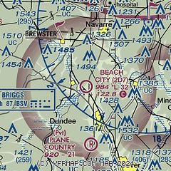
| Sectional chart |
|---|
|
| Airport distance calculator |
|---|
|
|
| Sunrise and sunset |
|---|
|
Times for 23-Apr-2024
| | Local
(UTC-4) | | Zulu
(UTC) |
|---|
| Morning civil twilight | | 06:06 | | 10:06 |
| Sunrise | | 06:35 | | 10:35 |
| Sunset | | 20:13 | | 00:13 |
| Evening civil twilight | | 20:43 | | 00:43 |
|
| Current date and time |
|---|
| Zulu (UTC) | 23-Apr-2024 22:30:05 |
|---|
| Local (UTC-4) | 23-Apr-2024 18:30:05 |
|---|
|
| METAR |
|---|
KPHD
13nm SE | 232153Z AUTO 23007KT 10SM OVC100 18/01 A2986 RMK AO2 SLP113 T01830011
|
KCAK
17nm N | 232151Z 32005KT 10SM FEW065 BKN120 OVC150 14/05 A2986 RMK AO2 SLP115 T01390050
|
KBJJ
20nm NW | 232156Z AUTO 00000KT 10SM SCT070 OVC100 16/05 A2986 RMK AO2 SLP113 T01610050
|
KAKR
24nm N | 232154Z AUTO 25004KT 10SM OVC100 14/04 A2985 RMK AO2 SLP110 T01390044
|
|
| TAF |
|---|
KCAK
17nm N | 231742Z 2318/2418 22018G28KT P6SM OVC250 FM232300 24009KT 6SM -SHRA BR OVC035 TEMPO 2402/2404 3SM -SHRA BKN025 FM240500 24010KT P6SM OVC015 FM241100 28007KT P6SM OVC008 FM241500 33012G20KT P6SM OVC008
|
|
| NOTAMs |
|---|
NOTAMs are issued by the DoD/FAA and will open in a separate window not controlled by AirNav.
|
|

