FAA INFORMATION EFFECTIVE 18 APRIL 2024
Location
| FAA Identifier: | 35C |
| Lat/Long: | 43-07-43.0800N 085-30-18.6700W
43-07.718000N 085-30.311167W
43.1286333,-85.5051861
(estimated) |
| Elevation: | 890 ft. / 271 m (estimated) |
| Variation: | 04W (1985) |
| From city: | 2 miles ENE of ROCKFORD, MI |
| Time zone: | UTC -4 (UTC -5 during Standard Time) |
| Zip code: | 49341 |
Airport Operations
| Airport use: | Open to the public |
| Activation date: | 06/1965 |
| Control tower: | no |
| ARTCC: | CHICAGO CENTER |
| FSS: | LANSING FLIGHT SERVICE STATION |
| NOTAMs facility: | LAN (NOTAM-D service available) |
| Attendance: | MAY-NOV DAYLIGHT HOURS |
| Wind indicator: | yes |
| Segmented circle: | yes |
Airport Communications
| CTAF: | 122.9 |
| WX AWOS-AV at 8D4 (8 nm W): | 132.95 |
| WX ASOS at GRR (15 nm S): | PHONE 616-575-1953 |
Nearby radio navigation aids
| VOR radial/distance | | VOR name | | Freq | | Var |
|---|
| VIOr003/20.5 | | VICTORY VOR/DME | | 115.95 | | 04W |
Airport Services
| Parking: | tiedowns |
| Airframe service: | NONE |
| Powerplant service: | NONE |
| Bottled oxygen: | NONE |
| Bulk oxygen: | NONE |
Runway Information
Runway 18/36
| Dimensions: | 2200 x 100 ft. / 671 x 30 m |
| Surface: | turf, in good condition
RWY SOFT WHEN WET. |
| Runway edge markings: | RWY & DTHR MKD WITH 3 FT YELLOW CONES. |
| RUNWAY 18 | | RUNWAY 36 |
| Latitude: | 43-07.899000N | | 43-07.537000N |
| Longitude: | 085-30.315500W | | 085-30.306833W |
| Elevation: | 890.0 ft. | | 873.0 ft. |
| Traffic pattern: | left | | left |
| Runway heading: | 183 magnetic, 179 true | | 003 magnetic, 359 true |
| Displaced threshold: | 200 ft. | | 400 ft. |
| Runway end identifier lights: | no | | no |
| Obstructions: | 62 ft. tree, 110 ft. left of centerline, 1:1 slope to clear
APCH RATIO 29:1 TO DTHR BASED ON STRAIGHT OUT OVR 12 FT ROAD, 356 FT DIST. | | 62 ft. tree, 135 ft. left of centerline, 1:1 slope to clear
APCH RATIO 1:1 TO DTHR OVR 64 FT TREES, 0 FT DIST, 135 FT L/R; 15:1 BASED ON STRAIGHT OUT OVR 60 FT TREES, 925 FT DIST, 40 FT L. |
Airport Ownership and Management from official FAA records
| Ownership: | Privately-owned |
| Owner: | TERRY FINGER
6530 11 MILE RD NE
ROCKFORD, MI 49341-9504
Phone 616-901-5269 |
| Manager: | TERRY FINGER
6530 11 MILE RD NE
ROCKFORD, MI 49341-9504
Phone 616-901-5269
RESIDES ON ARPT PREMISES. |
Airport Operational Statistics
| Aircraft based on the field: | | 8 | | Single engine airplanes: | | 7 | | Gliders airplanes: | | 1 |
| |  | |
| Aircraft operations: avg 33/month * | | 50% | transient general aviation | | 50% | local general aviation | | * for 12-month period ending 31 December 2021 | |
Additional Remarks
| - | ARPT CLSD DEC-APR. |
| - | BIRDS, DEER, & OTR WILDLIFE ON & INVOF ARPT. |
| - | FOR CD CTC GREAT LAKES APCH AT 269-459-3344, WHEN APCH CLSD CTC CHICAGO ARTCC AT 630-906-8921. |
Instrument Procedures
There are no published instrument procedures at 35C.
Some nearby airports with instrument procedures:
8D4 - Paul C Miller/Sparta Airport (8 nm W)
6D6 - Greenville Municipal Airport (11 nm E)
KGRR - Gerald R Ford International Airport (15 nm S)
13C - Lakeview Airport/Griffith Field (22 nm NE)
Y70 - Ionia County Airport (23 nm SE)
|
|

Road maps at:
MapQuest
Bing
Google
| Aerial photo |
|---|

|
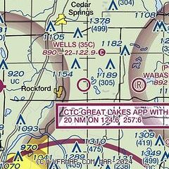
| Sectional chart |
|---|
|
| Airport distance calculator |
|---|
|
|
| Sunrise and sunset |
|---|
|
Times for 24-Apr-2024
| | Local
(UTC-4) | | Zulu
(UTC) |
|---|
| Morning civil twilight | | 06:15 | | 10:15 |
| Sunrise | | 06:45 | | 10:45 |
| Sunset | | 20:35 | | 00:35 |
| Evening civil twilight | | 21:05 | | 01:05 |
|
| Current date and time |
|---|
| Zulu (UTC) | 25-Apr-2024 00:30:15 |
|---|
| Local (UTC-4) | 24-Apr-2024 20:30:15 |
|---|
|
| METAR |
|---|
KGRR
15nm S | 242353Z 25011KT 10SM BKN045 09/01 A3024 RMK AO2 SLP244 T00890006 10111 20072 53003
|
KY70
23nm SE | 250010Z AUTO 11006KT 10SM CLR 07/M01 A3024 RMK AO2
|
KFFX
28nm NW | 250015Z AUTO 34008KT 10SM CLR 08/M04 A3024 RMK AO2 T00761036
|
|
| TAF |
|---|
KGRR
15nm S | 241720Z 2418/2518 03007KT P6SM SCT035 FM242100 04006KT P6SM SKC FM250800 09003KT P6SM FEW250 FM251500 04005KT P6SM SKC
|
|
| NOTAMs |
|---|
NOTAMs are issued by the DoD/FAA and will open in a separate window not controlled by AirNav.
|
|

