FAA INFORMATION EFFECTIVE 18 APRIL 2024
Location
| FAA Identifier: | 3B5 |
| Lat/Long: | 44-11-20.2000N 070-13-58.3000W
44-11.336667N 070-13.971667W
44.1889444,-70.2328611
(estimated) |
| Elevation: | 355.3 ft. / 108.3 m (surveyed) |
| Variation: | 17W (1985) |
| From city: | 4 miles S of TURNER, ME |
| Time zone: | UTC -4 (UTC -5 during Standard Time) |
| Zip code: | 04282 |
Airport Operations
| Airport use: | Open to the public |
| Activation date: | 12/1946 |
| Control tower: | no |
| ARTCC: | BOSTON CENTER |
| FSS: | BANGOR FLIGHT SERVICE STATION |
| NOTAMs facility: | BGR (NOTAM-D service available) |
| Attendance: | MON-SAT 0800-1700
CLSD SUN. |
| Wind indicator: | yes |
| Segmented circle: | no |
Airport Communications
| CTAF/UNICOM: | 122.8 |
| PORTLAND APPROACH: | 125.5 [0545-0000] |
| PORTLAND DEPARTURE: | 125.5 [0545-0000] |
| WX AWOS-3PT at LEW (9 nm S): | 118.025 (207-783-2806) |
Nearby radio navigation aids
| VOR radial/distance | | VOR name | | Freq | | Var |
|---|
| AUGr265/20.3 | | AUGUSTA VOR/DME | | 114.95 | | 18W |
Airport Services
| Fuel available: | MOGAS |
| Airframe service: | MAJOR |
| Powerplant service: | MAJOR |
| Bottled oxygen: | NONE |
| Bulk oxygen: | NONE |
Runway Information
Runway 12/30
| Dimensions: | 2104 x 50 ft. / 641 x 15 m |
| Surface: | asphalt, in good condition |
| Weight bearing capacity: | |
| Runway edge markings: | NRS & CNTRLN FADED.
NRS & CNTRLN NON-STD LEN & WID. |
| RUNWAY 12 | | RUNWAY 30 |
| Latitude: | 44-11.418898N | | 44-11.300287N |
| Longitude: | 070-14.172663W | | 070-13.720545W |
| Elevation: | 355.3 ft. | | 349.5 ft. |
| Traffic pattern: | left | | left |
| Runway heading: | 127 magnetic, 110 true | | 307 magnetic, 290 true |
| Markings: | NSTD, in poor condition | | NSTD, in poor condition |
| Touchdown point: | yes, no lights | | yes, no lights |
| Obstructions: | 60 ft. trees, 201 ft. from runway, 50 ft. left of centerline
+55 FT TREES 0-200 FT 42 FT L; +6-15 FT TREES 0-50 FT FM THR. | | 45 ft. trees, 230 ft. from runway, 60 ft. left and right of centerline
+15 FT BRUSH 190 FT FM THR ON CNTRLN; +40 FT TREES 0-200 FT FM THR 100 FT R; +4 FT FENCE 175 FT FM THR 90 FT R; 10 FT ROADWAY 20 FT FM THR. |
Runway 11/29
| Dimensions: | 2151 x 100 ft. / 656 x 30 m |
| Surface: | turf, in good condition |
| RUNWAY 11 | | RUNWAY 29 |
| Latitude: | 44-11.348008N | | 44-11.281432N |
| Longitude: | 070-14.237778W | | 070-13.754542W |
| Elevation: | 354.1 ft. | | 349.0 ft. |
| Traffic pattern: | left | | left |
| Runway heading: | 118 magnetic, 101 true | | 298 magnetic, 281 true |
| Markings: | none | | none |
| Obstructions: | 15 ft. road, 100 ft. right of centerline
+38 FT PWR LN 140-180 FT FM THR MARKED WITH BALLS ACRS APCH. | | 50 ft. trees, 480 ft. from runway, 9:1 slope to clear
+20 FT POLE 145 FT FM END OF RWY, 30 FT R OF CNTRLN; +25 FT BLDG 145 FT FM END OF RWY, 90 FT R OF CNTRLN. |
Runway 4W/22W
| Dimensions: | 10000 x 1000 ft. / 3048 x 305 m |
| Surface: | water |
| RUNWAY 4W | | RUNWAY 22W |
| Traffic pattern: | left | | left |
Runway 15W/33W
| Dimensions: | 5000 x 1000 ft. / 1524 x 305 m |
| Surface: | water |
| RUNWAY 15W | | RUNWAY 33W |
| Traffic pattern: | left | | left |
Airport Ownership and Management from official FAA records
| Ownership: | Privately-owned |
| Owner: | CROSSWINDS AIR
200 AUBURN RD
TURNER, ME 04282
Phone 207-225-2694 |
| Manager: | MARK MCGHEE
40 AIRPORT RD
TURNER, ME 04282
Phone 207-225-3490 |
Airport Operational Statistics
| Aircraft based on the field: | | 60 | | Single engine airplanes: | | 60 |
| |  | |
| Aircraft operations: avg 47/day * | | 65% | local general aviation | | 35% | transient general aviation | | * for 12-month period ending 16 August 2021 | |
Additional Remarks
| - | TURKEY, GEESE & DEER ON & INVOF ARPT. |
| - | FOR CD CTC PORTLAND APCH AT 207-874-7320, WHEN APCH CLSD CTC BOSTON ARTCC AT 603-879-6859. |
Instrument Procedures
There are no published instrument procedures at 3B5.
Some nearby airports with instrument procedures:
KLEW - Auburn/Lewiston Municipal Airport (9 nm S)
81B - Oxford County Regional Airport (11 nm W)
KAUG - Augusta State Airport (20 nm NE)
KBXM - Brunswick Executive Airport (22 nm SE)
KIWI - Wiscasset Airport (26 nm SE)
|
|

Road maps at:
MapQuest
Bing
Google
| Aerial photo |
|---|
WARNING: Photo may not be current or correct
 Photo by Pete Chaisson Portland Flight Services
Photo taken 19-Sep-2014
looking west.
Photo by Pete Chaisson Portland Flight Services
Photo taken 19-Sep-2014
looking west.
Do you have a better or more recent aerial photo of Twitchell Airport that you would like to share? If so, please send us your photo.
|
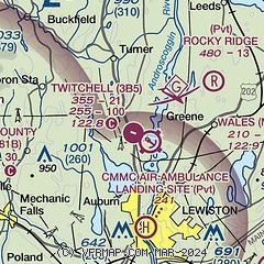
| Sectional chart |
|---|
|
| Airport distance calculator |
|---|
|
|
| Sunrise and sunset |
|---|
|
Times for 19-Apr-2024
| | Local
(UTC-4) | | Zulu
(UTC) |
|---|
| Morning civil twilight | | 05:19 | | 09:19 |
| Sunrise | | 05:50 | | 09:50 |
| Sunset | | 19:30 | | 23:30 |
| Evening civil twilight | | 20:00 | | 00:00 |
|
| Current date and time |
|---|
| Zulu (UTC) | 19-Apr-2024 15:47:19 |
|---|
| Local (UTC-4) | 19-Apr-2024 11:47:19 |
|---|
|
| METAR |
|---|
KLEW
9nm S | 191456Z AUTO 16008KT 10SM OVC060 11/01 A3018 RMK AO2 SLP228 T01060006 58010
|
|
| TAF |
|---|
KAUG
20nm NE | 191136Z 1912/2012 00000KT P6SM BKN080 FM191400 16009G17KT P6SM BKN070 FM200200 18008KT P6SM BKN040 FM200500 18010G18KT P6SM VCSH OVC022 FM201000 19008KT P6SM -RA OVC008
|
|
| NOTAMs |
|---|
NOTAMs are issued by the DoD/FAA and will open in a separate window not controlled by AirNav.
|
|

