FAA INFORMATION EFFECTIVE 18 APRIL 2024
Location
| FAA Identifier: | 3TR |
| Lat/Long: | 41-50-09.2000N 086-13-30.6000W
41-50.153333N 086-13.510000W
41.8358889,-86.2251667
(estimated) |
| Elevation: | 750.4 ft. / 228.7 m (surveyed) |
| Variation: | 05W (2010) |
| From city: | 2 miles NE of NILES, MI |
| Time zone: | UTC -4 (UTC -5 during Standard Time) |
| Zip code: | 49120 |
Airport Operations
| Airport use: | Open to the public |
| Activation date: | 04/1940 |
| Control tower: | no |
| ARTCC: | CHICAGO CENTER |
| FSS: | LANSING FLIGHT SERVICE STATION |
| NOTAMs facility: | LAN (NOTAM-D service available) |
| Attendance: | UNATNDD |
| Wind indicator: | lighted |
| Segmented circle: | yes |
| Lights: | ACTVT REIL RWY 15 & 33; PAPI RWY 15 & 33; MIRL RWY 15/33 - CTAF. |
| Beacon: | white-green (lighted land airport)
Operates sunset to sunrise. |
Airport Communications
| CTAF/UNICOM: | 122.8 |
| SOUTH BEND APPROACH: | 118.55 |
| SOUTH BEND DEPARTURE: | 118.55 |
| WX ASOS at SBN (9 nm SW): | 120.675 (574-251-2652) |
| WX AWOS-3 at EKM (12 nm SE): | 124.475 (574-264-9002) |
| WX ASOS at BEH (20 nm NW): | 121.55 (269-925-9008) |
- APCH/DEP SVC PRVDD BY CHICAGO ARTCC ON 127.55/307.175 (GOSHEN RCAG) WHEN SOUTH BEND APCH CTL CLSD.
Nearby radio navigation aids
| VOR radial/distance | | VOR name | | Freq | | Var |
|---|
| GIJr046/5.8 | | GIPPER VORTAC | | 115.40 | | 00E |
| ELXr194/19.1 | | KEELER VOR/DME | | 116.60 | | 00E |
| GSHr335/20.6 | | GOSHEN VORTAC | | 113.70 | | 00E |
| PMMr188/38.2 | | PULLMAN VOR/DME | | 112.10 | | 00E |
| NDB name | | Hdg/Dist | | Freq | | Var | | ID |
|---|
| MISHA | | 003/7.8 | | 341 | | 05W | | SB | ... -... |
| STURGIS | | 276/35.4 | | 382 | | 04W | | IRS | .. .-. ... |
Airport Services
| Fuel available: | 100LL
100LL:SELF SVC FUEL. |
| Parking: | tiedowns |
| Bottled oxygen: | NONE |
| Bulk oxygen: | NONE |
Runway Information
Runway 15/33
| Dimensions: | 4100 x 75 ft. / 1250 x 23 m |
| Surface: | asphalt, in poor condition
NMRS CRACKS IN PAVEMENT. |
| Weight bearing capacity: | |
| Runway edge lights: | medium intensity |
| RUNWAY 15 | | RUNWAY 33 |
| Latitude: | 41-50.409792N | | 41-49.850575N |
| Longitude: | 086-13.747948W | | 086-13.242285W |
| Elevation: | 741.4 ft. | | 750.4 ft. |
| Traffic pattern: | left | | left |
| Runway heading: | 151 magnetic, 146 true | | 331 magnetic, 326 true |
| Displaced threshold: | 300 ft. | | no |
| Markings: | basic, in good condition | | basic, in good condition |
| Visual slope indicator: | 4-light PAPI on left (4.00 degrees glide path)
PAPI UNUSBL BYD 5 DEGS LEFT OR RIGHT OF CNTRLN. | | 4-light PAPI on left (4.00 degrees glide path)
PAPI UNUSBL BYD 3 DEGS LEFT OR RIGHT OF CNTRLN. |
| Runway end identifier lights: | yes | | yes |
| Touchdown point: | yes, no lights | | yes, no lights |
| Obstructions: | 63 ft. tree, lighted, 502 ft. from runway, 250 ft. left of centerline, 4:1 slope to clear
APCH RATIO 12:1 TO DTHR OVR 63 FT TREE, 791 FT DIST, 270 FT R. | | 45 ft. trees, 200 ft. from runway, 240 ft. right of centerline
CTLG OBSTN EXCEEDS A 45 DEG SLP. |
Runway 4/22
| Dimensions: | 3316 x 55 ft. / 1011 x 17 m |
| Surface: | asphalt, in poor condition
CRACKED & BROKEN PAVEMENT. |
| Weight bearing capacity: | |
| RUNWAY 4 | | RUNWAY 22 |
| Latitude: | 41-49.955927N | | 41-50.409210N |
| Longitude: | 086-13.733142W | | 086-13.326252W |
| Elevation: | 736.9 ft. | | 741.9 ft. |
| Traffic pattern: | left | | left |
| Runway heading: | 039 magnetic, 034 true | | 219 magnetic, 214 true |
| Displaced threshold: | 898 ft. | | 750 ft. |
| Markings: | none | | none |
| Runway end identifier lights: | no | | no |
| Touchdown point: | yes, no lights | | yes, no lights |
| Obstructions: | 13 ft. tree, 200 ft. from runway, 110 ft. left of centerline
13 FT TREE, 199 FT DIST, 110 FT L. | | 66 ft. trees, 454 ft. from runway, 70 ft. right of centerline, 3:1 slope to clear
APCH RATIO 16:1 TO DTHR OVR 80 FT TREES, 1320 FT DIST, 255 FT R. |
Airport Ownership and Management from official FAA records
| Ownership: | Publicly-owned |
| Owner: | CITY OF NILES
333 N 2ND ST STE 301
NILES, MI 49120-2258
Phone 269-683-4700 |
| Manager: | JOSEPH RAY
333 N 2ND ST STE 301
NILES, MI 49120-2258
Phone 269-240-8025 |
Airport Operational Statistics
| Aircraft based on the field: | | 28 | | Single engine airplanes: | | 25 | | Multi engine airplanes: | | 2 | | Helicopters: | | 1 |
| |  | |
| Aircraft operations: avg 58/week * | | 50% | transient general aviation | | 50% | local general aviation | | <1% | military | | * for 12-month period ending 31 December 2015 | |
Additional Remarks
| - | RWY 15 TRSN ZONE +51 FT OBSTN LGTD POLES. |
| - | TREES BTN RYS 04 & 33 BTN RYS 33 & 22 OBSTRUCT VIEW OF RY ENDS. |
| - | GCO AVBL ON FREQ 121.725 THRU SBN CD & FLT SVCS. |
| - | FOR CD IF UNA VIA GCO CTC SOUTH BEND APCH AT 574-251-2609. WHEN SOUTH BEND APCH CLSD, FOR CD CTC CHICAGO ARTCC AT 630-906-8921. |
Instrument Procedures
NOTE: All procedures below are presented as PDF files. If you need a reader for these files, you should download the free Adobe Reader.NOT FOR NAVIGATION. Please procure official charts for flight.
FAA instrument procedures published for use from 18 April 2024 at 0901Z to 16 May 2024 at 0900Z.
IAPs - Instrument Approach Procedures |
|---|
| RNAV (GPS) RWY 15 | |
download (201KB) |
| RNAV (GPS) RWY 33 | |
download (213KB) |
| VOR-A | |
download (174KB) |
| NOTE: Special Take-Off Minimums/Departure Procedures apply | |
download (327KB) |
Other nearby airports with instrument procedures:
KSBN - South Bend International Airport (9 nm SW)
C20 - Andrews University Airpark (9 nm NW)
C91 - Dowagiac Municipal Airport (10 nm NE)
KEKM - Elkhart Municipal Airport (12 nm SE)
KBEH - Southwest Michigan Regional Airport (20 nm NW)
|
|

Road maps at:
MapQuest
Bing
Google
| Aerial photo |
|---|
WARNING: Photo may not be current or correct
 Photo © 2005 Karla Scott, New Carlisle, IN
Taken in 2005
Photo © 2005 Karla Scott, New Carlisle, IN
Taken in 2005
Do you have a better or more recent aerial photo of Jerry Tyler Memorial Airport that you would like to share? If so, please send us your photo.
|
| Sectional chart |
|---|
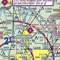
|
| Airport distance calculator |
|---|
|
|
| Sunrise and sunset |
|---|
|
Times for 25-Apr-2024
| | Local
(UTC-4) | | Zulu
(UTC) |
|---|
| Morning civil twilight | | 06:19 | | 10:19 |
| Sunrise | | 06:49 | | 10:49 |
| Sunset | | 20:36 | | 00:36 |
| Evening civil twilight | | 21:06 | | 01:06 |
|
| Current date and time |
|---|
| Zulu (UTC) | 25-Apr-2024 10:11:38 |
|---|
| Local (UTC-4) | 25-Apr-2024 06:11:38 |
|---|
|
| METAR |
|---|
KSBN
9nm SW | 250954Z 00000KT 7SM CLR M01/M03 A3033 RMK AO2 SLP279 T10111028
|
KEKM
12nm SE | 250955Z 00000KT 9SM CLR M01/M01 A3033 RMK AO2 T10141014 $
|
KBEH
20nm NW | 250953Z AUTO 00000KT 9SM CLR M01/M03 A3033 RMK AO2 SLP279 I1000 T10111028
|
|
| TAF |
|---|
KSBN
9nm SW | 250520Z 2506/2606 04003KT P6SM FEW250 FM251400 12006KT P6SM BKN250
|
|
| NOTAMs |
|---|
NOTAMs are issued by the DoD/FAA and will open in a separate window not controlled by AirNav.
|
|

