FAA INFORMATION EFFECTIVE 18 APRIL 2024
Location
| FAA Identifier: | 5G7 |
| Lat/Long: | 40-53-07.6000N 083-52-07.1000W
40-53.126667N 083-52.118333W
40.8854444,-83.8686389
(estimated) |
| Elevation: | 850.6 ft. / 259.3 m (surveyed) |
| Variation: | 05W (1985) |
| From city: | 1 mile SE of BLUFFTON, OH |
| Time zone: | UTC -4 (UTC -5 during Standard Time) |
| Zip code: | 45817 |
Airport Operations
| Airport use: | Open to the public |
| Activation date: | 01/1947 |
| Control tower: | no |
| ARTCC: | CLEVELAND CENTER |
| FSS: | CLEVELAND FLIGHT SERVICE STATION |
| NOTAMs facility: | CLE (NOTAM-D service available) |
| Attendance: | 0900-1700 |
| Wind indicator: | lighted |
| Segmented circle: | no |
| Lights: | ACTVT REIL RWY 05 & 23; PAPI RWY 23; MIRL RWY 05/23 - CTAF. |
| Beacon: | white-green (lighted land airport)
Operates sunset to sunrise. |
Airport Communications
| CTAF/UNICOM: | 122.8 |
| TOLEDO APPROACH: | 120.8 |
| TOLEDO DEPARTURE: | 120.8 |
| WX AWOS-3 at OWX (10 nm NW): | 120.525 (419-523-4151) |
| WX ASOS at FDY (12 nm NE): | 132.85 (419-427-8524) |
| WX ASOS at AOH (13 nm SW): | 128.725 (419-224-6098) |
| WX AWOS-3 at I95 (19 nm SE): | 126.4 (419-675-0781) |
Nearby radio navigation aids
| VOR radial/distance | | VOR name | | Freq | | Var |
|---|
| FBCr233/6.6 | | FLAG CITY VORTAC | | 108.20 | | 02W |
| RODr017/36.7 | | ROSEWOOD VORTAC | | 117.50 | | 05W |
| BUDr299/(40.0) | | BUCKEYE VOR | | 109.80 | | 05W |
| NDB name | | Hdg/Dist | | Freq | | Var | | ID |
|---|
| TIFFIN | | 252/32.2 | | 269 | | 05W | | TII | - .. .. |
Airport Services
| Fuel available: | 100LL JET-A |
| Parking: | hangars and tiedowns |
| Airframe service: | MAJOR |
| Powerplant service: | MAJOR |
| Bottled oxygen: | NONE |
| Bulk oxygen: | NONE |
Runway Information
Runway 5/23
| Dimensions: | 4126 x 75 ft. / 1258 x 23 m |
| Surface: | asphalt, in good condition |
| Weight bearing capacity: | |
| Runway edge lights: | medium intensity |
| RUNWAY 5 | | RUNWAY 23 |
| Latitude: | 40-52.916067N | | 40-53.336805N |
| Longitude: | 083-52.469802W | | 083-51.766968W |
| Elevation: | 850.6 ft. | | 846.7 ft. |
| Traffic pattern: | left | | left |
| Runway heading: | 057 magnetic, 052 true | | 237 magnetic, 232 true |
| Markings: | nonprecision, in good condition | | nonprecision, in good condition |
| Visual slope indicator: | | | 4-light PAPI on left (3.00 degrees glide path)
PAPI UNUSBL BYD 9 DEGS RIGHT OF CNTRLN. |
| Runway end identifier lights: | yes | | yes |
| Touchdown point: | yes, no lights | | yes, no lights |
| Obstructions: | 52 ft. trees, 634 ft. from runway, 130 ft. left of centerline, 8:1 slope to clear | | 8 ft. crops, 201 ft. from runway, 160 ft. left of centerline, 1:1 slope to clear
+8 FT CROPS, 125 FT DIST, 250 FT L EXTDG TO 200 FT DIST, 158 FT L. |
Airport Ownership and Management from official FAA records
| Ownership: | Publicly-owned |
| Owner: | VILLAGE OF BLUFFTON
PO BOX 63
BLUFFTON, OH 45817-0063
Phone 419-358-2066 |
| Manager: | NICK VANCE
1080 NAVAJO DR
BLUFFTON, OH 45817-9691
Phone 419-358-7045 |
Airport Operational Statistics
| Aircraft based on the field: | | 19 | | Single engine airplanes: | | 18 | | Helicopters: | | 1 |
| |  | |
| Aircraft operations: avg 117/day * | | 55% | transient general aviation | | 38% | local general aviation | | 7% | air taxi | | <1% | military | | * for 12-month period ending 11 August 2022 | |
Additional Remarks
| - | FOR CD CTC TOLEDO APCH AT 419-865-1495. |
| - | DEER & BIRDS ON & INVOF ARPT. |
Instrument Procedures
NOTE: All procedures below are presented as PDF files. If you need a reader for these files, you should download the free Adobe Reader.NOT FOR NAVIGATION. Please procure official charts for flight.
FAA instrument procedures published for use from 18 April 2024 at 0901Z to 16 May 2024 at 0900Z.
IAPs - Instrument Approach Procedures |
|---|
| RNAV (GPS) RWY 23 | |
download (178KB) |
| VOR RWY 23 | |
download (187KB) |
| NOTE: Special Take-Off Minimums/Departure Procedures apply | |
download (237KB) |
Other nearby airports with instrument procedures:
KOWX - Putnam County Airport (10 nm NW)
KFDY - Findlay Airport (12 nm NE)
KAOH - Lima Allen County Airport (13 nm SW)
I95 - Hardin County Airport (19 nm SE)
56D - Wyandot County Airport (25 nm E)
|
|

Road maps at:
MapQuest
Bing
Google
| Aerial photo |
|---|
WARNING: Photo may not be current or correct

Do you have a better or more recent aerial photo of Bluffton Airport that you would like to share? If so, please send us your photo.
|
| Sectional chart |
|---|
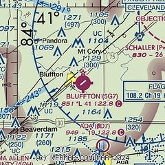
|
| Airport distance calculator |
|---|
|
|
| Sunrise and sunset |
|---|
|
Times for 19-Apr-2024
| | Local
(UTC-4) | | Zulu
(UTC) |
|---|
| Morning civil twilight | | 06:21 | | 10:21 |
| Sunrise | | 06:50 | | 10:50 |
| Sunset | | 20:19 | | 00:19 |
| Evening civil twilight | | 20:48 | | 00:48 |
|
| Current date and time |
|---|
| Zulu (UTC) | 19-Apr-2024 15:51:07 |
|---|
| Local (UTC-4) | 19-Apr-2024 11:51:07 |
|---|
|
| METAR |
|---|
KOWX
10nm NW | 191515Z AUTO 29015KT 10SM BKN020 BKN027 12/06 A3006 RMK AO1
|
KFDY
12nm NE | 191539Z AUTO 29013KT 10SM BKN016 OVC022 11/07 A3002 RMK AO2 T01110067
|
KAOH
13nm SW | 191538Z AUTO 29012G22KT 10SM SCT011 BKN017 OVC022 11/08 A3004 RMK AO2 T01110083
|
|
| TAF |
|---|
KFDY
12nm NE | 191131Z 1912/2012 31014G24KT P6SM OVC010 TEMPO 1912/1914 4SM BR BKN004 FM191600 31015G23KT P6SM BKN025 FM191800 29015G25KT P6SM SKC FM200100 29007KT P6SM BKN250
|
|
| NOTAMs |
|---|
NOTAMs are issued by the DoD/FAA and will open in a separate window not controlled by AirNav.
|
|
