FAA INFORMATION EFFECTIVE 18 APRIL 2024
Location
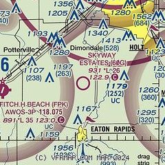
| FAA Identifier: | 60G |
| Lat/Long: | 42-35-01.7100N 084-39-05.3300W
42-35.028500N 084-39.088833W
42.5838083,-84.6514806
(estimated) |
| Elevation: | 931 ft. / 284 m (estimated) |
| Variation: | 05W (1995) |
| From city: | 4 miles N of EATON RAPIDS, MI |
| Time zone: | UTC -4 (UTC -5 during Standard Time) |
| Zip code: | 48827 |
Airport Operations
| Airport use: | Open to the public |
| Activation date: | 12/1970 |
| Control tower: | no |
| ARTCC: | CLEVELAND CENTER |
| FSS: | LANSING FLIGHT SERVICE STATION |
| NOTAMs facility: | LAN (NOTAM-D service available) |
| Attendance: | IREG |
| Wind indicator: | lighted |
| Segmented circle: | yes |
| Lights: | ACTVT MIRL RWY 08/26 - CTAF. |
| Beacon: | white-green (lighted land airport)
ACTVT ABN SS-SR - CTAF. |
Airport Communications
| CTAF: | 122.9 |
| GREAT LAKES APPROACH: | 118.65 |
| GREAT LAKES DEPARTURE: | 118.65 |
| WX AWOS-3P at FPK (7 nm W): | 118.075 (517-543-2288) |
| WX AWOS-3P at TEW (10 nm E): | 119.425 (517-676-5607) |
| WX ASOS at LAN (12 nm N): | PHONE 517-908-8494 |
- APCH/DEP SVC PRVDD BY CLEVELAND ARTCC (ZOB) ON FREQS 120.45/360.7 (LITCHFIELD RCAG) WHEN GREAT LAKES APCH CTL CLSD.
Nearby radio navigation aids
| VOR radial/distance | | VOR name | | Freq | | Var |
|---|
| VIOr112/39.2 | | VICTORY VOR/DME | | 115.95 | | 04W |
Airport Services
Runway Information
Runway 8/26
| Dimensions: | 2653 x 100 ft. / 809 x 30 m |
| Surface: | turf, in good condition
SOFT WHEN WET, VFY FLD CONDS WITH AMGR. |
| Runway edge lights: | medium intensity |
| Runway edge markings: | RWY & DTHR MKD WITH 3 FT YELLOW CONES. |
| RUNWAY 8 | | RUNWAY 26 |
| Latitude: | 42-35.002167N | | 42-35.054833N |
| Longitude: | 084-39.382167W | | 084-38.795500W |
| Elevation: | 931.0 ft. | | 931.0 ft. |
| Traffic pattern: | left | | left |
| Runway heading: | 088 magnetic, 083 true | | 268 magnetic, 263 true |
| Displaced threshold: | 685 ft. | | 400 ft. |
| Touchdown point: | yes, no lights | | yes, no lights |
| Obstructions: | 45 ft. trees, 112 ft. left of centerline
CTLG OBSTN EXCEEDS A 45 DEG SLP. APCH RATIO 20:1 TO DTHR BASED ON STRAIGHT OUT OVR 69 FT TREES, 1400 FT DIST, 0 FT B. | | 30 ft. trees, 25 ft. from runway
CTLG OBSTN EXCEEDS A 45 DEG SLP. APCH RATIO 21:1 TO DTHR BASED ON STRAIGHT OUT OVR 35 FT TREES, 750 FT DIST, 0 FT B. |
Airport Ownership and Management from official FAA records
| Ownership: | Privately-owned |
| Owner: | SKYWAY ESTATES ASSN, INC
9449 COLUMBIA HWY
EATON RAPIDS, MI 48827-8357
Phone 517-667-0182 |
| Manager: | KEITH GIBBS
9445 COLUMBIA HWY
EATON RAPIDS, MI 48827-8357
Phone 517-667-0182 |
Airport Operational Statistics
| Aircraft based on the field: | | 5 | | Single engine airplanes: | | 5 |
| |  | |
| Aircraft operations: avg 33/month * | | 50% | transient general aviation | | 50% | local general aviation | | * for 12-month period ending 31 December 2022 | |
Additional Remarks
| - | UAS OPS S OF RWY 08/26. |
| - | FOR CD CTC GREAT LAKES APCH AT 269-459-3345, WHEN APCH CLSD CTC CLEVELAND ARTCC AT 440-774-0224/0490. |
Instrument Procedures
There are no published instrument procedures at 60G.
Some nearby airports with instrument procedures:
KFPK - Fitch H Beach Airport (7 nm W)
KTEW - Mason Jewett Field Airport (10 nm E)
4D0 - Abrams Municipal Airport (12 nm N)
KLAN - Capital Region International Airport (12 nm N)
KJXN - Jackson County Airport/Reynolds Field (21 nm SE)
|
|

Road maps at:
MapQuest
Bing
Google
| Aerial photo |
|---|
WARNING: Photo may not be current or correct

Do you have a better or more recent aerial photo of Skyway Estates Airport that you would like to share? If so, please send us your photo.
|
| Sectional chart |
|---|
|
| Airport distance calculator |
|---|
|
|
| Sunrise and sunset |
|---|
|
Times for 24-Apr-2024
| | Local
(UTC-4) | | Zulu
(UTC) |
|---|
| Morning civil twilight | | 06:13 | | 10:13 |
| Sunrise | | 06:43 | | 10:43 |
| Sunset | | 20:30 | | 00:30 |
| Evening civil twilight | | 21:01 | | 01:01 |
|
| Current date and time |
|---|
| Zulu (UTC) | 24-Apr-2024 05:45:37 |
|---|
| Local (UTC-4) | 24-Apr-2024 01:45:37 |
|---|
|
| METAR |
|---|
KFPK
7nm W | 240535Z AUTO 29009KT 10SM BKN022 BKN080 09/07 A2986 RMK AO2
|
KTEW
10nm E | 240535Z AUTO 27005KT 10SM SCT060 SCT070 10/07 A2986 RMK AO2 T00950073
|
KLAN
12nm N | 240453Z 24004KT 10SM BKN065 09/08 A2984 RMK AO2 SLP107 T00940078 401560089
|
|
| TAF |
|---|
KLAN
12nm N | 240355Z 2404/2424 22010G15KT P6SM VCSH BKN060 FM240500 30009KT P6SM BKN025 FM240700 32010G20KT P6SM BKN018 FM241500 02011KT P6SM SCT025
|
|
| NOTAMs |
|---|
NOTAMs are issued by the DoD/FAA and will open in a separate window not controlled by AirNav.
|
|
