FAA INFORMATION EFFECTIVE 18 APRIL 2024
Location
| FAA Identifier: | 6G8 |
| Lat/Long: | 42-05-39.1750N 084-14-27.4250W
42-05.652917N 084-14.457083W
42.0942153,-84.2409514
(estimated) |
| Elevation: | 987 ft. / 301 m (estimated) |
| Variation: | 05W (1985) |
| From city: | 1 mile SE of BROOKLYN, MI |
| Time zone: | UTC -4 (UTC -5 during Standard Time) |
| Zip code: | 49230 |
Airport Operations
| Airport use: | Open to the public |
| Activation date: | 12/1975 |
| Control tower: | no |
| ARTCC: | CLEVELAND CENTER |
| FSS: | LANSING FLIGHT SERVICE STATION |
| NOTAMs facility: | LAN (NOTAM-D service available) |
| Attendance: | IREG |
| Wind indicator: | lighted |
| Segmented circle: | yes |
| Lights: | LIRL RWY 01/19 OTS INDEFLY. |
| Landing fee: | no, OVERNIGHT FEE. |
Airport Communications
| CTAF: | 122.9 |
| WX ASOS at JXN (14 nm NW): | PHONE 517-768-7506 |
| WX ASOS at ADG (15 nm SE): | 118.375 (517-265-9089) |
| WX AWOS-3 at JYM (19 nm SW): | 121.025 (517-437-5638) |
Nearby radio navigation aids
| VOR radial/distance | | VOR name | | Freq | | Var |
|---|
| SVMr240/34.4 | | SALEM VORTAC | | 114.30 | | 03W |
| CRLr278/35.0 | | CARLETON VOR/DME | | 115.70 | | 03W |
| DXOr266/39.5 | | DETROIT VOR/DME | | 113.40 | | 06W |
| NDB name | | Hdg/Dist | | Freq | | Var | | ID |
|---|
| ADRIAN | | 338/15.3 | | 278 | | 06W | | ADG | .- -.. --. |
| TECUMSEH | | 289/16.2 | | 239 | | 06W | | TCU | - -.-. ..- |
Airport Services
| Parking: | hangars and tiedowns |
Runway Information
Runway 1/19
| Dimensions: | 2822 x 100 ft. / 860 x 30 m |
| Surface: | turf, in good condition |
| Runway edge lights: | low intensity |
| Runway edge markings: | 3 FT YELLOW CONES; DTHR MKD WITH 3 CONES EACH SIDE. |
| RUNWAY 1 | | RUNWAY 19 |
| Latitude: | 42-05.423167N | | 42-05.882667N |
| Longitude: | 084-14.503167W | | 084-14.411000W |
| Elevation: | 980.0 ft. | | 981.0 ft. |
| Traffic pattern: | right | | left |
| Runway heading: | 013 magnetic, 008 true | | 193 magnetic, 188 true |
| Displaced threshold: | no | | 613 ft. |
| Obstructions: | 32 ft. tree, 44 ft. from runway, 107 ft. left of centerline, 1:1 slope to clear
APCH RATIO 20:1 TO DTHR OVR 105 FT TWR, 2118 FT DIST, 110 FT L. | | 52 ft. trees, marked, 435 ft. from runway, 140 ft. right of centerline, 8:1 slope to clear |
Airport Ownership and Management from official FAA records
| Ownership: | Privately-owned |
| Owner: | CRAIG PEARSON
PO BOX 324
BROOKLYN, MI 49230-0324
Phone 586-646-8199
RESIDES ON ARPT PREMISES. |
| Manager: | CRAIG PEARSON
PO BOX 324
BROOKLYN, MI 49230-0324
Phone 586-646-8199 |
Airport Operational Statistics
| Aircraft based on the field: | | 5 | | Single engine airplanes: | | 3 | | Ultralights: | | 2 |
| |  | |
| Aircraft operations: avg 35/week * | | 51% | transient general aviation | | 48% | local general aviation | | 1% | military | | * for 12-month period ending 31 December 2022 | |
Additional Remarks
| - | 105 FT MKD PLINE & TWR, 0.25 NM FM RWY 19 THR, EXTDD L & R OF CNTRLN. |
| - | DEER & BIRDS ON & INVOF ARPT. |
| - | ADMIN BLDG ACES 1-2-2-9. |
| - | FOR CD CTC GREAT LAKES APCH AT 269-459-3345, WHEN APCH CLSD CTC CLEVELAND ARTCC AT 440-774-0229/0490. |
| - | ARPT CLSD WHEN SNOW COVD EXC FOR SKI EQUIPPED ACFT. |
Instrument Procedures
There are no published instrument procedures at 6G8.
Some nearby airports with instrument procedures:
KJXN - Jackson County Airport/Reynolds Field (14 nm NW)
KADG - Lenawee County Airport (15 nm SE)
KJYM - Hillsdale Municipal Airport (19 nm SW)
KARB - Ann Arbor Municipal Airport (23 nm E)
KTEW - Mason Jewett Field Airport (29 nm N)
|
|

Road maps at:
MapQuest
Bing
Google
| Aerial photo |
|---|
WARNING: Photo may not be current or correct
 Credit: M. Coleman - LocalHangar.com
Do you have a better or more recent aerial photo of Brooklyn Airport that you would like to share? If so, please send us your photo.
|
| Sectional chart |
|---|
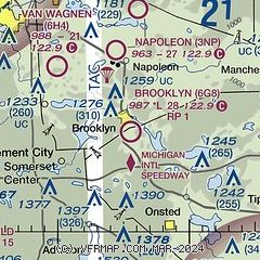
|
| Airport distance calculator |
|---|
|
|
| Sunrise and sunset |
|---|
|
Times for 25-Apr-2024
| | Local
(UTC-4) | | Zulu
(UTC) |
|---|
| Morning civil twilight | | 06:11 | | 10:11 |
| Sunrise | | 06:41 | | 10:41 |
| Sunset | | 20:29 | | 00:29 |
| Evening civil twilight | | 20:59 | | 00:59 |
|
| Current date and time |
|---|
| Zulu (UTC) | 25-Apr-2024 20:05:25 |
|---|
| Local (UTC-4) | 25-Apr-2024 16:05:25 |
|---|
|
| METAR |
|---|
KJXN
14nm NW | 251956Z 10SM CLR 13/M06 A3031 RMK AO2 SLP271 T01281061
|
KADG
15nm SE | 251953Z AUTO VRB03KT 10SM CLR 12/M02 A3034 RMK AO2 SLP280 T01171022
|
KJYM
19nm SW | 251955Z AUTO 04003KT 10SM CLR 11/M20 A3031 RMK AO2 T01131197
|
KARB
24nm E | 734-668-7173
251953Z 10SM CLR 13/M02 A3031 RMK AO2 SLP271 T01281022
|
|
| TAF |
|---|
KJXN
14nm NW | 251720Z 2518/2618 06006KT P6SM SKC FM260100 11004KT P6SM SKC FM261200 10011KT P6SM SKC
|
|
| NOTAMs |
|---|
NOTAMs are issued by the DoD/FAA and will open in a separate window not controlled by AirNav.
|
|

