FAA INFORMATION EFFECTIVE 18 APRIL 2024
Location
| FAA Identifier: | 7D9 |
| Lat/Long: | 41-46-40.1960N 080-54-14.3270W
41-46.669933N 080-54.238783W
41.7778322,-80.9039797
(estimated) |
| Elevation: | 820 ft. / 249.9 m (surveyed) |
| Variation: | 07W (1985) |
| From city: | 3 miles SE of GENEVA, OH |
| Time zone: | UTC -4 (UTC -5 during Standard Time) |
| Zip code: | 44041 |
Airport Operations
| Airport use: | Open to the public |
| Activation date: | 09/1959 |
| Control tower: | no |
| ARTCC: | CLEVELAND CENTER |
| FSS: | CLEVELAND FLIGHT SERVICE STATION |
| NOTAMs facility: | CLE (NOTAM-D service available) |
| Attendance: | 0830-1700 |
| Wind indicator: | yes |
| Segmented circle: | yes |
| Lights: | SS-SR |
Airport Communications
| CTAF: | 122.9 |
| WX ASOS at HZY (9 nm E): | 118.325 (440-576-0219) |
- APCH/DEP SVC PRVDD BY CLEVELAND ARTCC (ZOB) ON 120.775/298.95 (CHARDON RCAG).
Nearby radio navigation aids
| VOR radial/distance | | VOR name | | Freq | | Var |
|---|
| CXRr042/19.5 | | CHARDON VOR/DME | | 112.70 | | 05W |
| YNGr344/28.7 | | YOUNGSTOWN VORTAC | | 109.00 | | 05W |
| NDB name | | Hdg/Dist | | Freq | | Var | | ID |
|---|
| LAKELAND | | 083/22.0 | | 263 | | 08W | | LQL | .-.. --.- .-.. |
Airport Services
| Fuel available: | 100LL
100LL:100LL AVBL AFT ATNDD HRS BY APNTMT. |
| Parking: | tiedowns |
| Airframe service: | MAJOR |
| Powerplant service: | MAJOR |
Runway Information
Runway 1/19
| Dimensions: | 3260 x 28 ft. / 994 x 9 m |
| Surface: | asphalt, in poor condition
HIGHLY DETERIORATED; PAVEMENT ROUGH & UNEVEN ROLLING SFC; NMRS CRACKS, PATCHES, LOOSE AGGREGATE, & FOD. |
| Runway edge lights: | non-standard
SOLAR LED LIGHTS, SPACING NSTD. |
| Runway edge markings: | FADED.
NSTD BASIC DUE TO SPACING & SIZE. |
| RUNWAY 1 | | RUNWAY 19 |
| Latitude: | 41-46.401833N | | 41-46.937667N |
| Longitude: | 080-54.260500W | | 080-54.216667W |
| Elevation: | 820.0 ft. | | 820.0 ft. |
| Traffic pattern: | left | | left |
| Runway heading: | 011 magnetic, 004 true | | 191 magnetic, 184 true |
| Markings: | NSTD, in poor condition | | NSTD, in poor condition |
| Runway end identifier lights: | no | | no |
| Touchdown point: | yes, no lights | | yes, no lights |
| Obstructions: | 46 ft. tree, 224 ft. from runway, 63 ft. left of centerline, 1:1 slope to clear
RWY 01 60 FT TREES 0 FT FR 125 FT EACH SIDE OF RWY CNTRLN EXTDNG 200 FT FR. | | 80 ft. trees, 201 ft. from runway, 15 ft. right of centerline, 1:1 slope to clear
15 FT ROAD, 32 FT DSTC; 35 FT PLINE, 70 FT DSTC, 0 B; GRADE CHGS & 80 FT TREES 79-199 FT DSTC, 0-125 15 FT R. |
Airport Ownership and Management from official FAA records
| Ownership: | Privately-owned |
| Owner: | JOHN WILLIAMS
1419 STATE ROUTE 45
AUSTINBURG, OH 44010-9749
Phone 440-275-3205 |
| Manager: | ALAN KETTUNEN
4180 CLAY ST
GENEVA, OH 44041-9268
Phone 440-645-1982
ALANKETTUNEN@WINDSTREAM.NET. |
Airport Operational Statistics
| Aircraft based on the field: | | 26 | | Single engine airplanes: | | 20 | | Multi engine airplanes: | | 2 | | Jet airplanes: | | 2 | | Ultralights: | | 2 |
| |  | |
| Aircraft operations: avg 23/week * | | 83% | local general aviation | | 17% | transient general aviation | | <1% | military | | * for 12-month period ending 09 September 2022 | |
Additional Remarks
| - | DEER ON & INVOF ARPT. |
| - | ACFT PARKED WI RESA, AER 19, 33 FT RIGHT OF CNTRLN. |
| - | NO LINE OF SIGHT BTN RWY ENDS. |
| - | FOR CD CTC BUFFALO APCH AT 716-626-6920, WHEN APCH CLSD CTC CLEVELAND ARTCC AT 440-774-0232/0490. |
| - | RWY 19: 15 FT ROAD, 32 FT FM RWY END. |
| - | RWY 01: -10 FT DITCH/CREEK AT RWY END. |
Instrument Procedures
There are no published instrument procedures at 7D9.
Some nearby airports with instrument procedures:
KHZY - Northeast Ohio Regional Airport (9 nm E)
2G1 - Concord Airpark (15 nm SW)
7G8 - Geauga County Airport (21 nm S)
KLNN - Lake County Executive Airport (22 nm W)
KCGF - Cuyahoga County Airport (29 nm SW)
|
|

Road maps at:
MapQuest
Bing
Google
| Aerial photo |
|---|
WARNING: Photo may not be current or correct
 Photo by Ron Schreck
Taken in the Spring of 2009
Photo by Ron Schreck
Taken in the Spring of 2009
Do you have a better or more recent aerial photo of Germack Airport that you would like to share? If so, please send us your photo.
|
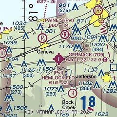
| Sectional chart |
|---|
|
| Airport distance calculator |
|---|
|
|
| Sunrise and sunset |
|---|
|
Times for 24-Apr-2024
| | Local
(UTC-4) | | Zulu
(UTC) |
|---|
| Morning civil twilight | | 06:00 | | 10:00 |
| Sunrise | | 06:29 | | 10:29 |
| Sunset | | 20:14 | | 00:14 |
| Evening civil twilight | | 20:44 | | 00:44 |
|
| Current date and time |
|---|
| Zulu (UTC) | 24-Apr-2024 16:12:16 |
|---|
| Local (UTC-4) | 24-Apr-2024 12:12:16 |
|---|
|
| METAR |
|---|
KHZY
9nm E | 241553Z AUTO 32010KT 10SM OVC008 06/04 A3006 RMK AO2 SLP183 T00610039
|
|
| TAF |
|---|
KYNG
33nm S | 241121Z 2412/2512 26008KT 6SM -RA BR BKN018 TEMPO 2412/2415 32008KT OVC008 FM241500 31009KT P6SM OVC015 FM242300 36010KT P6SM BKN015 FM250400 01004KT P6SM SCT020
|
|
| NOTAMs |
|---|
NOTAMs are issued by the DoD/FAA and will open in a separate window not controlled by AirNav.
|
|

