FAA INFORMATION EFFECTIVE 18 APRIL 2024
Location
| FAA Identifier: | 9D9 |
| Lat/Long: | 42-39-47.9020N 085-20-44.7120W
42-39.798367N 085-20.745200W
42.6633061,-85.3457533
(estimated) |
| Elevation: | 800.4 ft. / 244.0 m (surveyed) |
| Variation: | 06W (2015) |
| From city: | 3 miles W of HASTINGS, MI |
| Time zone: | UTC -4 (UTC -5 during Standard Time) |
| Zip code: | 49058 |
Airport Operations
| Airport use: | Open to the public |
| Activation date: | 07/1945 |
| Control tower: | no |
| ARTCC: | CHICAGO CENTER |
| FSS: | LANSING FLIGHT SERVICE STATION |
| NOTAMs facility: | LAN (NOTAM-D service available) |
| Attendance: | IREG |
| Pattern altitude: | 1600.4 ft. MSL |
| Wind indicator: | lighted |
| Segmented circle: | yes |
| Lights: | ACTVT MIRL RY 12/30, PAPI RY 12 & RY 30, REIL RY 12 & RY 30 - CTAF. |
| Beacon: | white-green (lighted land airport)
Operates sunset to sunrise. |
Airport Communications
| CTAF/UNICOM: | 123.075 |
| GREAT LAKES APPROACH: | 128.4 |
| GREAT LAKES DEPARTURE: | 128.4 |
| WX ASOS at GRR (15 nm NW): | PHONE 616-575-1953 |
- APCH/DEP SVC PRVDD BY CHICAGO ARTCC (ZAU) ON FREQ 128.4 (GRAND RAPIDS RCAG) WHEN GREAT LAKES APCH CTL CLSD.
Nearby radio navigation aids
| VOR radial/distance | | VOR name | | Freq | | Var |
|---|
| VIOr142/10.0 | | VICTORY VOR/DME | | 115.95 | | 04W |
| PMMr071/35.6 | | PULLMAN VOR/DME | | 112.10 | | 00E |
| NDB name | | Hdg/Dist | | Freq | | Var | | ID |
|---|
| KNOBS | | 180/14.0 | | 263 | | 06W | | GR | --. .-. |
Airport Services
| Fuel available: | 100LL JET-A+ |
| Parking: | hangars and tiedowns |
| Airframe service: | MAJOR |
| Powerplant service: | MAJOR |
Runway Information
Runway 12/30
| Dimensions: | 5003 x 75 ft. / 1525 x 23 m |
| Surface: | asphalt, in good condition |
| Weight bearing capacity: | |
| Runway edge lights: | medium intensity |
| RUNWAY 12 | | RUNWAY 30 |
| Latitude: | 42-39.965225N | | 42-39.520468N |
| Longitude: | 085-21.154137W | | 085-20.214975W |
| Elevation: | 797.1 ft. | | 796.7 ft. |
| Traffic pattern: | left | | left |
| Runway heading: | 128 magnetic, 122 true | | 308 magnetic, 302 true |
| Displaced threshold: | 241 ft. | | 251 ft. |
| Markings: | nonprecision, in fair condition | | nonprecision, in fair condition |
| Visual slope indicator: | 4-light PAPI on right (4.00 degrees glide path) | | 4-light PAPI on left (3.00 degrees glide path)
PAPI UNUSBL BYD 5 DEGS LEFT OF CNTRLN. |
| Runway end identifier lights: | yes | | yes |
| Touchdown point: | yes, no lights | | yes, no lights |
| Obstructions: | 39 ft. tree, 592 ft. from runway, 275 ft. right of centerline, 10:1 slope to clear
APCH RATIO 20:1 AT DSPLCD THR. | | 34 ft. tree, 200 ft. from runway, 250 ft. left of centerline, 1:1 slope to clear |
Runway 9/27
| Dimensions: | 2380 x 170 ft. / 725 x 52 m |
| Surface: | turf, in fair condition |
| Runway edge markings: | RWY 09/27 & RWY 18/36 MKD WITH 3 FT YELLOW CONES. |
| RUNWAY 9 | | RUNWAY 27 |
| Latitude: | 42-39.916013N | | 42-39.936933N |
| Longitude: | 085-21.153023W | | 085-20.622918W |
| Elevation: | 794.7 ft. | | 798.2 ft. |
| Traffic pattern: | left | | left |
| Runway heading: | 093 magnetic, 087 true | | 273 magnetic, 267 true |
| Displaced threshold: | 191 ft. | | 374 ft. |
| Touchdown point: | yes, no lights | | yes, no lights |
| Obstructions: | 10 ft. tree, 96 ft. from runway, 11 ft. right of centerline, 9:1 slope to clear
APCH RATIO 15:1 AT DSPLCD THR. +40 FT TREE, 630 FT DIST, 75 FT L. | | 77 ft. tree, 1001 ft. from runway, 248 ft. right of centerline, 13:1 slope to clear
APCH RATIO 19:1 AT DSPLCD THR. +91 FT TREE, 1785 DIST, 0 FT BASE LEG. |
Runway 18/36
| Dimensions: | 1952 x 200 ft. / 595 x 61 m |
| Surface: | turf, in fair condition |
| RUNWAY 18 | | RUNWAY 36 |
| Latitude: | 42-39.945085N | | 42-39.623820N |
| Longitude: | 085-20.728912W | | 085-20.724322W |
| Elevation: | 797.0 ft. | | 798.1 ft. |
| Traffic pattern: | left | | left |
| Runway heading: | 185 magnetic, 179 true | | 005 magnetic, 359 true |
| Touchdown point: | yes, no lights | | yes, no lights |
| Obstructions: | 64 ft. tree, 732 ft. from runway, 171 ft. right of centerline, 11:1 slope to clear | | 38 ft. tree, 233 ft. from runway, 161 ft. right of centerline, 6:1 slope to clear |
Airport Ownership and Management from official FAA records
| Ownership: | Publicly-owned |
| Owner: | HASTINGS CITY-BARRY CO ARPT COMM
2505 MURPHY DR.
HASTINGS, MI 49058
Phone 269-945-6306 |
| Manager: | MARK NOTEBOOM
2505 MURPHY DR.
HASTINGS, MI 49058
Phone 269-945-6306
AMGR CELL 269-838-5874 |
Airport Operational Statistics
| Aircraft based on the field: | | 87 | | Single engine airplanes: | | 73 | | Multi engine airplanes: | | 5 | | Jet airplanes: | | 1 | | Helicopters: | | 7 | | Gliders airplanes: | | 1 |
| |  | |
| Aircraft operations: avg 31/day * | | 43% | transient general aviation | | 43% | local general aviation | | 13% | military | | * for 12-month period ending 31 December 2021 | |
Additional Remarks
| - | LRG FLOCKS OF LRG BIRDS ON & INVOF ARPT. |
| - | FOR CD CTC GREAT LAKES APCH AT 269-459-3344, WHEN APCH CLSD CTC CHICAGO ARTCC AT 630-906-8921. |
Instrument Procedures
NOTE: All procedures below are presented as PDF files. If you need a reader for these files, you should download the free Adobe Reader.NOT FOR NAVIGATION. Please procure official charts for flight.
FAA instrument procedures published for use from 18 April 2024 at 0901Z to 16 May 2024 at 0900Z.
IAPs - Instrument Approach Procedures |
|---|
| RNAV (GPS) RWY 12 | |
download (243KB) |
| RNAV (GPS) RWY 30 | |
download (230KB) |
| VOR RWY 12 | |
download (240KB) |
| NOTE: Special Take-Off Minimums/Departure Procedures apply | |
download (221KB) |
Other nearby airports with instrument procedures:
KGRR - Gerald R Ford International Airport (15 nm NW)
Y70 - Ionia County Airport (21 nm NE)
KBTL - Battle Creek Executive Airport at Kellogg Field (22 nm S)
35D - Padgham Field Airport (23 nm W)
KFPK - Fitch H Beach Airport (24 nm E)
|
|

Road maps at:
MapQuest
Bing
Google
| Aerial photo |
|---|
WARNING: Photo may not be current or correct
 Photo by Kevin Jarchow, 1st Lt CAP
Grand Rapids Senior Squadron (MI-190)
Michigan Wing
U.S. Air Force Auxiliary
Photo taken 11-Nov-2009
Do you have a better or more recent aerial photo of Hastings Airport that you would like to share? If so, please send us your photo.
|
| Sectional chart |
|---|
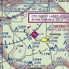
|
| Airport distance calculator |
|---|
|
|
| Sunrise and sunset |
|---|
|
Times for 20-Apr-2024
| | Local
(UTC-4) | | Zulu
(UTC) |
|---|
| Morning civil twilight | | 06:22 | | 10:22 |
| Sunrise | | 06:52 | | 10:52 |
| Sunset | | 20:29 | | 00:29 |
| Evening civil twilight | | 20:59 | | 00:59 |
|
| Current date and time |
|---|
| Zulu (UTC) | 20-Apr-2024 08:40:58 |
|---|
| Local (UTC-4) | 20-Apr-2024 04:40:58 |
|---|
|
| METAR |
|---|
KGRR
15nm NW | 200753Z AUTO 30011KT 10SM FEW045 BKN065 03/M04 A3005 RMK AO2 SLP182 T00331044
|
KY70
21nm NE | 200815Z AUTO 30007KT 10SM BKN048 BKN050 OVC065 03/M06 A3005 RMK AO2 T00331058
|
KBTL
21nm S | 200753Z AUTO 29008KT 10SM FEW046 03/M04 A3006 RMK AO2 SLP185 T00331039
|
KFPK
24nm E | 200815Z AUTO 28009G16KT 10SM BKN050 03/M05 A3004 RMK AO2
|
KAZO
27nm S | 200753Z AUTO 30010KT 10SM CLR 04/M04 A3008 RMK AO2 SLP191 T00391039
|
|
| TAF |
|---|
KGRR
15nm NW | 200525Z 2006/2106 30012G20KT P6SM BKN060 FM201500 28013G21KT P6SM BKN050 FM202200 27008KT P6SM BKN050
|
|
| NOTAMs |
|---|
NOTAMs are issued by the DoD/FAA and will open in a separate window not controlled by AirNav.
|
|

