FAA INFORMATION EFFECTIVE 18 APRIL 2024
Location
| FAA Identifier: | ACY |
| Lat/Long: | 39-27-27.3000N 074-34-37.8000W
39-27.455000N 074-34.630000W
39.4575833,-74.5771667
(estimated) |
| Elevation: | 74.8 ft. / 22.8 m (surveyed) |
| Variation: | 10W (1965) |
| From city: | 9 miles NW of ATLANTIC CITY, NJ |
| Time zone: | UTC -4 (UTC -5 during Standard Time) |
| Zip code: | 08234 |
Airport Operations
| Airport use: | Open to the public |
| Activation date: | 06/1943 |
| Control tower: | yes |
| ARTCC: | WASHINGTON CENTER |
| FSS: | MILLVILLE FLIGHT SERVICE STATION |
| NOTAMs facility: | ACY (NOTAM-D service available) |
| Attendance: | CONTINUOUS |
| Wind indicator: | lighted |
| Segmented circle: | no |
| Beacon: | white-green (lighted land airport)
Operates sunset to sunrise. |
| Landing fee: | yes |
| Fire and rescue: | ARFF index C |
| International operations: | US CUSTOMS USER FEE ARPT.CUSTOMS AVBL MON-FRI
0800-1700. PROVIDE MINIMUM 24 HR ADVANCE NOTICE TO
ARRANGE FOR CUSTOMS. ALL CALLS TO CUSTOMS MON-FRI
0800-1700; PHONE 609-484-1610. US CUSTOMS FAX
609-484-1614.
US CUSTOMS USER FEE ARPT. |
Airport Communications
| ATIS: | 125.725 316.15 |
| WX ASOS: | PHONE 609-272-9311 |
| ATLANTIC CITY GROUND: | 121.9 284.6 |
| ATLANTIC CITY TOWER: | 120.3 239.0 |
| ATLANTIC CITY APPROACH: | 124.6 ;130-309 134.25 ;310-129 292.2 ;N ARR 310-129 327.125 ;130-309 239.0 |
| ATLANTIC CITY DEPARTURE: | 124.6 ;130-309 134.25 ;310-129 327.125 ;130-309 |
| CLEARANCE DELIVERY: | 127.85 353.775 |
| ANG OPS: | 140.7 |
| CLASS C: | 124.6 ;130-309 134.25 ;310-129 292.2 ;N ARR 310-129 327.125 ;130-309 |
| EMERG: | 121.5 243.0 |
| IC: | 124.6 ;130-309 327.125 ;130-309 |
| OPS: | 123.4 ;FAA OPS |
| WX AWOS-AV at 26N (12 nm S): | 119.775 (609-398-0705) |
| WX AWOS-AV at N81 (15 nm NW): | 122.7 |
| WX AWOS-3 at OBI (18 nm SW): | 120.475 (609-861-0610) |
Nearby radio navigation aids
| VOR radial/distance | | VOR name | | Freq | | Var |
|---|
| ACY at field | | ATLANTIC CITY VORTAC | | 117.15 | | 10W |
| VCNr115/18.7 | | CEDAR LAKE VOR/DME | | 115.20 | | 10W |
| CYNr207/22.6 | | COYLE VORTAC | | 113.40 | | 10W |
| SIEr035/24.1 | | SEA ISLE VORTAC | | 114.80 | | 09W |
| GXUr190/33.1 | | MC GUIRE VORTAC | | 110.60 | | 12W |
| OODr118/35.3 | | WOODSTOWN VORTAC | | 112.80 | | 10W |
| NDB name | | Hdg/Dist | | Freq | | Var | | ID |
|---|
| RAINBOW | | 096/26.0 | | 363 | | 11W | | RNB | .-. -. -... |
| LAKEHURST | | 209/37.0 | | 396 | | 11W | | NEL | -. . .-.. |
Airport Services
| Fuel available: | 100LL JET-A JET-A++ |
| Parking: | tiedowns |
| Airframe service: | MAJOR |
| Powerplant service: | MINOR |
| Bottled oxygen: | HIGH |
| Bulk oxygen: | NONE |
Runway Information
Runway 13/31
| Dimensions: | 10000 x 150 ft. / 3048 x 46 m |
| Surface: | asphalt/grooved, in good condition |
| Weight bearing capacity: | | PCN 78 /F/A/W/T | | Single wheel: | 85.0 | | Double wheel: | 120.0 | | Double tandem: | 350.0 |
|
| Runway edge lights: | high intensity |
| RUNWAY 13 | | RUNWAY 31 |
| Latitude: | 39-27.855588N | | 39-27.082335N |
| Longitude: | 074-35.460733W | | 074-33.584560W |
| Elevation: | 74.8 ft. | | 63.1 ft. |
| Traffic pattern: | left | | left |
| Runway heading: | 128 magnetic, 118 true | | 308 magnetic, 298 true |
| Declared distances: | TORA:10000 TODA:10000 ASDA:10000 LDA:10000 | | TORA:10000 TODA:10000 ASDA:10000 LDA:10000 |
| Markings: | precision, in good condition | | precision, in good condition |
| Visual slope indicator: | 4-light PAPI on left (3.00 degrees glide path) | | 4-light PAPI on left (3.00 degrees glide path) |
| RVR equipment: | touchdown, rollout | | touchdown, rollout |
| Approach lights: | MALSR: 1,400 foot medium intensity approach lighting system with runway alignment indicator lights | | |
| Runway end identifier lights: | no | | yes |
| Centerline lights: | yes | | yes |
| Touchdown point: | yes, lighted | | yes, no lights |
| Instrument approach: | ILS/DME | | ILS/DME |
| Obstructions: | 14 ft. road, 720 ft. from runway, 570 ft. right of centerline, 37:1 slope to clear | | 25 ft. ant, 1191 ft. from runway, 5 ft. right of centerline, 39:1 slope to clear |
Runway 4/22
| Dimensions: | 6144 x 150 ft. / 1873 x 46 m |
| Surface: | asphalt/concrete/grooved, in good condition |
| Weight bearing capacity: | | PCN 62 /R/A/W/T | | Single wheel: | 75.0 | | Double wheel: | 175.0 | | Double tandem: | 400.0 | | Dual double tandem: | 900.0 |
|
| Runway edge lights: | high intensity |
| RUNWAY 4 | | RUNWAY 22 |
| Latitude: | 39-26.984212N | | 39-27.877860N |
| Longitude: | 074-35.109725W | | 074-34.496812W |
| Elevation: | 61.4 ft. | | 67.2 ft. |
| Traffic pattern: | left | | left |
| Runway heading: | 038 magnetic, 028 true | | 218 magnetic, 208 true |
| Declared distances: | TORA:6144 TODA:6144 ASDA:6144 LDA:6144 | | TORA:6144 TODA:6144 ASDA:6144 LDA:6144 |
| Markings: | nonprecision, in good condition | | nonprecision, in good condition |
| Visual slope indicator: | 4-light PAPI on left (3.00 degrees glide path) | | 4-box VASI on left (3.00 degrees glide path) |
| Touchdown point: | yes, no lights | | yes, no lights |
| Obstructions: | 49 ft. tree, 2150 ft. from runway, 270 ft. right of centerline, 39:1 slope to clear | | 63 ft. trees, 2200 ft. from runway, 500 ft. right of centerline, 31:1 slope to clear |
Helipad H1
| Dimensions: | 102 x 102 ft. / 31 x 31 m |
| Surface: | asphalt |
| Operational restrictions: | PVT - EXPERIMENTAL USE ONLY. CTC FAA TECH CENTER AT 609-485-6675. |
| Latitude: | 39-27.890167N | | |
| Longitude: | 074-33.955500W | | |
| Elevation: | 56.0 ft. | | |
| Traffic pattern: | left | | left |
Airport Ownership and Management from official FAA records
| Ownership: | Publicly-owned |
| Owner: | SOUTH JERSEY TRANSPORTATION AUTH.
SUITE 106
EGG HARBOR TOWNSHIP, NJ 08234
Phone 609-645-7895 |
| Manager: | TIM KROLL
SUITE 100
EGG HARBOR TOWNSHIP, NJ 08234
Phone 609-645-7895 |
Airport Operational Statistics
| Aircraft based on the field: | | 54 | | Single engine airplanes: | | 10 | | Multi engine airplanes: | | 3 | | Jet airplanes: | | 3 | | Helicopters: | | 12 | | Military aircraft: | | 26 |
| |  | |
| Aircraft operations: avg 157/day * | | 37% | military | | 31% | transient general aviation | | 13% | commercial | | 11% | local general aviation | | 8% | air taxi | | * for 12-month period ending 31 December 2022 | |
Additional Remarks
| E60-13 | BAK-14 BAK-12B (B) (1600') |
| E60-31 | BAK-14 BAK-12B (B) (1600') |
| - | HIGH PERFORMANCE MIL ACFT OPERATING AT ARPT. |
| - | NOISE ABATEMENT PROCEDURES IN EFFECT CTC ARPT OPNS AT (609) 645-7895 EXTN 2002. |
| - | MILITARY: ANG: PPR, CTC ANG BASE OPS C609-761-6009, FAX C609-761-6484, COMD POST C609-761-6001. LTD TRAN SVC AVBL 1100-2030Z++ TUE-FRI, CLSD SAT-MON AND HOL. |
| - | MILITARY: ANG: BASH PHASE II IN EFFECT APR THRU OCT CTC BASE OPS ON 261.0 OR 140.7 FOR CURRENT BASH COND. |
| - | MILITARY: ANG: NSTD MRK ON ANG RAMPS: BLUE LINES DELINEATE F-16 WING TIP CLNC, YELLOW LINES AT HGR DOORS FOR PERS CLEAR ZONE. |
| - | AVOID CNTRLN LGT DUR CABLE ENGAGEMENT TO PREVENT TAILHOOK BOUNCE. |
| - | DURG ATC ZERO EVENTS, CTAF 120.3. |
| - | ANG ARM/DEARM PADS FOR MILITARY USE ONLY. |
| - | FAA APRON PPR CALL 609-485-6482. |
| - | TWY C CLSD TO DUAL TANDEM & DOUBLE TANDEM EQUIPPED ACFT |
| - | NO TRNG FLTS 2300-0700 LOCAL. |
| - | FOX & BIRDS ON & INVOF ARPT. |
Instrument Procedures
NOTE: All procedures below are presented as PDF files. If you need a reader for these files, you should download the free Adobe Reader.NOT FOR NAVIGATION. Please procure official charts for flight.
FAA instrument procedures published for use from 18 April 2024 at 0901Z to 16 May 2024 at 0900Z.
IAPs - Instrument Approach Procedures |
|---|
| HI-ILS Y OR LOC Y RWY 13 | |
download (238KB) |
| ILS OR LOC/DME RWY 31 | |
download (265KB) |
| ILS Z OR LOC Z RWY 13 | |
download (280KB) |
| RNAV (RNP) Z RWY 13 | |
download (225KB) |
| RNAV (RNP) Z RWY 31 | |
download (242KB) |
| RNAV (GPS) RWY 04 | |
download (245KB) |
| RNAV (GPS) RWY 22 | |
download (230KB) |
| RNAV (GPS) Y RWY 13 | |
download (281KB) |
| RNAV (GPS) Y RWY 31 | |
download (251KB) |
| VOR/DME RWY 22 | |
download (195KB) |
| VOR RWY 04 | |
download (231KB) |
| VOR RWY 13 | |
download (217KB) |
| VOR RWY 31 | |
download (233KB) |
| HI-VOR OR TACAN RWY 31 | |
download (189KB) |
| COPTER ILS OR LOC/DME RWY 13 | |
download (243KB) |
| Radar Approach Procedures available | |
download (150KB) |
| NOTE: Special Alternate Minimums apply | |
download (144KB) |
Departure Procedures |
|---|
| ATLANTIC CITY TWO | |
download (219KB) |
| NOTE: Special Take-Off Minimums/Departure Procedures apply | |
download (889KB) |
Other nearby airports with instrument procedures:
26N - Ocean City Municipal Airport (12 nm S)
N81 - Hammonton Municipal Airport (15 nm NW)
KOBI - Woodbine Municipal Airport (18 nm SW)
31E - Eagles Nest Airport (18 nm NE)
KMIV - Millville Municipal Airport (24 nm W)
|
|

Road maps at:
MapQuest
Bing
Google
| Aerial photo |
|---|
WARNING: Photo may not be current or correct
 Photo by David Newcomer
Photo taken 15-Jun-2018
looking south from 8,000' altitude.
Photo by David Newcomer
Photo taken 15-Jun-2018
looking south from 8,000' altitude.
Do you have a better or more recent aerial photo of Atlantic City International Airport that you would like to share? If so, please send us your photo.
|
| Sectional chart |
|---|
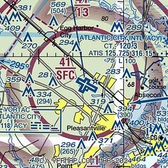
|
CAUTION: Diagram may not be current
 Download PDF
of official airport diagram from the FAA
| Airport distance calculator |
|---|
|
|
| Sunrise and sunset |
|---|
|
Times for 23-Apr-2024
| | Local
(UTC-4) | | Zulu
(UTC) |
|---|
| Morning civil twilight | | 05:41 | | 09:41 |
| Sunrise | | 06:09 | | 10:09 |
| Sunset | | 19:44 | | 23:44 |
| Evening civil twilight | | 20:12 | | 00:12 |
|
| Current date and time |
|---|
| Zulu (UTC) | 23-Apr-2024 16:48:34 |
|---|
| Local (UTC-4) | 23-Apr-2024 12:48:34 |
|---|
|
| METAR |
|---|
| KACY | 231554Z 15012G17KT 10SM CLR 16/00 A3017 RMK AO2 SLP215 T01560000
|
|
| TAF |
|---|
| KACY | 231120Z 2312/2412 17005KT P6SM FEW250 FM231500 16007KT P6SM FEW250
|
|
| NOTAMs |
|---|
NOTAMs are issued by the DoD/FAA and will open in a separate window not controlled by AirNav.
|
|


