FAA INFORMATION EFFECTIVE 18 APRIL 2024
Location
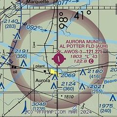
| FAA Identifier: | AUH |
| Lat/Long: | 40-53-38.9000N 097-59-40.4000W
40-53.648333N 097-59.673333W
40.8941389,-97.9945556
(estimated) |
| Elevation: | 1803.4 ft. / 549.7 m (surveyed) |
| Variation: | 06E (2000) |
| From city: | 2 miles N of AURORA, NE |
| Time zone: | UTC -5 (UTC -6 during Standard Time) |
| Zip code: | 68818 |
Airport Operations
| Airport use: | Open to the public |
| Activation date: | 09/1969 |
| Control tower: | no |
| ARTCC: | MINNEAPOLIS CENTER |
| FSS: | COLUMBUS FLIGHT SERVICE STATION |
| NOTAMs facility: | AUH (NOTAM-D service available) |
| Attendance: | MON-FRI 0800-1700 |
| Wind indicator: | lighted |
| Segmented circle: | no |
| Lights: | ACTVT MIRL RY 16/34 - CTAF. |
| Beacon: | white-green (lighted land airport)
Operates sunset to sunrise. |
Airport Communications
| CTAF/UNICOM: | 122.8 |
| WX AWOS-3: | 121.225 (402-694-5472) |
| WX ASOS at GRI (15 nm W): | PHONE 308-382-5590 |
| WX AWOS-3 at JYR (17 nm E): | 124.175 (402-362-3785) |
- APCH/DEP SVC PRVDD BY MINNEAPOLIS ARTCC ON FREQS 119.4/278.8 (HASTINGS RCAG).
Nearby radio navigation aids
| VOR radial/distance | | VOR name | | Freq | | Var |
|---|
| GRIr103/15.5 | | GRAND ISLAND VOR/DME | | 112.00 | | 07E |
| HSIr042/26.3 | | HASTINGS VOR/DME | | 108.80 | | 07E |
| NDB name | | Hdg/Dist | | Freq | | Var | | ID |
|---|
| YORK | | 263/17.1 | | 257 | | 06E | | JYR | .--- -.-- .-. |
| BEKLOF | | 306/26.6 | | 392 | | 07E | | FMZ | ..-. -- --.. |
Airport Services
| Fuel available: | 100LL
100LL:SELF SERVE FUEL AVBL 24/7 WITH CREDIT CARD. |
| Parking: | hangars and tiedowns |
| Airframe service: | MAJOR |
| Powerplant service: | NONE |
| Bottled oxygen: | NONE |
| Bulk oxygen: | NONE |
Runway Information
Runway 16/34
| Dimensions: | 4301 x 75 ft. / 1311 x 23 m |
| Surface: | concrete, in excellent condition |
| Weight bearing capacity: | |
| Runway edge lights: | medium intensity |
| RUNWAY 16 | | RUNWAY 34 |
| Latitude: | 40-53.995245N | | 40-53.300605N |
| Longitude: | 097-59.763500W | | 097-59.581815W |
| Elevation: | 1803.2 ft. | | 1796.9 ft. |
| Traffic pattern: | left | | left |
| Runway heading: | 163 magnetic, 169 true | | 343 magnetic, 349 true |
| Markings: | nonprecision, in good condition | | nonprecision, in good condition |
| Visual slope indicator: | 2-light PAPI on left (3.00 degrees glide path) | | 2-light PAPI on left (3.00 degrees glide path) |
| Touchdown point: | yes, no lights | | yes, no lights |
| Obstructions: | 42 ft. pline, 1219 ft. from runway, 337 ft. right of centerline, 24:1 slope to clear | | 9 ft. road, 457 ft. from runway, 28:1 slope to clear |
Airport Ownership and Management from official FAA records
| Ownership: | Publicly-owned |
| Owner: | AURORA AIRPORT AUTHORITY
1406 NORTH HIGHWAY 14
AURORA, NE 68818-1153
Phone 402-694-3633
JOHN WILCOX CHAIRMAN, PHONE 402-694-3633 (AIRPORT PHONE) |
| Manager: | TERRY OTT
1406 N HWY 14, 1406 NORTH HWY 14
AURORA, NE 68818-1153
Phone 402-694-3633 |
Airport Operational Statistics
| Aircraft based on the field: | | 18 | | Single engine airplanes: | | 18 |
- ULTRALIGHTS ON & INVOF ARPT.
| |  | |
| Aircraft operations: avg 56/day * | | 75% | local general aviation | | 24% | transient general aviation | | <1% | military | | * for 12-month period ending 27 July 2021 | |
Additional Remarks
| - | COURTESY CAR & ACFT PAINT SHOP AVBL. |
| - | FOR CD CTC MINNEAPOLIS ARTCC AT 651-463-5588. |
Instrument Procedures
NOTE: All procedures below are presented as PDF files. If you need a reader for these files, you should download the free Adobe Reader.NOT FOR NAVIGATION. Please procure official charts for flight.
FAA instrument procedures published for use from 18 April 2024 at 0901Z to 16 May 2024 at 0900Z.
IAPs - Instrument Approach Procedures |
|---|
| RNAV (GPS) RWY 16 | |
download (241KB) |
| RNAV (GPS) RWY 34 | |
download (213KB) |
| VOR-A | |
download (174KB) |
| NOTE: Special Alternate Minimums apply | |
download (23KB) |
| NOTE: Special Take-Off Minimums/Departure Procedures apply | |
download (147KB) |
Other nearby airports with instrument procedures:
07K - Central City Municipal Airport/Larry Reineke Field (13 nm N)
KGRI - Central Nebraska Regional Airport (15 nm W)
08K - Harvard State Airport (15 nm S)
KJYR - York Municipal Airport (17 nm E)
KHSI - Hastings Municipal Airport (26 nm SW)
|
|

Road maps at:
MapQuest
Bing
Google
| Aerial photo |
|---|

|
| Sectional chart |
|---|
|
| Airport distance calculator |
|---|
|
|
| Sunrise and sunset |
|---|
|
Times for 24-Apr-2024
| | Local
(UTC-5) | | Zulu
(UTC) |
|---|
| Morning civil twilight | | 06:10 | | 11:10 |
| Sunrise | | 06:39 | | 11:39 |
| Sunset | | 20:21 | | 01:21 |
| Evening civil twilight | | 20:50 | | 01:50 |
|
| Current date and time |
|---|
| Zulu (UTC) | 24-Apr-2024 23:31:13 |
|---|
| Local (UTC-5) | 24-Apr-2024 18:31:13 |
|---|
|
| METAR |
|---|
| KAUH | 242315Z AUTO 15012G18KT 10SM OVC110 19/00 A3008 RMK AO2 T01921002
|
KGRI
15nm W | 242253Z 14011KT 10SM BKN120 20/00 A3007 RMK AO2 SLP188 T02000000
|
|
| TAF |
|---|
KGRI
15nm W | 241730Z 2418/2518 13008KT P6SM BKN150 FM242000 15010G18KT P6SM SCT150 FM250100 15010KT P6SM BKN080 FM251400 15012KT P6SM BKN030
|
|
| NOTAMs |
|---|
NOTAMs are issued by the DoD/FAA and will open in a separate window not controlled by AirNav.
|
|

