FAA INFORMATION EFFECTIVE 21 MARCH 2024
Location
| FAA Identifier: | BEH |
| Lat/Long: | 42-07-42.1710N 086-25-29.5720W
42-07.702850N 086-25.492867W
42.1283808,-86.4248811
(estimated) |
| Elevation: | 649.1 ft. / 197.8 m (surveyed) |
| Variation: | 04W (2010) |
| From city: | 2 miles NE of BENTON HARBOR, MI |
| Time zone: | UTC -4 (UTC -5 during Standard Time) |
| Zip code: | 49022 |
Airport Operations
| Airport use: | Open to the public |
| Activation date: | 04/1940 |
| Control tower: | no |
| ARTCC: | CHICAGO CENTER |
| FSS: | LANSING FLIGHT SERVICE STATION |
| NOTAMs facility: | BEH (NOTAM-D service available) |
| Attendance: | MON-FRI 0800-1700, ALL SAT-SUN ON CALL
CALL 269-925-5114 DURG BUS HRS TO REQ AFT HRS SVC SUBJ CALL-IN FEE. UNATNDD MAJOR HOLS. |
| Wind indicator: | lighted |
| Segmented circle: | yes |
| Lights: | ACTVT MALSR RWY 28; REIL RWY 10, 14, & 32; PAPI RWY 10, 28, 14, & 32; HIRL RWY 10/28; MIRL RWY 14/32 - CTAF. |
| Beacon: | white-green (lighted land airport)
Operates sunset to sunrise. |
| Landing fee: | yes, LDG FEE FOR ALL COML OPS & ALL TURBINE PWRD ACFT; FAC FEE FOR ALL MULT ENG & COML SNGL ENG ACFT WAIVED WITH MNM FUEL PURCHASE. |
Airport Communications
| CTAF/UNICOM: | 123.0 |
| WX ASOS: | 121.55 (269-925-9008) |
| SOUTH BEND APPROACH: | 118.55 |
| SOUTH BEND DEPARTURE: | 118.55 |
| CLEARANCE DELIVERY: | 119.7 |
| WX AWOS-3 at LWA (15 nm NE): | 118.025 (269-637-7016) |
- DURING TMPRY CLOSURE OF ATCT BCST POSITION & INTETIONS ON FREQ 125.5.
- APCH/DEP SVC PRVDD BY CHICAGO ARTCC ON 127.55/307.175 (GOSHEN RCAG) WHEN SOUTH BEND APCH CTL CLSD.
Nearby radio navigation aids
| VOR radial/distance | | VOR name | | Freq | | Var |
|---|
| ELXr266/13.5 | | KEELER VOR/DME | | 116.60 | | 00E |
| GIJr348/22.1 | | GIPPER VORTAC | | 115.40 | | 00E |
| PMMr215/24.7 | | PULLMAN VOR/DME | | 112.10 | | 00E |
Airport Services
| Fuel available: | 100LL JET-A1+
100LL:AVBL H24 SELF SVC & FULL SVC DURG ATNDD HRS.
A1+:FOR SVC AFT HRS CALL 269-325-7529 SUBJ CALL-IN FEE. |
| Parking: | hangars and tiedowns |
| Airframe service: | MAJOR |
| Powerplant service: | MAJOR |
| Bottled oxygen: | HIGH/LOW |
| Bulk oxygen: | HIGH/LOW |
Runway Information
Runway 10/28
| Dimensions: | 6006 x 100 ft. / 1831 x 30 m |
| Surface: | asphalt/grooved, in good condition |
| Weight bearing capacity: | | Single wheel: | 60.0 | | Double wheel: | 100.0 | | Double tandem: | 100.0 |
|
| Runway edge lights: | high intensity |
| RUNWAY 10 | | RUNWAY 28 |
| Latitude: | 42-07.675410N | | 42-07.667502N |
| Longitude: | 086-26.030105W | | 086-24.701893W |
| Elevation: | 627.5 ft. | | 649.1 ft. |
| Traffic pattern: | left | | left |
| Runway heading: | 094 magnetic, 090 true | | 274 magnetic, 270 true |
| Markings: | precision, in good condition | | precision, in good condition |
| Visual slope indicator: | 4-light PAPI on left (3.00 degrees glide path) | | 4-light PAPI on left (3.00 degrees glide path) |
| Approach lights: | | | MALSR: 1,400 foot medium intensity approach lighting system with runway alignment indicator lights |
| Runway end identifier lights: | yes | | |
| Touchdown point: | yes, no lights | | yes, no lights |
| Instrument approach: | | | ILS/DME |
| Obstructions: | none | | 105 ft. trees, 3881 ft. from runway, 976 ft. right of centerline, 34:1 slope to clear |
Runway 14/32
| Dimensions: | 3205 x 60 ft. / 977 x 18 m |
| Surface: | asphalt, in fair condition |
| Weight bearing capacity: | | Single wheel: | 30.0 | | Double wheel: | 45.0 |
|
| Runway edge lights: | medium intensity |
| RUNWAY 14 | | RUNWAY 32 |
| Latitude: | 42-07.937405N | | 42-07.585807N |
| Longitude: | 086-25.994907W | | 086-25.466353W |
| Elevation: | 627.0 ft. | | 631.2 ft. |
| Traffic pattern: | left | | left |
| Runway heading: | 136 magnetic, 132 true | | 316 magnetic, 312 true |
| Markings: | basic, in good condition | | basic, in good condition |
| Visual slope indicator: | 2-light PAPI on left (3.50 degrees glide path) | | 2-light PAPI on left (3.50 degrees glide path) |
| Runway end identifier lights: | yes | | yes |
| Touchdown point: | yes, no lights | | yes, no lights |
| Obstructions: | none | | 83 ft. tree, 1601 ft. from runway, 244 ft. right of centerline, 16:1 slope to clear |
Airport Ownership and Management from official FAA records
| Ownership: | Publicly-owned |
| Owner: | BENTON HARBOR/ST JOSEPH
1123 TERRITORIAL RD
BENTON HARBOR, MI 49022-2939
Phone 269-927-3194 |
| Manager: | VINCENT DESJARDINS
1123 TERRITORIAL RD
BENTON HARBOR, MI 49022-2939
Phone 269-927-3194
EXTN 10; CELL 269-921-9200. |
Airport Operational Statistics
| Aircraft based on the field: | | 60 | | Single engine airplanes: | | 48 | | Multi engine airplanes: | | 5 | | Jet airplanes: | | 7 |
| |  | |
| Aircraft operations: avg 50/day * | | 47% | transient general aviation | | 47% | local general aviation | | 5% | air taxi | | <1% | military | | * for 12-month period ending 31 December 2021 | |
Additional Remarks
| - | BIRDS & DEER ON & INVOF ARPT. |
| - | FOR FLD CONDS CALL 269-369-2213, UNMON AFT ATNDD HRS. |
| - | FOR CD IF UNA VIA FREQ CTC SOUTH BEND APCH AT 574-251-2609. WHEN SOUTH BEND APCH CLSD, FOR CD CTC CHICAGO ARTCC AT 630-906-8921. |
| - | RWY 14 DROP OFF BEGINS 90 FT FM PAVED SFC. |
| - | SNOW REMOVAL OPS DURG WINTER MONTHS, VEHICLE OPRS MNT CTAF. |
| - | (CONTACT PHONE NR) CELL. |
Instrument Procedures
NOTE: All procedures below are presented as PDF files. If you need a reader for these files, you should download the free Adobe Reader.NOT FOR NAVIGATION. Please procure official charts for flight.
FAA instrument procedures published for use from 21 March 2024 at 0901Z to 18 April 2024 at 0900z.
IAPs - Instrument Approach Procedures |
|---|
| ILS OR LOC RWY 28 | |
download (219KB) |
| RNAV (GPS) RWY 10 | |
download (228KB) |
| RNAV (GPS) RWY 28 | |
download (204KB) |
| VOR RWY 28 | |
download (243KB) |
| NOTE: Special Alternate Minimums apply | |
download (65KB) |
| NOTE: Special Take-Off Minimums/Departure Procedures apply | |
download (347KB) |
Other nearby airports with instrument procedures:
C20 - Andrews University Airpark (11 nm S)
KLWA - South Haven Area Regional Airport (15 nm NE)
C91 - Dowagiac Municipal Airport (16 nm SE)
3TR - Jerry Tyler Memorial Airport (20 nm SE)
KSBN - South Bend International Airport (26 nm S)
|
|

Road maps at:
MapQuest
Bing
Google
| Aerial photo |
|---|
WARNING: Photo may not be current or correct
 Photo by Kevin Jarchow, West Michigan Wealth Management, LLC.
Photo taken 19-Jun-2013
looking east from about 6500 ft MSL.
Photo by Kevin Jarchow, West Michigan Wealth Management, LLC.
Photo taken 19-Jun-2013
looking east from about 6500 ft MSL.
Do you have a better or more recent aerial photo of Southwest Michigan Regional Airport that you would like to share? If so, please send us your photo.
|
| Sectional chart |
|---|
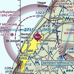
|
| Airport distance calculator |
|---|
|
|
| Sunrise and sunset |
|---|
|
Times for 16-Apr-2024
| | Local
(UTC-4) | | Zulu
(UTC) |
|---|
| Morning civil twilight | | 06:34 | | 10:34 |
| Sunrise | | 07:03 | | 11:03 |
| Sunset | | 20:28 | | 00:28 |
| Evening civil twilight | | 20:57 | | 00:57 |
|
| Current date and time |
|---|
| Zulu (UTC) | 16-Apr-2024 07:29:03 |
|---|
| Local (UTC-4) | 16-Apr-2024 03:29:03 |
|---|
|
| METAR |
|---|
| KBEH | 160653Z AUTO 06008KT 10SM CLR 13/01 A3007 RMK AO2 SLP182 T01280006
|
KLWA
15nm NE | 160715Z AUTO 07004KT 10SM CLR 10/00 A3008 RMK AO2 T01030000
|
|
| TAF |
|---|
KSBN
26nm S | 160527Z 1606/1706 06006KT P6SM SCT250 FM161500 12015G23KT P6SM BKN070 FM170300 14019G26KT P6SM VCSH BKN100
|
|
| NOTAMs |
|---|
NOTAMs are issued by the DoD/FAA and will open in a separate window not controlled by AirNav.
|
|

