FAA INFORMATION EFFECTIVE 18 APRIL 2024
Location
| FAA Identifier: | BMT |
| Lat/Long: | 30-04-12.7358N 094-12-54.3482W
30-04.212263N 094-12.905803W
30.0702044,-94.2150967
(estimated) |
| Elevation: | 31.9 ft. / 9.7 m (surveyed) |
| Variation: | 04E (2000) |
| From city: | 6 miles W of BEAUMONT, TX |
| Time zone: | UTC -5 (UTC -6 during Standard Time) |
| Zip code: | 77713 |
Airport Operations
| Airport use: | Open to the public |
| Activation date: | 10/1937 |
| Control tower: | no |
| ARTCC: | HOUSTON CENTER |
| FSS: | MONTGOMERY COUNTY FLIGHT SERVICE STATION |
| NOTAMs facility: | CXO (NOTAM-D service available) |
| Attendance: | 0700-1900 |
| Wind indicator: | lighted |
| Segmented circle: | yes |
| Lights: | DUSK-DAWN. MIRL RWY 13/31 PRESET LOW INTST; TO INCR INTST ACTVT - CTAF. |
| Beacon: | white-green (lighted land airport)
Operates sunset to sunrise. |
Airport Communications
| CTAF/UNICOM: | 123.0 |
| WX AWOS-3PT: | 118.425 (409-866-2832) |
| HOUSTON APPROACH: | 121.3 |
| HOUSTON DEPARTURE: | 121.3 |
| CLEARANCE DELIVERY: | 121.75 |
| WX ASOS at BPT (12 nm SE): | 126.3 (409-722-9396) |
Nearby radio navigation aids
| VOR radial/distance | | VOR name | | Freq | | Var |
|---|
| DASr103/23.4 | | DAISETTA VORTAC | | 116.90 | | 05E |
| SBIr331/24.8 | | SABINE PASS VOR/DME | | 115.40 | | 07E |
| NDB name | | Hdg/Dist | | Freq | | Var | | ID |
|---|
| GOODHUE | | at field | | 368 | | 07E | | GDE | --. -.. . |
Airport Services
| Fuel available: | 100LL JET-A
100LL:100LL AVBL 24 HRS SELF SVC. |
| Parking: | hangars and tiedowns |
| Airframe service: | MAJOR |
| Powerplant service: | MAJOR |
| Bulk oxygen: | NONE |
Runway Information
Runway 13/31
| Dimensions: | 4001 x 75 ft. / 1220 x 23 m |
| Surface: | asphalt, in excellent condition |
| Weight bearing capacity: | |
| Runway edge lights: | medium intensity |
| RUNWAY 13 | | RUNWAY 31 |
| Latitude: | 30-04.463430N | | 30-04.019023N |
| Longitude: | 094-13.231392W | | 094-12.670308W |
| Elevation: | 28.8 ft. | | 31.4 ft. |
| Traffic pattern: | right | | left |
| Runway heading: | 128 magnetic, 132 true | | 308 magnetic, 312 true |
| Displaced threshold: | 332 ft. | | 67 ft. |
| Markings: | nonprecision, in good condition | | nonprecision, in good condition |
| Visual slope indicator: | 4-light PAPI on left (3.00 degrees glide path) | | 4-light PAPI on left (4.00 degrees glide path) |
| Runway end identifier lights: | yes | | |
| Touchdown point: | yes, no lights | | yes, no lights |
| Obstructions: | 45 ft. pline, 745 ft. from runway, 300 ft. left of centerline, 12:1 slope to clear
APCH SLOPE 23:1 TO DSPLCD THR. | | 15 ft. road, 350 ft. from runway, 260 ft. right of centerline, 10:1 slope to clear
APCH SLOPE 16:1 TO DSPLCD THR OVR 54 FT TREE, 900 FT DSTC. |
Airport Ownership and Management from official FAA records
| Ownership: | Publicly-owned |
| Owner: | CITY OF BEAUMONT
PO BOX 3827
BEAUMONT, TX 77704
Phone 409-880-3725 |
| Manager: | CHRIS MEAUX
455 KEITH RD
BEAUMONT, TX 77713
Phone 409-866-0084
AMGR CELL 409-679-0222 |
Airport Operational Statistics
| Aircraft based on the field: | | 46 | | Single engine airplanes: | | 38 | | Multi engine airplanes: | | 5 | | Jet airplanes: | | 1 | | Helicopters: | | 2 |
| |  | |
| Aircraft operations: avg 42/day * | | 80% | local general aviation | | 15% | transient general aviation | | 3% | military | | 2% | air taxi | | * for 12-month period ending 04 April 2023 | |
Additional Remarks
| - | DEER ON AND INVOF ARPT. |
| - | FOR CD CTC HOUSTON APCH AT 281-443-5844. TO CNL IFR CTC HOUSTON APCH AT 281-443-5888. |
Instrument Procedures
NOTE: All procedures below are presented as PDF files. If you need a reader for these files, you should download the free Adobe Reader.NOT FOR NAVIGATION. Please procure official charts for flight.
FAA instrument procedures published for use from 18 April 2024 at 0901Z to 16 May 2024 at 0900Z.
IAPs - Instrument Approach Procedures |
|---|
| RNAV (GPS) RWY 13 | |
download (222KB) |
| RNAV (GPS) RWY 31 **CHANGED** | |
download (179KB) |
| NOTE: Special Alternate Minimums apply **CHANGED** | |
download (147KB) |
| NOTE: Special Take-Off Minimums/Departure Procedures apply | |
download (70KB) |
Other nearby airports with instrument procedures:
KBPT - Jack Brooks Regional Airport (12 nm SE)
45R - Hawthorne Field Airport (16 nm N)
T90 - Chambers County/Winnie Stowell Airport (19 nm SW)
KORG - Orange County Airport (21 nm E)
T78 - Liberty Municipal Airport (25 nm W)
|
|

Road maps at:
MapQuest
Bing
Google
| Aerial photo |
|---|
WARNING: Photo may not be current or correct

Do you have a better or more recent aerial photo of Beaumont Municipal Airport that you would like to share? If so, please send us your photo.
|
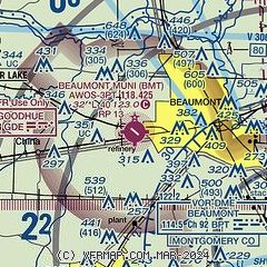
| Sectional chart |
|---|
|
CAUTION: Diagram may not be current

| Airport distance calculator |
|---|
|
|
| Sunrise and sunset |
|---|
|
Times for 23-Apr-2024
| | Local
(UTC-5) | | Zulu
(UTC) |
|---|
| Morning civil twilight | | 06:16 | | 11:16 |
| Sunrise | | 06:41 | | 11:41 |
| Sunset | | 19:49 | | 00:49 |
| Evening civil twilight | | 20:14 | | 01:14 |
|
| Current date and time |
|---|
| Zulu (UTC) | 23-Apr-2024 15:07:50 |
|---|
| Local (UTC-5) | 23-Apr-2024 10:07:50 |
|---|
|
| METAR |
|---|
| KBMT | 231455Z AUTO 16006KT 10SM CLR 21/12 A3015 RMK AO2 T02120122
|
KBPT
12nm SE | 231453Z 17009KT 10SM CLR 22/13 A3013 RMK AO2 SLP204 T02170128 53009 $
|
|
| TAF |
|---|
KBPT
12nm SE | 231132Z 2312/2412 VRB04KT P6SM FEW250 FM231400 14006KT P6SM SKC FM231700 17011KT P6SM FEW100 FM240100 17004KT P6SM BKN050
|
|
| NOTAMs |
|---|
NOTAMs are issued by the DoD/FAA and will open in a separate window not controlled by AirNav.
|
|


