FAA INFORMATION EFFECTIVE 21 MARCH 2024
Location
| FAA Identifier: | BST |
| Lat/Long: | 44-24-33.8000N 069-00-42.6000W
44-24.563333N 069-00.710000W
44.4093889,-69.0118333
(estimated) |
| Elevation: | 197.6 ft. / 60.2 m (surveyed) |
| Variation: | 18W (2000) |
| From city: | 1 mile SW of BELFAST, ME |
| Time zone: | UTC -4 (UTC -5 during Standard Time) |
| Zip code: | 04915 |
Airport Operations
| Airport use: | Open to the public |
| Activation date: | 03/1943 |
| Control tower: | no |
| ARTCC: | BOSTON CENTER |
| FSS: | BANGOR FLIGHT SERVICE STATION |
| NOTAMs facility: | BGR (NOTAM-D service available) |
| Attendance: | IREG |
| Wind indicator: | lighted |
| Segmented circle: | yes |
| Lights: | ACTVT REIL RWY 15 & 33; MIRL RWY 15/33 - CTAF. |
| Beacon: | white-green (lighted land airport)
Operates sunset to sunrise. |
Airport Communications
| CTAF/UNICOM: | 122.975 |
| WX AWOS-AV: | 122.975 (207-930-7071) |
| BANGOR APPROACH: | 118.925 |
| BANGOR DEPARTURE: | 118.925 |
Nearby radio navigation aids
| VOR radial/distance | | VOR name | | Freq | | Var |
|---|
| BGRr212/26.6 | | BANGOR VORTAC | | 114.80 | | 19W |
| AUGr099/34.1 | | AUGUSTA VOR/DME | | 114.95 | | 18W |
| NDB name | | Hdg/Dist | | Freq | | Var | | ID |
|---|
| BURNHAM | | 157/22.8 | | 348 | | 18W | | BUP | -... ..- .--. |
Airport Services
| Fuel available: | 100LL JET-A+ |
| Parking: | hangars and tiedowns |
| Airframe service: | NONE |
| Powerplant service: | NONE |
| Bottled oxygen: | NONE |
| Bulk oxygen: | NONE |
Runway Information
Runway 15/33
| Dimensions: | 4000 x 100 ft. / 1219 x 30 m |
| Surface: | asphalt, in good condition |
| Weight bearing capacity: | |
| Runway edge lights: | medium intensity |
| RUNWAY 15 | | RUNWAY 33 |
| Latitude: | 44-24.789857N | | 44-24.337253N |
| Longitude: | 069-01.043273W | | 069-00.376365W |
| Elevation: | 197.5 ft. | | 158.5 ft. |
| Traffic pattern: | left | | left |
| Runway heading: | 151 magnetic, 133 true | | 331 magnetic, 313 true |
| Markings: | nonprecision, in good condition | | nonprecision, in good condition |
| Runway end identifier lights: | yes | | yes |
| Touchdown point: | yes, no lights | | yes, no lights |
| Obstructions: | 10 ft. tree, 213 ft. from runway, 150 ft. left of centerline, 1:1 slope to clear
8 FT BRUSH 140-200 FT FM THR, 75-250 FT R OF CNTRLN; 4-10 FT BRUSH 60-200 FT FM THR, 200-250 FT L OF CNTRLN. | | 18 ft. tree, 330 ft. from runway, 220 ft. right of centerline, 7:1 slope to clear
4-8 FT BRUSH 30-200 FT FM THR, 90-200 FT R OF CNTRLN. |
Airport Ownership and Management from official FAA records
| Ownership: | Publicly-owned |
| Owner: | CITY OF BELFAST
CITY HALL, 131 CHURCH ST
BELFAST, ME 04915
Phone 207-338-3370X600 |
| Manager: | KENN ORTMANN
22 WRIGHT BROTHERS DR
BELFAST, ME 04915
Phone 603-970-1947
SEND ALL MGR CORRESPONDANCE TO CITY HALL 131 CHURCH ST. BELFAST, ME 04915. |
Airport Operational Statistics
| Aircraft based on the field: | | 27 | | Single engine airplanes: | | 27 |
| |  | |
| Aircraft operations: avg 61/week * | | 62% | local general aviation | | 22% | transient general aviation | | 16% | air taxi | | * for 12-month period ending 31 December 2023 | |
Additional Remarks
| - | FOR CD CTC BANGOR APCH AT 207-561-2500 EXT 1. |
| - | 800 FT X 30 FT PARL TURF LDG AREA E OF RWY & N OF TWY B - AMGR. |
| - | FAA WX CAMERA INFO AVBL AT HTTPS://WEATHERCAMS.FAA.GOV/MAP/-69.61024,44.01514,-67.21384,44.80289/CAMERASITE/600/DETAILS/CAMERA. |
| - | AWOS AVBL - CTAF 2 CLICKS OR 207-930-7071. |
| - | DEER & BIRDS ON & INVOF ARPT. |
| - | SFC COND RPRTD DAILY 1400-2200Z DEC-MAR. |
Instrument Procedures
NOTE: All procedures below are presented as PDF files. If you need a reader for these files, you should download the free Adobe Reader.NOT FOR NAVIGATION. Please procure official charts for flight.
FAA instrument procedures published for use from 21 March 2024 at 0901Z to 18 April 2024 at 0900z.
IAPs - Instrument Approach Procedures |
|---|
| RNAV (GPS) RWY 15 | |
download (255KB) |
| RNAV (GPS) RWY 33 | |
download (285KB) |
| NOTE: Special Take-Off Minimums/Departure Procedures apply | |
download (178KB) |
Other nearby airports with instrument procedures:
KRKD - Knox County Regional Airport (21 nm S)
KBGR - Bangor International Airport (25 nm N)
2B7 - Pittsfield Municipal Airport (27 nm NW)
KBHB - Hancock County/Bar Harbor Airport (28 nm E)
KWVL - Waterville Robert LaFleur Airport (29 nm W)
|
|

Road maps at:
MapQuest
Bing
Google
| Aerial photo |
|---|
WARNING: Photo may not be current or correct
 Photo by Kyle Warren Photography
Photo taken 20-Feb-2017
looking northwest.
Photo by Kyle Warren Photography
Photo taken 20-Feb-2017
looking northwest.
Do you have a better or more recent aerial photo of Belfast Municipal Airport that you would like to share? If so, please send us your photo.
|
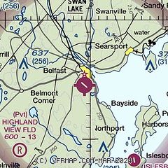
| Sectional chart |
|---|
|
| Airport distance calculator |
|---|
|
|
| Sunrise and sunset |
|---|
|
Times for 16-Apr-2024
| | Local
(UTC-4) | | Zulu
(UTC) |
|---|
| Morning civil twilight | | 05:19 | | 09:19 |
| Sunrise | | 05:50 | | 09:50 |
| Sunset | | 19:22 | | 23:22 |
| Evening civil twilight | | 19:52 | | 23:52 |
|
| Current date and time |
|---|
| Zulu (UTC) | 16-Apr-2024 21:06:23 |
|---|
| Local (UTC-4) | 16-Apr-2024 17:06:23 |
|---|
|
| METAR |
|---|
KRKD
21nm S | 162056Z AUTO VRB05KT 10SM OVC085 16/01 A3001 RMK AO2 SLP162 T01560011 52007
|
KBGR
25nm N | 162053Z 32014KT 10SM BKN060 12/M01 A3004 RMK AO2 PK WND 34026/2034 SLP172 T01221011 53012
|
KBHB
28nm E | 162056Z AUTO 34011G22KT 300V360 10SM SCT065 13/00 A3001 RMK AO2 SLP165 T01330000 53011
|
KWVL
29nm W | 162056Z AUTO 33010G18KT 10SM SCT075 13/M01 A3002 RMK AO2 SLP193 T01281006 53008
|
KAUG
34nm W | 162053Z AUTO 32009G21KT 10SM BKN075 14/00 A3003 RMK AO2 SLP169 T01440000 52007
|
KIWI
40nm SW | 162053Z AUTO VRB03KT 10SM BKN080 OVC090 16/00 A3002 RMK AO2 SLP164 T01610000 51005
|
|
| TAF |
|---|
KRKD
21nm S | 161721Z 1618/1718 29012G20KT P6SM SCT060 FM162300 32008KT P6SM FEW070 FM171500 29009KT P6SM SKC
|
KBGR
25nm N | 161905Z 1619/1718 30010G18KT P6SM BKN050 FM162300 31008KT P6SM SCT050 FM171200 34010G18KT P6SM SCT050
|
|
| NOTAMs |
|---|
NOTAMs are issued by the DoD/FAA and will open in a separate window not controlled by AirNav.
|
|

