FAA INFORMATION EFFECTIVE 21 MARCH 2024
Location
| FAA Identifier: | C20 |
| Lat/Long: | 41-57-03.8000N 086-22-05.1000W
41-57.063333N 086-22.085000W
41.9510556,-86.3680833
(estimated) |
| Elevation: | 673.7 ft. / 205.3 m (surveyed) |
| Variation: | 03W (1985) |
| From city: | 2 miles W of BERRIEN SPRINGS, MI |
| Time zone: | UTC -4 (UTC -5 during Standard Time) |
| Zip code: | 49103 |
Airport Operations
| Airport use: | Open to the public |
| Activation date: | 07/1970 |
| Control tower: | no |
| ARTCC: | CHICAGO CENTER |
| FSS: | LANSING FLIGHT SERVICE STATION |
| NOTAMs facility: | LAN (NOTAM-D service available) |
| Attendance: | ALL/SAT, SUN/UNATNDD, ALL MON-THUR 0800-1700, ALL FRI 0800-1500 |
| Pattern altitude: | 1705.7 ft. MSL |
| Wind indicator: | yes |
| Segmented circle: | yes |
| Lights: | ACTVT NSTD LIRL RWY 13/31 - CTAF. |
| Beacon: | white-green (lighted land airport)
Operates sunset to sunrise. |
Airport Communications
| CTAF/UNICOM: | 122.7 |
| SOUTH BEND APPROACH: | 118.55 |
| SOUTH BEND DEPARTURE: | 118.55 |
| WX ASOS at BEH (11 nm N): | 121.55 (269-925-9008) |
| WX ASOS at SBN (15 nm S): | 120.675 (574-251-2652) |
- APCH/DEP SVC PRVDD BY CHICAGO ARTCC ON 127.55/307.175 (GOSHEN RCAG) WHEN SOUTH BEND APCH CTL CLSD.
Nearby radio navigation aids
| VOR radial/distance | | VOR name | | Freq | | Var |
|---|
| GIJr349/11.2 | | GIPPER VORTAC | | 115.40 | | 00E |
| ELXr223/15.9 | | KEELER VOR/DME | | 116.60 | | 00E |
| GSHr329/29.7 | | GOSHEN VORTAC | | 113.70 | | 00E |
| PMMr201/33.0 | | PULLMAN VOR/DME | | 112.10 | | 00E |
Airport Services
| Fuel available: | 100LL
100LL:AVBL H24 SELF SVC. |
| Parking: | hangars and tiedowns |
| Bottled oxygen: | NONE |
Runway Information
Runway 13/31
| Dimensions: | 4148 x 70 ft. / 1264 x 21 m |
| Surface: | asphalt, in fair condition |
| Runway edge lights: | non-standard
NSTD LIRL DUE TO LGTS LCTD 20 FT FM RWY EDGE & DTHR UNLGTD. |
| RUNWAY 13 | | RUNWAY 31 |
| Latitude: | 41-57.201913N | | 41-56.752205N |
| Longitude: | 086-22.369518W | | 086-21.680928W |
| Elevation: | 668.9 ft. | | 673.7 ft. |
| Traffic pattern: | right | | left |
| Runway heading: | 134 magnetic, 131 true | | 314 magnetic, 311 true |
| Displaced threshold: | no | | 1129 ft. |
| Markings: | precision, in good condition | | precision, in good condition |
| Runway end identifier lights: | no | | no |
| Touchdown point: | yes, no lights | | yes, no lights |
| Obstructions: | 70 ft. trees, 200 ft. from runway, 200 ft. left of centerline
6 FT DIRT MOUND, 0 FT DIST, 205 FT L. | | 90 ft. trees, 877 ft. from runway, 70 ft. left of centerline, 7:1 slope to clear
7 FT TREES, 199 FT DIST, 215 FT R. |
Runway 3/21
| Dimensions: | 2298 x 180 ft. / 700 x 55 m |
| Surface: | turf, in fair condition |
| RUNWAY 3 | | RUNWAY 21 |
| Latitude: | 41-57.047100N | | 41-57.388398N |
| Longitude: | 086-22.304210W | | 086-22.085428W |
| Elevation: | 666.9 ft. | | 662.8 ft. |
| Traffic pattern: | left | | right |
| Runway heading: | 029 magnetic, 026 true | | 209 magnetic, 206 true |
| Touchdown point: | yes, no lights | | yes, no lights |
| Obstructions: | 100 ft. trees, 300 ft. from runway, 3:1 slope to clear | | 70 ft. trees, 90 ft. from runway, 90 ft. right of centerline |
Airport Ownership and Management from official FAA records
| Ownership: | Privately-owned |
| Owner: | ANDREWS UNIVERSITY
4150 ADMINISTRATION DR
BERRIEN SPRINGS, MI 49104-1400
Phone 269-471-3265 |
| Manager: | DUANE HABENICHT
3898 GRIGGS AVE
BERRIEN SPRINGS, MI 49103-1675
Phone 269-930-0734
CELL. |
Airport Operational Statistics
| Aircraft based on the field: | | 31 | | Single engine airplanes: | | 30 | | Multi engine airplanes: | | 1 |
| |  | |
| Aircraft operations: avg 76/day * | | 90% | local general aviation | | 10% | transient general aviation | | * for 12-month period ending 12 September 2019 | |
Additional Remarks
| - | ADMIN BLDG ACES: PRESS V, THEN III & II SIMUL, THEN I. |
| - | BIRDS & DEER ON & INVOF ARPT. |
| - | RWY 13/31: 25 FT DROP OFF, 55 FT DIST FM NW END; 15 FT DROP OFF, 0-400 FT DIST FM SE END. |
| - | FOR CD CTC SOUTH BEND APCH AT 574-251-2609, WHEN APCH CLSD CTC CHICAGO ARTCC AT 630-906-8921. |
| - | UNVERIFIED LDG AREA LCTD NW OF PRI RWY, CTC AMGR FOR DTLS. |
Instrument Procedures
NOTE: All procedures below are presented as PDF files. If you need a reader for these files, you should download the free Adobe Reader.NOT FOR NAVIGATION. Please procure official charts for flight.
FAA instrument procedures published for use from 21 March 2024 at 0901Z to 18 April 2024 at 0900z.
IAPs - Instrument Approach Procedures |
|---|
| RNAV (GPS) RWY 13 | |
download (206KB) |
| RNAV (GPS) RWY 31 | |
download (212KB) |
| NOTE: Special Take-Off Minimums/Departure Procedures apply | |
download (122KB) |
Other nearby airports with instrument procedures:
3TR - Jerry Tyler Memorial Airport (9 nm SE)
KBEH - Southwest Michigan Regional Airport (11 nm N)
C91 - Dowagiac Municipal Airport (11 nm E)
KSBN - South Bend International Airport (15 nm S)
KEKM - Elkhart Municipal Airport (21 nm SE)
|
|

Road maps at:
MapQuest
Bing
Google
| Aerial photo |
|---|
WARNING: Photo may not be current or correct
 Photo taken 13-Mar-2008
Do you have a better or more recent aerial photo of Andrews University Airpark that you would like to share? If so, please send us your photo.
|
| Sectional chart |
|---|
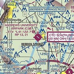
|
CAUTION: Diagram may not be current

| Airport distance calculator |
|---|
|
|
| Sunrise and sunset |
|---|
|
Times for 16-Apr-2024
| | Local
(UTC-4) | | Zulu
(UTC) |
|---|
| Morning civil twilight | | 06:34 | | 10:34 |
| Sunrise | | 07:03 | | 11:03 |
| Sunset | | 20:27 | | 00:27 |
| Evening civil twilight | | 20:56 | | 00:56 |
|
| Current date and time |
|---|
| Zulu (UTC) | 17-Apr-2024 02:01:36 |
|---|
| Local (UTC-4) | 16-Apr-2024 22:01:36 |
|---|
|
| METAR |
|---|
KBEH
11nm N | 170153Z AUTO 12016G25KT 10SM FEW120 21/07 A2979 RMK AO2 PK WND 10033/0110 PRESRR SLP085 T02060067
|
KSBN
15nm S | 170154Z 12012G22KT 10SM CLR 19/08 A2982 RMK AO2 PK WND 11030/0122 PRESRR SLP095 T01940078
|
KEKM
22nm SE | 170155Z AUTO 10014G27KT 8SM SCT140 17/06 A2981 RMK AO2 PK WND 10027/0150 T01750055 $
|
|
| TAF |
|---|
KSBN
15nm S | 161742Z 1618/1718 11014G26KT P6SM BKN050 FM170400 14016G24KT 6SM -SHRA BR VCTS OVC040CB FM170800 16013G19KT P6SM VCSH BKN025 FM171200 16014G25KT P6SM VCSH BKN035
|
|
| NOTAMs |
|---|
NOTAMs are issued by the DoD/FAA and will open in a separate window not controlled by AirNav.
|
|

