FAA INFORMATION EFFECTIVE 18 APRIL 2024
Location
| FAA Identifier: | CEC |
| Lat/Long: | 41-46-48.6000N 124-14-11.5000W
41-46.810000N 124-14.191667W
41.7801667,-124.2365278
(estimated) |
| Elevation: | 60.7 ft. / 18.5 m (surveyed) |
| Variation: | 14E (2020) |
| From city: | 3 miles NW of CRESCENT CITY, CA |
| Time zone: | UTC -7 (UTC -8 during Standard Time) |
| Zip code: | 95531 |
Airport Operations
| Airport use: | Open to the public |
| Activation date: | 08/1943 |
| Control tower: | no |
| ARTCC: | SEATTLE CENTER |
| FSS: | OAKLAND FLIGHT SERVICE STATION |
| NOTAMs facility: | CEC (NOTAM-D service available) |
| Attendance: | 0800-1800
OTR HRS FBO REQUIRES CALL OUT FEE. |
| Wind indicator: | lighted |
| Segmented circle: | yes |
| Lights: | ACTVT MALSR RWY 12; REIL RWY 18, 36, & 30; HIRL RWY 12/30; MIRL RWY 18/36 - CTAF. |
| Beacon: | white-green (lighted land airport)
Operates sunset to sunrise. |
| Fire and rescue: | ARFF index A |
| Airline operations: | PPR FOR UNSKED ACR OPNS WITH MORE THAN 30 PSGR SEATS CALL AMGR 707-464-7288 OR 707-465-3804. |
Airport Communications
| CTAF/UNICOM: | 122.8 |
| WX ASOS: | 119.925 (707-465-5458) |
| WX AWOS-3PT at BOK (18 nm N): | 132.025 (541-412-8682) |
- APCH/DEP CTL SVC PRVDD BY SEATTLE ARTCC (ZSE) ON FREQS 124.85/306.3 (ARCATA RCAG).
Nearby radio navigation aids
| VOR radial/distance | | VOR name | | Freq | | Var |
|---|
| CEC at field | | CRESCENT CITY VORTAC | | 109.00 | | 14E |
Airport Services
| Fuel available: | 100LL JET-A |
| Parking: | tiedowns |
| Airframe service: | MINOR |
| Powerplant service: | MINOR |
| Bottled oxygen: | NONE |
| Bulk oxygen: | NONE |
Runway Information
Runway 12/30
| Dimensions: | 5002 x 150 ft. / 1525 x 46 m |
| Surface: | asphalt, in fair condition |
| Weight bearing capacity: | | PCN 9 /F/D/Y/U | | Single wheel: | 30.0 | | Double wheel: | 43.0 |
|
| Runway edge lights: | high intensity |
| RUNWAY 12 | | RUNWAY 30 |
| Latitude: | 41-47.099597N | | 41-46.535947N |
| Longitude: | 124-14.492563W | | 124-13.690418W |
| Elevation: | 56.9 ft. | | 53.0 ft. |
| Traffic pattern: | left | | left |
| Runway heading: | 119 magnetic, 133 true | | 299 magnetic, 313 true |
| Declared distances: | TORA:5002 TODA:5002 ASDA:5002 LDA:5002 | | TORA:5002 TODA:5002 ASDA:5002 LDA:5002 |
| Markings: | precision, in fair condition | | precision, in fair condition |
| Visual slope indicator: | | | 4-box VASI on left (3.50 degrees glide path) |
| Approach lights: | MALSR: 1,400 foot medium intensity approach lighting system with runway alignment indicator lights | | |
| Runway end identifier lights: | no | | yes |
| Touchdown point: | yes, no lights | | yes, no lights |
| Instrument approach: | ILS | | |
| Obstructions: | none | | 86 ft. trees, 1520 ft. from runway, 250 ft. right of centerline, 15:1 slope to clear |
Runway 18/36
| Dimensions: | 5000 x 150 ft. / 1524 x 46 m |
| Surface: | asphalt, in fair condition |
| Weight bearing capacity: | | PCN 9 /F/D/Y/U | | Single wheel: | 30.0 | | Double wheel: | 43.0 |
|
| Runway edge lights: | medium intensity |
| RUNWAY 18 | | RUNWAY 36 |
| Latitude: | 41-47.203078N | | 41-46.401583N |
| Longitude: | 124-14.166725W | | 124-14.417913W |
| Elevation: | 60.6 ft. | | 50.6 ft. |
| Traffic pattern: | left | | left |
| Runway heading: | 179 magnetic, 193 true | | 359 magnetic, 013 true |
| Displaced threshold: | 148 ft. | | no |
| Declared distances: | TORA:5000 TODA:5000 ASDA:5000 LDA:4850 | | TORA:4850 TODA:4850 ASDA:4850 LDA:4850 |
| Markings: | nonprecision, in fair condition | | nonprecision, in fair condition |
| Visual slope indicator: | | | 4-box VASI on left (3.00 degrees glide path) |
| Runway end identifier lights: | yes | | yes |
| Touchdown point: | yes, no lights | | yes, no lights |
| Obstructions: | 55 ft. gnd, 1075 ft. from runway, 250 ft. right of centerline, 15:1 slope to clear | | 9 ft. road, 350 ft. from runway, 16:1 slope to clear |
Airport Ownership and Management from official FAA records
| Ownership: | Publicly-owned |
| Owner: | BORDER COAST REGIONAL ARPT AUTH
1650 DALE RUPERT ROAD, SUITE 100
CRESCENT CITY, CA 95531
Phone 707-464-7288 |
| Manager: | RYAN COOLEY
1650 DALE RUPERT RD, SUITE 100
CRESCENT CITY, CA 95531
Phone 707-464-7288 |
Airport Operational Statistics
| Aircraft based on the field: | | 16 | | Single engine airplanes: | | 13 | | Multi engine airplanes: | | 3 |
| |  | |
| Aircraft operations: avg 34/day * | | 49% | local general aviation | | 27% | air taxi | | 22% | transient general aviation | | 1% | military | | * for 12-month period ending 31 July 2019 | |
Additional Remarks
| - | A 150 FT LGTD TWR 3300 FT W CEC VOR. |
| - | BIRDS AND DEER ON & INVOF ARPT. |
| - | RIDGE LNS OF SHIFTING SAND DUNES 30-50 FT AGL AND 1000 FT OFF APCH END RWY 18. |
| - | TSNT PRKG RAMP ESTD WGT LIMIT 20000 LBS, FBO RAMP ESTD WGT LIMIT 60000 LBS. |
| - | FOR CD IF UNA TO CTC ON FSS FREQ, CTC SEATTLE ARTCC AT 253-351-3694. |
Instrument Procedures
NOTE: All procedures below are presented as PDF files. If you need a reader for these files, you should download the free Adobe Reader.NOT FOR NAVIGATION. Please procure official charts for flight.
FAA instrument procedures published for use from 18 April 2024 at 0901Z to 16 May 2024 at 0900Z.
IAPs - Instrument Approach Procedures |
|---|
| ILS OR LOC RWY 12 | |
download (399KB) |
| RNAV (GPS) RWY 12 | |
download (377KB) |
| RNAV (GPS) RWY 36 | |
download (361KB) |
| VOR/DME RWY 12 | |
download (418KB) |
| VOR/DME RWY 36 | |
download (366KB) |
| VOR RWY 12 | |
download (356KB) |
| NOTE: Special Alternate Minimums apply | |
download (133KB) |
| NOTE: Special Take-Off Minimums/Departure Procedures apply | |
download (348KB) |
Other nearby airports with instrument procedures:
KBOK - Brookings Airport (18 nm N)
4S1 - Gold Beach Municipal Airport (39 nm N)
KACV - California Redwood Coast-Humboldt County Airport (48 nm S)
3S8 - Grants Pass Airport (58 nm NE)
KEKA - Murray Field Airport (59 nm S)
|
|

Road maps at:
MapQuest
Bing
Google
| Aerial photo |
|---|
WARNING: Photo may not be current or correct
 Photo by Kenneth and Gabrielle Adelman
Photo taken 11-Oct-2019
looking northeast.
Photo by Kenneth and Gabrielle Adelman
Photo taken 11-Oct-2019
looking northeast.
Do you have a better or more recent aerial photo of Jack Mc Namara Field Airport that you would like to share? If so, please send us your photo.
|
| Sectional chart |
|---|
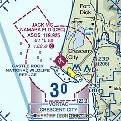
|
| Airport distance calculator |
|---|
|
|
| Sunrise and sunset |
|---|
|
Times for 18-Apr-2024
| | Local
(UTC-7) | | Zulu
(UTC) |
|---|
| Morning civil twilight | | 06:02 | | 13:02 |
| Sunrise | | 06:31 | | 13:31 |
| Sunset | | 20:01 | | 03:01 |
| Evening civil twilight | | 20:30 | | 03:30 |
|
| Current date and time |
|---|
| Zulu (UTC) | 18-Apr-2024 18:40:38 |
|---|
| Local (UTC-7) | 18-Apr-2024 11:40:38 |
|---|
|
| METAR |
|---|
| KCEC | 181756Z AUTO 34006KT 10SM CLR 14/07 A3000 RMK AO2 SLP160 T01440072 10150 20056 55000
|
KBOK
18nm N | 181756Z AUTO 29005KT 10SM CLR 17/01 A3001 RMK AO2 SLP161 6//// T01720006 10178 20144 50002
|
|
| TAF |
|---|
| KCEC | 181730Z 1818/1918 28007KT P6SM SKC FM182000 330011KT P6SM SCT200 FM190100 30006KT P6SM SCT200
|
|
| NOTAMs |
|---|
NOTAMs are issued by the DoD/FAA and will open in a separate window not controlled by AirNav.
|
|

