FAA INFORMATION EFFECTIVE 21 MARCH 2024
Location
| FAA Identifier: | CEU |
| Lat/Long: | 34-40-20.0000N 082-53-09.2000W
34-40.333333N 082-53.153333W
34.6722222,-82.8858889
(estimated) |
| Elevation: | 890.6 ft. / 271.5 m (surveyed) |
| Variation: | 05W (2000) |
| From city: | 3 miles W of CLEMSON, SC |
| Time zone: | UTC -4 (UTC -5 during Standard Time) |
| Zip code: | 29678 |
Airport Operations
| Airport use: | Open to the public |
| Control tower: | no |
| ARTCC: | ATLANTA CENTER |
| FSS: | ANDERSON FLIGHT SERVICE STATION |
| NOTAMs facility: | CEU (NOTAM-D service available) |
| Attendance: | MON-SAT 0800-1800, ALL SUN 0900-1700 |
| Wind indicator: | lighted |
| Segmented circle: | yes |
| Lights: | ACTVT REIL RWY 07 & 25; PAPI RWY 07 & 25; MIRL RWY 07/25 - CTAF. |
| Beacon: | white-green (lighted land airport)
Operates sunset to sunrise. |
Airport Communications
| CTAF/UNICOM: | 122.7 |
| WX ASOS: | 119.275 (864-653-8855) |
| GREER APPROACH: | 118.8 |
| GREER DEPARTURE: | 118.8 |
| WX AWOS-3 at LQK (12 nm NE): | 120.0 (864-843-5801) |
| WX ASOS at AND (14 nm SE): | 120.675 (864-226-9522) |
- APCH/DEP SVC PRVDD BY ATLANTA ARTCC ON FREQS 134.8/379.95 (MOUNT OGLETHORPE RCAG) WHEN APCH CTL CLSD.
Nearby radio navigation aids
| VOR radial/distance | | VOR name | | Freq | | Var |
|---|
| ELWr342/16.0 | | ELECTRIC CITY VORTAC | | 108.60 | | 00E |
| ODFr094/20.4 | | FOOTHILLS VOR/DME | | 113.40 | | 00E |
Airport Services
| Fuel available: | 100LL JET-A |
| Parking: | hangars and tiedowns |
| Airframe service: | MAJOR |
| Powerplant service: | MAJOR |
| Bottled oxygen: | NONE |
| Bulk oxygen: | NONE |
Runway Information
Runway 7/25
| Dimensions: | 5000 x 100 ft. / 1524 x 30 m |
| Surface: | asphalt, in good condition |
| Weight bearing capacity: | | PCN 10 /F/C/Y/T | | Single wheel: | 28.5 | | Double wheel: | 44.0 |
|
| Runway edge lights: | medium intensity |
| RUNWAY 7 | | RUNWAY 25 |
| Latitude: | 34-40.177680N | | 34-40.489537N |
| Longitude: | 082-53.615565W | | 082-52.692022W |
| Elevation: | 888.1 ft. | | 874.4 ft. |
| Traffic pattern: | right | | left |
| Runway heading: | 073 magnetic, 068 true | | 253 magnetic, 248 true |
| Markings: | nonprecision, in good condition | | nonprecision, in good condition |
| Visual slope indicator: | 2-light PAPI on left (3.00 degrees glide path) | | 2-light PAPI on left (3.00 degrees glide path) |
| Runway end identifier lights: | yes | | yes |
| Touchdown point: | yes, no lights | | yes, no lights |
| Obstructions: | 95 ft. tree, 1756 ft. from runway, 652 ft. right of centerline, 16:1 slope to clear | | 30 ft. tree, 829 ft. from runway, 423 ft. right of centerline, 20:1 slope to clear |
Airport Ownership and Management from official FAA records
| Ownership: | Publicly-owned |
| Owner: | OCONEE COUNTY
COUNTY MAIL ROOM
WALHALLA, SC 29691
Phone 864-638-4242 |
| Manager: | JEFF GARRISON
365 AIRPORT RD
SENECA, SC 29678
Phone 864-882-2959 |
Airport Operational Statistics
| Aircraft based on the field: | | 58 | | Single engine airplanes: | | 52 | | Multi engine airplanes: | | 3 | | Jet airplanes: | | 1 | | Helicopters: | | 2 |
| |  | |
| Aircraft operations: avg 58/day * | | 69% | local general aviation | | 23% | transient general aviation | | 7% | air taxi | | <1% | military | | * for 12-month period ending 16 March 2023 | |
Additional Remarks
| - | NO LINE-OF-SIGHT BETWEEN RWY ENDS. |
| - | ACFT MAY BE OPERATING FROM PVT ARPT 1 NM WEST-NORTHWEST OF ARPT. |
| - | RY 7/25 PAEW ADJ 1200-2100 DLY. |
| - | FOR CD CTC GREER APCH AT 864-877-8275. WHEN GREER APCH CLSD, FOR CD CTC ATLANTA ARTCC AT 770-210-7692. |
Instrument Procedures
NOTE: All procedures below are presented as PDF files. If you need a reader for these files, you should download the free Adobe Reader.NOT FOR NAVIGATION. Please procure official charts for flight.
FAA instrument procedures published for use from 21 March 2024 at 0901Z to 18 April 2024 at 0900z.
IAPs - Instrument Approach Procedures |
|---|
| RNAV (GPS) RWY 07 **CHANGED** | |
download (310KB) |
| RNAV (GPS) RWY 25 **CHANGED** | |
download (272KB) |
| NOTE: Special Alternate Minimums apply | |
download (65KB) |
| NOTE: Special Take-Off Minimums/Departure Procedures apply | |
download (141KB) |
Other nearby airports with instrument procedures:
KLQK - Pickens County Airport (12 nm NE)
KAND - Anderson Regional Airport (14 nm SE)
KTOC - Toccoa Airport-RG Letourneau Field (21 nm W)
18A - Franklin-Hart Airport (23 nm SW)
KGYH - Donaldson Field Airport (26 nm E)
|
|

Road maps at:
MapQuest
Bing
Google
| Aerial photo |
|---|
WARNING: Photo may not be current or correct
 Photo taken 20-Nov-2009
looking South, showing current construction.
Photo taken 20-Nov-2009
looking South, showing current construction.
Do you have a better or more recent aerial photo of Oconee County Regional Airport that you would like to share? If so, please send us your photo.
|
| Sectional chart |
|---|
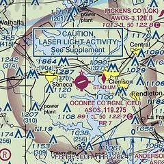
|
| Airport distance calculator |
|---|
|
|
| Sunrise and sunset |
|---|
|
Times for 17-Apr-2024
| | Local
(UTC-4) | | Zulu
(UTC) |
|---|
| Morning civil twilight | | 06:31 | | 10:31 |
| Sunrise | | 06:57 | | 10:57 |
| Sunset | | 20:05 | | 00:05 |
| Evening civil twilight | | 20:31 | | 00:31 |
|
| Current date and time |
|---|
| Zulu (UTC) | 17-Apr-2024 12:47:17 |
|---|
| Local (UTC-4) | 17-Apr-2024 08:47:17 |
|---|
|
| METAR |
|---|
| KCEU | 171154Z AUTO 00000KT 10SM CLR 17/14 A3014 RMK AO2 SLP198 60000 T01720144 10189 20167 53004
|
KLQK
12nm NE | 171235Z AUTO 19003KT 10SM CLR 16/16 A3013 RMK AO2 LTG DSNT NW T01580156
|
KAND
13nm SE | 171156Z AUTO 00000KT 10SM CLR 16/14 A3015 RMK AO2 SLP201 T01610139 10178 20150 53006
|
|
| TAF |
|---|
KAND
13nm SE | 171120Z 1712/1812 VRB03KT P6SM BKN250 FM171500 23007KT P6SM BKN150 FM171700 23013G21KT P6SM BKN120 TEMPO 1723/1803 4SM SHRA SCT050 FM180300 25003KT P6SM BKN250
|
|
| NOTAMs |
|---|
NOTAMs are issued by the DoD/FAA and will open in a separate window not controlled by AirNav.
|
|

