FAA INFORMATION EFFECTIVE 18 APRIL 2024
Location
| FAA Identifier: | CJR |
| Lat/Long: | 38-31-31.7000N 077-51-34.7000W
38-31.528333N 077-51.578333W
38.5254722,-77.8596389
(estimated) |
| Elevation: | 315.5 ft. / 96.2 m (surveyed) |
| Variation: | 10W (2005) |
| From city: | 7 miles NE of CULPEPER, VA |
| Time zone: | UTC -4 (UTC -5 during Standard Time) |
| Zip code: | 22718 |
Airport Operations
| Airport use: | Open to the public |
| Activation date: | 01/1969 |
| Control tower: | no |
| ARTCC: | WASHINGTON CENTER |
| FSS: | LEESBURG FLIGHT SERVICE STATION |
| NOTAMs facility: | CJR (NOTAM-D service available) |
| Attendance: | 0800-1800
HOURS CHANGE MID-OCT, CHECK NOTAMS FOR DETAILS. |
| Wind indicator: | lighted |
| Segmented circle: | yes |
| Lights: | ACTVT REIL RWY 04 & 22; PAPI RWY 04 & 22; MIRL RWY 04/22; TWY LGTS - CTAF. |
| Beacon: | white-green (lighted land airport)
Operates sunset to sunrise. |
Airport Communications
| CTAF/UNICOM: | 123.075 |
| WX AWOS-3: | 119.325 (540-727-0523) |
| POTOMAC APPROACH: | 128.525 |
| POTOMAC DEPARTURE: | 128.525 |
| CLEARANCE DELIVERY: | 121.6 |
| HYPER STAR: | 133.0 |
| TIKEE STAR: | 120.45 |
| TRSTN STAR: | 126.75 |
| WX AWOS-3 at HWY (8 nm NE): | 120.350 (540-788-4078) |
| WX AWOS-3 at OMH (19 nm SW): | 118.075 (540-672-0505) |
| WX AWOS-3PT at HEF (20 nm NE): | PHONE 703-361-6160 |
Nearby radio navigation aids
| VOR radial/distance | | VOR name | | Freq | | Var |
|---|
| CSNr184/6.9 | | CASANOVA VORTAC | | 116.30 | | 06W |
| LDNr147/25.5 | | LINDEN VORTAC | | 114.30 | | 06W |
| BRVr304/26.4 | | BROOKE VORTAC | | 114.50 | | 09W |
| AMLr225/30.7 | | ARMEL VOR/DME | | 113.50 | | 08W |
| GVEr030/33.7 | | GORDONSVILLE VORTAC | | 115.60 | | 06W |
| NDB name | | Hdg/Dist | | Freq | | Var | | ID |
|---|
| NAILR | | 037/4.8 | | 351 | | 10W | | MSQ | -- ... --.- |
| SHANNON | | 319/24.7 | | 237 | | 10W | | EZF | . --.. ..-. |
| CAVERNS | | 119/30.6 | | 245 | | 09W | | LUA | .-.. ..- .- |
| DAVEE | | 266/36.1 | | 223 | | 09W | | DAA | -.. .- .- |
Airport Services
| Fuel available: | 100LL JET-A+ |
| Parking: | tiedowns |
| Airframe service: | MAJOR |
| Powerplant service: | MAJOR |
| Bottled oxygen: | NONE |
| Bulk oxygen: | NONE |
Runway Information
Runway 4/22
| Dimensions: | 5000 x 100 ft. / 1524 x 30 m |
| Surface: | asphalt/grooved, in good condition |
| Weight bearing capacity: | |
| Runway edge lights: | medium intensity |
| RUNWAY 4 | | RUNWAY 22 |
| Latitude: | 38-31.165490N | | 38-31.891145N |
| Longitude: | 077-51.825532W | | 077-51.329330W |
| Elevation: | 315.3 ft. | | 314.5 ft. |
| Traffic pattern: | left | | left |
| Runway heading: | 038 magnetic, 028 true | | 218 magnetic, 208 true |
| Markings: | nonprecision, in good condition | | nonprecision, in good condition |
| Visual slope indicator: | 4-light PAPI on left (3.00 degrees glide path) | | 4-light PAPI on left (3.00 degrees glide path) |
| Runway end identifier lights: | yes | | yes |
| Touchdown point: | yes, no lights | | yes, no lights |
| Instrument approach: | LOCALIZER | | |
| Obstructions: | 30 ft. trees, 1049 ft. from runway, 183 ft. left of centerline, 28:1 slope to clear | | 51 ft. trees, lighted, 1738 ft. from runway, 86 ft. left of centerline, 30:1 slope to clear |
Airport Ownership and Management from official FAA records
| Ownership: | Publicly-owned |
| Owner: | COUNTY OF CULPEPER
302 N MAIN ST
CULPEPER, VA 22701
Phone 540-727-3427 |
| Manager: | TANYA WOODWARD
12517 BEVERLY FORD ROAD
BRANDY STATION, VA 22714
Phone 540-825-8280 |
Airport Operational Statistics
| Aircraft based on the field: | | 152 | | Single engine airplanes: | | 142 | | Multi engine airplanes: | | 7 | | Helicopters: | | 3 |
| |  | |
| Aircraft operations: avg 210/day * | | 55% | local general aviation | | 38% | transient general aviation | | 5% | military | | 1% | air taxi | | * for 12-month period ending 30 September 2017 | |
Additional Remarks
| - | DEER ON AND INVOF ARPT. |
| - | GCO AVBL ON FREQ 121.6 THRU POTOMAC APCH CD. IF UNA, FOR CD CTC POTOMAC APCH AT 866-709-4993. |
| - | TWY AND RAMP MARKINGS GOOD. |
Instrument Procedures
NOTE: All procedures below are presented as PDF files. If you need a reader for these files, you should download the free Adobe Reader.NOT FOR NAVIGATION. Please procure official charts for flight.
FAA instrument procedures published for use from 18 April 2024 at 0901Z to 16 May 2024 at 0900Z.
STARs - Standard Terminal Arrivals |
|---|
| HYPER NINE (RNAV) **NEW** | |
2 pages:
[1] [2] (384KB) |
| HYPER NINE (RNAV), CONT.2 **NEW** | |
download (165KB) |
| TIKEE FOUR (RNAV) | |
download (216KB) |
| TRSTN THREE (RNAV) | |
download (210KB) |
IAPs - Instrument Approach Procedures |
|---|
| RNAV (GPS) RWY 04 | |
download (236KB) |
| RNAV (GPS) RWY 22 | |
download (230KB) |
| LOC RWY 04 | |
download (211KB) |
| VOR-A | |
download (191KB) |
| NDB RWY 04 | |
download (179KB) |
| NOTE: Special Alternate Minimums apply | |
download (143KB) |
| NOTE: Special Take-Off Minimums/Departure Procedures apply | |
download (140KB) |
Other nearby airports with instrument procedures:
KHWY - Warrenton/Fauquier Airport (8 nm NE)
KOMH - Orange County Airport (19 nm SW)
KHEF - Manassas Regional Airport/Harry P. Davis Field (20 nm NE)
KRMN - Stafford Regional Airport (20 nm E)
KEZF - Shannon Airport (25 nm SE)
|
|

Road maps at:
MapQuest
Bing
Google
| Aerial photo |
|---|
WARNING: Photo may not be current or correct
 Photo by Germaine and Matt
Photo taken 12-Jun-2018
looking northeast.
Photo by Germaine and Matt
Photo taken 12-Jun-2018
looking northeast.
Do you have a better or more recent aerial photo of Culpeper Regional Airport that you would like to share? If so, please send us your photo.
|
| Sectional chart |
|---|
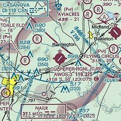
|
CAUTION: Diagram may not be current

| Airport distance calculator |
|---|
|
|
| Sunrise and sunset |
|---|
|
Times for 24-Apr-2024
| | Local
(UTC-4) | | Zulu
(UTC) |
|---|
| Morning civil twilight | | 05:55 | | 09:55 |
| Sunrise | | 06:23 | | 10:23 |
| Sunset | | 19:56 | | 23:56 |
| Evening civil twilight | | 20:24 | | 00:24 |
|
| Current date and time |
|---|
| Zulu (UTC) | 24-Apr-2024 16:33:11 |
|---|
| Local (UTC-4) | 24-Apr-2024 12:33:11 |
|---|
|
| METAR |
|---|
KHWY
8nm NE | 241335Z AUTO 26004KT 10SM CLR 20/07 A2992 RMK AO2 T01950065
|
KCJR
13nm W | 241615Z AUTO 33008KT 10SM SCT080 SCT090 21/04 A2994 RMK AO2 T02120036
|
KOMH
19nm SW | 241615Z AUTO 24004G08KT 10SM BKN070 BKN085 20/05 A2996 RMK AO2
|
KHEF
20nm NE | 241556Z 32011G15KT 10SM SCT065 BKN085 22/07 A2993 RMK AO2 SLP139 T02170067
|
|
| TAF |
|---|
KNYG
27nm E | 2415/2515 25006KT 9999 SCT060 BKN180 QNH2994INS TEMPO 2416/2421 25010G20KT 9999 SCT060 BKN180 FM251300 05006KT 9999 FEW060 SCT180 QNH2993INS T23/2419Z T08/2510Z
|
KIAD
31nm NE | 241502Z 2415/2518 28009G16KT P6SM SCT050 BKN090 FM241900 31014G24KT P6SM FEW090 SCT100 FM250100 33009KT P6SM FEW150 FM250800 01008KT P6SM BKN100
|
|
| NOTAMs |
|---|
NOTAMs are issued by the DoD/FAA and will open in a separate window not controlled by AirNav.
|
|


