FAA INFORMATION EFFECTIVE 18 APRIL 2024
Location
| FAA Identifier: | DDH |
| Lat/Long: | 42-53-28.7890N 073-14-47.0550W
42-53.479817N 073-14.784250W
42.8913303,-73.2464042
(estimated) |
| Elevation: | 826.8 ft. / 252.0 m (surveyed) |
| Variation: | 14W (1980) |
| From city: | 3 miles W of BENNINGTON, VT |
| Time zone: | UTC -4 (UTC -5 during Standard Time) |
| Zip code: | 05201 |
Airport Operations
| Airport use: | Open to the public |
| Activation date: | 12/1937 |
| Control tower: | no |
| ARTCC: | BOSTON CENTER |
| FSS: | BURLINGTON FLIGHT SERVICE STATION |
| NOTAMs facility: | DDH (NOTAM-D service available) |
| Attendance: | SAT-SUN ON CALL, ALL MON-FRI 0800-1600
FOR ARPT ATNDNC CALL 1-802-442-5503 OR 1-802-595-5830 FOR ON-CALL SVCS ONLY. |
| Wind indicator: | lighted |
| Segmented circle: | yes |
| Lights: | ACTVT REIL RWY 13 & 31; PAPI RWY 13 & 31; MIRL RWY 13/31 - CTAF. |
| Beacon: | white-green (lighted land airport)
Operates sunset to sunrise. |
Airport Communications
| CTAF/UNICOM: | 122.8 |
| WX ASOS: | 135.925 (802-442-6059) |
| ALBANY APPROACH: | 132.825 |
| ALBANY DEPARTURE: | 132.825 |
| WX ASOS at AQW (12 nm S): | 134.775 (413-664-6658) |
Nearby radio navigation aids
| VOR radial/distance | | VOR name | | Freq | | Var |
|---|
| CAMr159/7.5 | | CAMBRIDGE VOR/DME | | 115.00 | | 14W |
| ALBr084/26.0 | | ALBANY VORTAC | | 115.30 | | 13W |
| CTRr353/38.3 | | CHESTER VOR/DME | | 115.10 | | 13W |
| NDB name | | Hdg/Dist | | Freq | | Var | | ID |
|---|
| HUNTER | | 100/30.3 | | 356 | | 14W | | HEU | .... . ..- |
Airport Services
| Fuel available: | 100LL JET-A
100LL:100LL SELF-SVC AVBL 24 HRS. |
| Parking: | buoy, hangars and tiedowns |
| Airframe service: | MAJOR |
| Powerplant service: | MAJOR |
| Bottled oxygen: | HIGH |
| Bulk oxygen: | NONE |
Runway Information
Runway 13/31
| Dimensions: | 3704 x 75 ft. / 1129 x 23 m |
| Surface: | asphalt, in fair condition |
| Weight bearing capacity: | |
| Runway edge lights: | medium intensity |
| RUNWAY 13 | | RUNWAY 31 |
| Latitude: | 42-53.624727N | | 42-53.334893N |
| Longitude: | 073-15.149015W | | 073-14.419507W |
| Elevation: | 793.5 ft. | | 826.8 ft. |
| Traffic pattern: | left | | right |
| Runway heading: | 132 magnetic, 118 true | | 312 magnetic, 298 true |
| Markings: | nonprecision, in fair condition | | basic, in fair condition |
| Visual slope indicator: | 4-light PAPI on left (4.00 degrees glide path) | | 4-light PAPI on right (4.00 degrees glide path) |
| Runway end identifier lights: | yes | | yes |
| Touchdown point: | yes, no lights | | yes, no lights |
| Obstructions: | 159 ft. hill, 2781 ft. from runway, 549 ft. right of centerline, 16:1 slope to clear | | 40 ft. gnd, 509 ft. from runway, 178 ft. left of centerline, 7:1 slope to clear
+20 FT GND, 250 FT R OF CNTRLN. |
Airport Ownership and Management from official FAA records
| Ownership: | Publicly-owned |
| Owner: | STATE OF VERMONT
219 N MAIN ST
BARRE, VT 05641
Phone 802-279-2647 |
| Manager: | ROLLIN TEBBETTS
219 N MAIN ST
BARRE, VT 05641
Phone 802-585-5586 |
Airport Operational Statistics
| Aircraft based on the field: | | 26 | | Single engine airplanes: | | 23 | | Multi engine airplanes: | | 3 |
| |  | |
| Aircraft operations: avg 39/day * | | 60% | transient general aviation | | 39% | local general aviation | | <1% | military | | * for 12-month period ending 28 August 2017 | |
Additional Remarks
| - | RWY CONDS MAY NOT BE MNT OR RPRTD WHEN ARPT IS UNATNDD. |
| - | FOR CD CTC ALBANY APCH AT 518-862-2299. |
| - | NOISE ABATEMENT PROCS IN EFCT. AVOID OVER FLYING HOMES SE OF ARPT. NOISE SENSITIVE AREA AER 31. PREFERRED USE RWY IS RWY 13. IF PRACTICAL ACFT DEP RWY 13 USE BEST CLIMB RATE & WHEN ABOVE 400 FT AGL TURN LEFT WITHIN 1 MILE OF DER 13. |
| - | GEESE ON & INVOF ARPT. |
| - | GCO AVBL ON FREQ 121.725 THRU BTV CD & FLT SVCS. OTS INDEFLY. |
| - | RWY 13 THR HAZUS BIRD ACTVTY. |
| - | MTS ALL QUADS. |
| - | TFC PAT OPS PROHIBITED S OF RWY 13 & RWY 31. |
| - | COLD TEMPERATURE AIRPORT. ALTITUDE CORRECTION REQUIRED AT OR BELOW -14C. |
Instrument Procedures
NOTE: All procedures below are presented as PDF files. If you need a reader for these files, you should download the free Adobe Reader.NOT FOR NAVIGATION. Please procure official charts for flight.
FAA instrument procedures published for use from 18 April 2024 at 0901Z to 16 May 2024 at 0900Z.
IAPs - Instrument Approach Procedures |
|---|
| RNAV (GPS) RWY 13 | |
download (334KB) |
| NOTE: Special Take-Off Minimums/Departure Procedures apply | |
download (178KB) |
Other nearby airports with instrument procedures:
KAQW - Harriman-and-West Airport (12 nm S)
KALB - Albany International Airport (26 nm W)
KPSF - Pittsfield Municipal Airport (28 nm S)
5B2 - Saratoga County Airport (29 nm W)
KSCH - Schenectady County Airport (30 nm W)
|
|

Road maps at:
MapQuest
Bing
Google
| Aerial photo |
|---|
WARNING: Photo may not be current or correct
 Photo taken 09-Aug-2009
Do you have a better or more recent aerial photo of William H Morse State Airport that you would like to share? If so, please send us your photo.
|
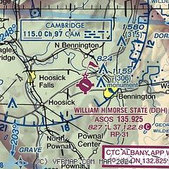
| Sectional chart |
|---|
|
| Airport distance calculator |
|---|
|
|
| Sunrise and sunset |
|---|
|
Times for 23-Apr-2024
| | Local
(UTC-4) | | Zulu
(UTC) |
|---|
| Morning civil twilight | | 05:28 | | 09:28 |
| Sunrise | | 05:58 | | 09:58 |
| Sunset | | 19:44 | | 23:44 |
| Evening civil twilight | | 20:14 | | 00:14 |
|
| Current date and time |
|---|
| Zulu (UTC) | 23-Apr-2024 13:00:35 |
|---|
| Local (UTC-4) | 23-Apr-2024 09:00:35 |
|---|
|
| METAR |
|---|
| KDDH | 231254Z AUTO 36004KT 10SM CLR 09/M02 A3013 RMK AO2 SLP207 T00891017
|
KAQW
12nm S | 231252Z AUTO 11010KT 10SM CLR 08/M04 A3015 RMK AO2 SLP216 T00831039
|
|
| TAF |
|---|
KALB
26nm W | 231120Z 2312/2412 VRB03KT P6SM FEW250 FM231300 17008KT P6SM SCT250 FM231600 18013G24KT P6SM SCT250 FM240000 18010G16KT P6SM FEW120 BKN250 FM240500 17010KT P6SM VCSH BKN090 OVC120 FM240900 17010KT P6SM OVC040 PROB30 2409/2412 4SM -SHRA BR OVC030
|
KPSF
28nm S | 231120Z 2312/2412 VRB02KT P6SM SKC FM231300 16008KT P6SM SCT250 FM231700 20012G22KT P6SM SCT250 FM240000 18009G16KT P6SM FEW120 BKN250 FM240600 17008KT P6SM VCSH BKN080 OVC120 FM240900 18009KT P6SM OVC040 PROB30 2409/2412 4SM -SHRA BR OVC030
|
KGFL
31nm NW | 231120Z 2312/2412 00000KT P6SM SKC FM231300 19008KT P6SM SCT250 FM231700 20012G20KT P6SM FEW120 BKN250 FM240000 20007KT P6SM SCT120 BKN200 FM240400 19006KT P6SM VCSH BKN080 OVC120 FM240900 19006KT P6SM OVC040 PROB30 2409/2412 4SM -SHRA BR OVC030
|
|
| NOTAMs |
|---|
NOTAMs are issued by the DoD/FAA and will open in a separate window not controlled by AirNav.
|
|


