FAA INFORMATION EFFECTIVE 27 NOVEMBER 2025
Location
| FAA Identifier: | EET |
| Lat/Long: | 33-10-40.0000N 086-46-59.6000W
33-10.666667N 086-46.993333W
33.1777778,-86.7832222
(estimated) |
| Elevation: | 585.6 ft. / 178.5 m (surveyed) |
| Variation: | 03W (2010) |
| From city: | 4 miles SE of ALABASTER, AL |
| Time zone: | UTC -6 (UTC -5 during Daylight Saving Time) |
| Zip code: | 35007 |
Airport Operations
| Airport use: | Open to the public |
| Activation date: | 04/1965 |
| Control tower: | no |
| ARTCC: | ATLANTA CENTER |
| FSS: | ANNISTON FLIGHT SERVICE STATION |
| NOTAMs facility: | EET (NOTAM-D service available) |
| Attendance: | 0700-1900 |
| Wind indicator: | lighted |
| Segmented circle: | yes |
| Lights: | ACTVT REIL RWY 16 & 34; PAPI RWY 16 & 34; MIRL RWY 16/34 - CTAF |
| Beacon: | white-green (lighted land airport)
Operates sunset to sunrise. |
Airport Communications
| CTAF/UNICOM: | 122.7 |
| WX ASOS: | 134.325 (205-663-5881) |
| BIRMINGHAM APPROACH: | 123.8 |
| BIRMINGHAM DEPARTURE: | 123.8 |
| WX AWOS-3PT at EKY (11 nm NW): | 118.825 (205-424-3127) |
Nearby radio navigation aids
| VOR radial/distance | | VOR name | | Freq | | Var |
|---|
| OKWr099/23.7 | | BROOKWOOD VORTAC | | 111.00 | | 00E |
| VUZr167/30.1 | | VULCAN VORTAC | | 114.40 | | 02E |
Airport Services
| Fuel available: | 100LL JET-A+
100LL:100LL AVBL 24/7 WITH CC. |
| Parking: | tiedowns |
| Airframe service: | MAJOR |
| Powerplant service: | MAJOR |
| Bottled oxygen: | NONE |
| Bulk oxygen: | NONE |
Runway Information
Runway 16/34
| Dimensions: | 5000 x 75 ft. / 1524 x 23 m |
| Surface: | asphalt, in good condition |
| Weight bearing capacity: | |
| Runway edge lights: | medium intensity |
| RUNWAY 16 | | RUNWAY 34 |
| Latitude: | 33-11.046832N | | 33-10.286653N |
| Longitude: | 086-47.182613W | | 086-46.802997W |
| Elevation: | 572.7 ft. | | 585.6 ft. |
| Traffic pattern: | left | | right |
| Runway heading: | 160 magnetic, 157 true | | 340 magnetic, 337 true |
| Markings: | nonprecision, in good condition | | nonprecision, in good condition |
| Visual slope indicator: | 4-light PAPI on left (3.50 degrees glide path) | | 4-light PAPI on left (4.00 degrees glide path) |
| Runway end identifier lights: | yes | | yes |
| Touchdown point: | yes, no lights | | yes, no lights |
| Obstructions: | 109 ft. tree, 1823 ft. from runway, 510 ft. right of centerline, 14:1 slope to clear | | 64 ft. tree, 1505 ft. from runway, 97 ft. right of centerline, 20:1 slope to clear |
Airport Ownership and Management from official FAA records
| Ownership: | Publicly-owned |
| Owner: | SHELBY COUNTY COMMISSION
P.O. BOX 467
COLUMBIANA, AL 35051
Phone 205-670-6359
CHAD SCROGGINS, COUNTY MANAGER |
| Manager: | TERRY FRANKLIN
265 WEATHER VANE ROAD
CALERA, AL 35040
Phone 205 670 6359 |
Additional Remarks
| - | NOISE ABATEMENT AREA NW OF ARPT. |
| - | BALLOON OPS, HANG GLIDING, PAJA, AND MOTORIZED PARACHUTE OPS PROHIBITED. |
| - | GCO AVBL ON FREQ 121.725 THRU BHM CLEARANCE DELIVERY. |
| - | FOR CD IF UNA VIA GCO CTC BIRMINGHAM APCH AT 205-769-3890. |
| - | 24/7 EMERG CTC # 205-438-5173 |
Instrument Procedures
NOTE: All procedures below are presented as PDF files. If you need a reader for these files, you should download the free Adobe Reader.NOT FOR NAVIGATION. Please procure official charts for flight.
FAA instrument procedures published for use from 27 November 2025 at 0901Z to 25 December 2025 at 0900Z.
IAPs - Instrument Approach Procedures |
|---|
| RNAV (GPS) RWY 16 | |
download (260KB) |
| RNAV (GPS) RWY 34 | |
download (284KB) |
| NOTE: Special Alternate Minimums apply | |
download (153KB) |
| NOTE: Special Take-Off Minimums/Departure Procedures apply | |
download (189KB) |
Other nearby airports with instrument procedures:
KEKY - Bessemer National Airport (11 nm NW)
0A8 - Bibb County Airport (21 nm SW)
02A - Chilton County Airport (21 nm SE)
KBHM - Birmingham-Shuttlesworth International Airport (23 nm N)
KSCD - Merkel Field Sylacauga Municipal Airport (24 nm E)
|
|

Road maps at:
MapQuest
Bing
Google
| Aerial photo |
|---|
WARNING: Photo may not be current or correct

Do you have a better or more recent aerial photo of Shelby County Airport that you would like to share? If so, please send us your photo.
|
| Sectional chart |
|---|
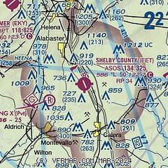
|
| Airport distance calculator |
|---|
|
|
| Sunrise and sunset |
|---|
|
Times for 09-Dec-2025
| | Local
(UTC-6) | | Zulu
(UTC) |
|---|
| Morning civil twilight | | 06:13 | | 12:13 |
| Sunrise | | 06:40 | | 12:40 |
| Sunset | | 16:39 | | 22:39 |
| Evening civil twilight | | 17:06 | | 23:06 |
|
| Current date and time |
|---|
| Zulu (UTC) | 09-Dec-2025 23:07:49 |
|---|
| Local (UTC-6) | 09-Dec-2025 17:07:49 |
|---|
|
| METAR |
|---|
| KEET | 092253Z AUTO 00000KT 10SM CLR 08/02 A3009 RMK AO2 SLP193 T00780017
|
KEKY
11nm NW | 092256Z AUTO 22003KT CLR 07/02 A3010 RMK AO2 SLP176 T00720017 PWINO RVRNO $
|
|
| TAF |
|---|
| KEET | 091731Z 0918/1018 19005KT P6SM SCT250 FM101500 22012G20KT P6SM SCT250
|
|
| NOTAMs |
|---|
NOTAMs are issued by the DoD/FAA and will open in a separate window not controlled by AirNav.
|
|

