FAA INFORMATION EFFECTIVE 18 APRIL 2024
Location
| FAA Identifier: | F06 |
| Lat/Long: | 34-50-41.5163N 100-11-42.6877W
34-50.691938N 100-11.711462W
34.8448656,-100.1951910
(estimated) |
| Elevation: | 2009 ft. / 612.3 m (surveyed) |
| Variation: | 08E (1985) |
| From city: | 1 mile SE of WELLINGTON, TX |
| Time zone: | UTC -5 (UTC -6 during Standard Time) |
| Zip code: | 79095 |
Airport Operations
| Airport use: | Open to the public |
| Activation date: | 09/1947 |
| Control tower: | no |
| ARTCC: | FORT WORTH CENTER |
| FSS: | FORT WORTH FLIGHT SERVICE STATION |
| NOTAMs facility: | FTW (NOTAM-D service available) |
| Attendance: | UNATNDD |
| Wind indicator: | lighted |
| Segmented circle: | yes |
| Lights: | MIRLS RY 12/30 PRESET TO LOW TO INCR INST AND ACTVT - CTAF. |
Airport Communications
Nearby radio navigation aids
| VOR radial/distance | | VOR name | | Freq | | Var |
|---|
| CDSr359/28.9 | | CHILDRESS VORTAC | | 117.00 | | 10E |
Airport Services
| Fuel available: | 100LL |
| Parking: | tiedowns |
| Bottled oxygen: | NONE |
| Bulk oxygen: | NONE |
Runway Information
Runway 12/30
| Dimensions: | 4035 x 60 ft. / 1230 x 18 m |
| Surface: | asphalt, in good condition |
| Weight bearing capacity: | |
| Runway edge lights: | medium intensity |
| Runway edge markings: | MARKINGS FADED, BARELY VSBL. |
| RUNWAY 12 | | RUNWAY 30 |
| Latitude: | 34-50.909500N | | 34-50.436500N |
| Longitude: | 100-11.891167W | | 100-11.324000W |
| Elevation: | 2009.0 ft. | | 1998.0 ft. |
| Traffic pattern: | left | | left |
| Displaced threshold: | 525 ft. | | no |
| Markings: | basic, in poor condition | | basic, in poor condition |
| Obstructions: | 18 ft. road, 200 ft. from runway, 87 ft. left of centerline
4 FT FENCE 150 FT DSTC 90 FT L. | | 10 ft. road, 440 ft. from runway, 145 ft. right of centerline, 24:1 slope to clear |
Runway 17/35
| Dimensions: | 1819 x 60 ft. / 554 x 18 m |
| Surface: | asphalt, in excellent condition |
| Weight bearing capacity: | |
| RUNWAY 17 | | RUNWAY 35 |
| Latitude: | 34-50.891833N | | 34-50.591833N |
| Longitude: | 100-11.896000W | | 100-11.896000W |
| Elevation: | 2009.0 ft. | | 2000.8 ft. |
| Traffic pattern: | left | | left |
| Displaced threshold: | 219 ft. | | no |
| Markings: | basic, in good condition | | basic, in good condition |
| Obstructions: | 20 ft. road, 322 ft. from runway, 6:1 slope to clear
APCH SLOPE 27:1 TO DSPLCD THR OVR 20 FT RD, 540 FT DSTC, 0B. | | none |
Runway 4/22
| Dimensions: | 1010 x 135 ft. / 308 x 41 m |
| Surface: | turf, in fair condition |
| Runway edge markings: | RWY 04/22 MKD WITH 3 FT BARREL HALVES PAINTED BLACK & WHITE. |
| RUNWAY 4 | | RUNWAY 22 |
| Latitude: | 34-50.623667N | | 34-50.739333N |
| Longitude: | 100-11.870167W | | 100-11.725000W |
| Elevation: | 2001.0 ft. | | 2005.0 ft. |
| Traffic pattern: | left | | left |
| Obstructions: | none | | 60 ft. pole, 686 ft. from runway, 65 ft. right of centerline, 11:1 slope to clear |
Airport Ownership and Management from official FAA records
| Ownership: | Publicly-owned |
| Owner: | CITY OF WELLINGTON
PO BOX 949
WELLINGTON, TX 79095
Phone 806-447-2544 |
| Manager: | JON SESSIONS
PO BOX 949
WELLINGTON, TX 79095
Phone 806-447-2544
CITY MANAGER. |
Airport Operational Statistics
| Aircraft based on the field: | | 3 | | Single engine airplanes: | | 3 |
| |  | |
| Aircraft operations: avg 59/week * | | 65% | local general aviation | | 33% | transient general aviation | | 2% | military | | * for 12-month period ending 18 November 2023 | |
Additional Remarks
| - | EXTENSIVE AG OPNS DURING SPRING/SUMMER. |
| - | FOR CD CTC FORT WORTH ARTCC AT 817-858-7584. |
Instrument Procedures
There are no published instrument procedures at F06.
Some nearby airports with instrument procedures:
O35 - Hollis Municipal Airport (16 nm SE)
KCDS - Childress Municipal Airport (25 nm S)
2K4 - Scott Field Airport (33 nm E)
T59 - Wheeler Municipal Airport (36 nm N)
KAXS - Altus/Quartz Mountain Regional Airport (43 nm E)
|
|

Road maps at:
MapQuest
Bing
Google
| Aerial photo |
|---|

|
| Sectional chart |
|---|
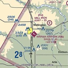
|
| Airport distance calculator |
|---|
|
|
| Sunrise and sunset |
|---|
|
Times for 19-Apr-2024
| | Local
(UTC-5) | | Zulu
(UTC) |
|---|
| Morning civil twilight | | 06:37 | | 11:37 |
| Sunrise | | 07:04 | | 12:04 |
| Sunset | | 20:16 | | 01:16 |
| Evening civil twilight | | 20:42 | | 01:42 |
|
| Current date and time |
|---|
| Zulu (UTC) | 19-Apr-2024 11:42:11 |
|---|
| Local (UTC-5) | 19-Apr-2024 06:42:11 |
|---|
|
| TAF |
|---|
KCDS
25nm S | 190523Z 1906/2006 05011KT P6SM SCT250 FM191500 05011KT P6SM BKN250
|
|
| NOTAMs |
|---|
NOTAMs are issued by the DoD/FAA and will open in a separate window not controlled by AirNav.
|
|


