FAA INFORMATION EFFECTIVE 18 APRIL 2024
Location
| FAA Identifier: | FVX |
| Lat/Long: | 37-21-27.1000N 078-26-16.1000W
37-21.451667N 078-26.268333W
37.3575278,-78.4378056
(estimated) |
| Elevation: | 415.7 ft. / 126.7 m (surveyed) |
| Variation: | 09W (2000) |
| From city: | 4 miles NW of FARMVILLE, VA |
| Time zone: | UTC -4 (UTC -5 during Standard Time) |
| Zip code: | 23901 |
Airport Operations
| Airport use: | Open to the public |
| Control tower: | no |
| ARTCC: | WASHINGTON CENTER |
| FSS: | LEESBURG FLIGHT SERVICE STATION |
| NOTAMs facility: | FVX (NOTAM-D service available) |
| Attendance: | 0730-1700 |
| Wind indicator: | lighted |
| Segmented circle: | no |
| Lights: | REIL RWY 3 & 21; MIRL RWY 03/21; PRESET LOW INTST, TO INCR INTST ACTVT - CTAF. |
| Beacon: | white-green (lighted land airport)
Operates sunset to sunrise. |
Airport Communications
| CTAF/UNICOM: | 122.8 |
| WX AWOS-3: | 132.725 (434-392-9718) |
| ROANOKE APPROACH: | 135.0 |
| ROANOKE DEPARTURE: | 135.0 |
| IC: | 135.0 |
| WX AWOS-3 at W81 (19 nm SE): | 119.050 |
- APCH/DEP SVC PRVDD BY ATCT ROANOKE ON FREQS 135.0/254.32.
Nearby radio navigation aids
| VOR radial/distance | | VOR name | | Freq | | Var |
|---|
| FAKr257/30.8 | | FLAT ROCK VORTAC | | 113.30 | | 06W |
| LYHr086/38.6 | | LYNCHBURG VOR/DME | | 109.20 | | 05W |
| NDB name | | Hdg/Dist | | Freq | | Var | | ID |
|---|
| BLACKSTONE | | 315/23.3 | | 326 | | 09W | | BKT | -... -.- - |
Airport Services
| Fuel available: | 100LL JET-A |
| Parking: | hangars and tiedowns |
| Airframe service: | MINOR |
| Powerplant service: | MINOR |
| Bottled oxygen: | NONE |
| Bulk oxygen: | NONE |
Runway Information
Runway 3/21
| Dimensions: | 4400 x 75 ft. / 1341 x 23 m |
| Surface: | asphalt/grooved, in excellent condition |
| Weight bearing capacity: | |
| Runway edge lights: | medium intensity |
| RUNWAY 3 | | RUNWAY 21 |
| Latitude: | 37-21.111523N | | 37-21.791737N |
| Longitude: | 078-26.424647W | | 078-26.110347W |
| Elevation: | 409.7 ft. | | 415.7 ft. |
| Traffic pattern: | left | | left |
| Runway heading: | 029 magnetic, 020 true | | 209 magnetic, 200 true |
| Markings: | nonprecision, in good condition | | nonprecision, in good condition |
| Visual slope indicator: | 2-light PAPI on left (3.00 degrees glide path) | | 2-light PAPI on left (3.00 degrees glide path) |
| Runway end identifier lights: | yes | | yes |
| Touchdown point: | yes, no lights | | yes, no lights |
| Obstructions: | 10 ft. hill, 333 ft. from runway, 128 ft. left of centerline, 13:1 slope to clear
TERRAIN 333 FT FROM THR, 128 RIGHT OF CTLN AND 10 FT ABOVE RWY ELEVATION. | | 35 ft. tree, 652 ft. from runway, 291 ft. right of centerline, 12:1 slope to clear |
Airport Ownership and Management from official FAA records
| Ownership: | Publicly-owned |
| Owner: | TOWN OF FARMVILLE
P.O. DRAWER 368
FARMVILLE, VA 23901
Phone 434-392-5686 |
| Manager: | SCOTT DAVIS
P.O. DRAWER 368
FARMVILLE, VA 23901-9116
Phone 434-392-5686 |
Airport Operational Statistics
| Aircraft based on the field: | | 12 | | Single engine airplanes: | | 10 | | Multi engine airplanes: | | 1 | | Jet airplanes: | | 1 |
| |  | |
| Aircraft operations: avg 39/day * | | 55% | local general aviation | | 41% | transient general aviation | | 3% | military | | * for 12-month period ending 31 December 2020 | |
Additional Remarks
| - | DEER ON AND INVOF ARPT. |
| - | LGTD TWR 320 AGL 5.8 MI SW. |
| - | POSS UNMANNED AERIAL VEHICLE OPER 5 NM FROM FARMVILLE ARPT 3000 FT AGL & BLW. |
| - | ROA TWR SVCS AVBL AT 540-563-1307. |
| - | FOR CD CTC ROANOKE APCH AT 540-563-1307. |
Instrument Procedures
NOTE: All procedures below are presented as PDF files. If you need a reader for these files, you should download the free Adobe Reader.NOT FOR NAVIGATION. Please procure official charts for flight.
FAA instrument procedures published for use from 18 April 2024 at 0901Z to 16 May 2024 at 0900Z.
IAPs - Instrument Approach Procedures |
|---|
| RNAV (GPS) RWY 03 | |
download (252KB) |
| RNAV (GPS) RWY 21 | |
download (247KB) |
| NOTE: Special Alternate Minimums apply | |
download (35KB) |
| NOTE: Special Take-Off Minimums/Departure Procedures apply | |
download (215KB) |
Other nearby airports with instrument procedures:
W81 - Crewe Municipal Airport (19 nm SE)
W31 - Lunenburg County Airport (27 nm SE)
KBKT - Allen C Perkinson Airport/Blackstone Army Airfield (29 nm SE)
0V4 - Brookneal/Campbell County Airport (31 nm SW)
W24 - Falwell Airport (33 nm W)
|
|

Road maps at:
MapQuest
Bing
Google
| Aerial photo |
|---|
WARNING: Photo may not be current or correct
 Photo by Gregory York
Photo taken 15-Mar-2012
looking Southeast at 8,000 MSL.
Photo by Gregory York
Photo taken 15-Mar-2012
looking Southeast at 8,000 MSL.
Do you have a better or more recent aerial photo of Farmville Regional Airport that you would like to share? If so, please send us your photo.
|
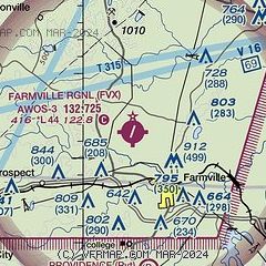
| Sectional chart |
|---|
|
| Airport distance calculator |
|---|
|
|
| Sunrise and sunset |
|---|
|
Times for 19-Apr-2024
| | Local
(UTC-4) | | Zulu
(UTC) |
|---|
| Morning civil twilight | | 06:06 | | 10:06 |
| Sunrise | | 06:33 | | 10:33 |
| Sunset | | 19:52 | | 23:52 |
| Evening civil twilight | | 20:19 | | 00:19 |
|
| Current date and time |
|---|
| Zulu (UTC) | 19-Apr-2024 11:16:33 |
|---|
| Local (UTC-4) | 19-Apr-2024 07:16:33 |
|---|
|
| METAR |
|---|
| KFVX | 191055Z AUTO 08004KT 10SM OVC006 13/12 A3007 RMK AO2 T01300120
|
KW81
19nm SE | 191055Z AUTO 00000KT 7SM OVC004 12/10 A3008 RMK AO1 T01150100
|
|
| TAF |
|---|
KLYH
36nm W | 190537Z 1906/2006 05006KT P6SM SCT250 FM191100 08005KT P6SM SCT015 TEMPO 1911/1915 OVC015 FM191500 08005KT P6SM OVC020 FM191900 20007KT P6SM BKN040 FM200300 VRB04KT P6SM SCT025
|
|
| NOTAMs |
|---|
NOTAMs are issued by the DoD/FAA and will open in a separate window not controlled by AirNav.
|
|

