FAA INFORMATION EFFECTIVE 18 APRIL 2024
Location
| FAA Identifier: | HSB |
| Lat/Long: | 37-48-40.5220N 088-33-00.9347W
37-48.675367N 088-33.015578W
37.8112561,-88.5502596
(estimated) |
| Elevation: | 398 ft. / 121.3 m (surveyed) |
| Variation: | 00E (1990) |
| From city: | 4 miles N of HARRISBURG, IL |
| Time zone: | UTC -5 (UTC -6 during Standard Time) |
| Zip code: | 62977 |
Airport Operations
| Airport use: | Open to the public |
| Activation date: | 09/1950 |
| Control tower: | no |
| ARTCC: | KANSAS CITY CENTER |
| FSS: | SAINT LOUIS FLIGHT SERVICE STATION |
| NOTAMs facility: | HSB (NOTAM-D service available) |
| Attendance: | 0800-1700 |
| Wind indicator: | lighted |
| Segmented circle: | yes |
| Lights: | REIL RWY 06 & 24; MIRL RWY 06/24 PRESET ON LOW INTST; TO INCR INTST & ACTVT MIRL RWY 14/32 - CTAF. |
| Beacon: | white-green (lighted land airport)
Operates sunset to sunrise. |
Airport Communications
| CTAF/UNICOM: | 122.8 |
| WX AWOS-3PT: | 135.925 (618-253-3010) |
- APCH/DEP SVC PRVDD BY KANSAS CITY ARTCC ON FREQS 127.475/346.275 (MARION RCAG).
Nearby radio navigation aids
| VOR radial/distance | | VOR name | | Freq | | Var |
|---|
| PXVr256/38.0 | | POCKET CITY VORTAC | | 113.30 | | 03E |
| NDB name | | Hdg/Dist | | Freq | | Var | | ID |
|---|
| WAYNE COUNTY | | 192/34.8 | | 257 | | 01W | | FWC | ..-. .-- -.-. |
Airport Services
| Fuel available: | 100LL JET-A |
| Parking: | hangars and tiedowns |
| Airframe service: | MINOR |
| Powerplant service: | MINOR |
Runway Information
Runway 6/24
| Dimensions: | 5013 x 75 ft. / 1528 x 23 m |
| Surface: | asphalt, in fair condition |
| Weight bearing capacity: | |
| Runway edge lights: | medium intensity |
| RUNWAY 6 | | RUNWAY 24 |
| Latitude: | 37-48.537752N | | 37-48.911648N |
| Longitude: | 088-33.568195W | | 088-32.639690W |
| Elevation: | 386.7 ft. | | 396.2 ft. |
| Traffic pattern: | left | | left |
| Runway heading: | 063 | | 243 |
| Markings: | nonprecision, in good condition | | nonprecision, in good condition |
| Visual slope indicator: | 4-light PAPI on left (3.00 degrees glide path) | | 4-light PAPI on left (3.00 degrees glide path) |
| Runway end identifier lights: | yes | | yes |
| Touchdown point: | yes, no lights | | yes, no lights |
| Obstructions: | none | | 31 ft. tree, 721 ft. from runway, 179 ft. left of centerline, 16:1 slope to clear |
Runway 14/32
| Dimensions: | 2764 x 75 ft. / 842 x 23 m
HAS A 900 FT STWY NW END. |
| Surface: | asphalt, in good condition |
| Weight bearing capacity: | |
| Runway edge lights: | medium intensity |
| RUNWAY 14 | | RUNWAY 32 |
| Latitude: | 37-48.762583N | | 37-48.409200N |
| Longitude: | 088-33.036317W | | 088-32.674317W |
| Elevation: | 387.4 ft. | | 381.9 ft. |
| Traffic pattern: | left | | left |
| Runway heading: | 141 | | 321 |
| Markings: | basic, in fair condition | | basic, in fair condition |
| Runway end identifier lights: | no | | no |
| Touchdown point: | yes, no lights | | yes, no lights |
Airport Ownership and Management from official FAA records
| Ownership: | Publicly-owned |
| Owner: | HARRISBURG RALEIGH AIRPORT
P.O. BOX 33
HARRISBURG, IL 62946
Phone 618-253-7806 |
| Manager: | DALE SHELTON
P.O. BOX 33
HARRISBURG, IL 62946
Phone 618-253-7806
EMAIL ADDRESS: DSHELTON1018@GMAIL.COM (ALL LOWER CASE) |
Airport Operational Statistics
| Aircraft based on the field: | | 15 | | Single engine airplanes: | | 13 | | Multi engine airplanes: | | 1 | | Helicopters: | | 1 |
| |  | |
| Aircraft operations: avg 49/day * | | 58% | local general aviation | | 32% | transient general aviation | | 8% | air taxi | | 2% | military | | * for 12-month period ending 31 March 2018 | |
Additional Remarks
| - | ULTRALIGHT ACTIVITY ON & INVOF ARPT. |
| - | FOR SVCS OR JET A FUEL AFT HRS CALL AMGR AT 618-499-5058 (CELL). |
| - | 24 HR SELF SERVE 100LL FUEL AVBL WITH CREDIT CARD. |
| - | FOR CD CTC KANSAS CITY ARTCC AT 913-254-8508. |
Instrument Procedures
NOTE: All procedures below are presented as PDF files. If you need a reader for these files, you should download the free Adobe Reader.NOT FOR NAVIGATION. Please procure official charts for flight.
FAA instrument procedures published for use from 18 April 2024 at 0901Z to 16 May 2024 at 0900Z.
IAPs - Instrument Approach Procedures |
|---|
| RNAV (GPS) RWY 06 | |
download (278KB) |
| RNAV (GPS) RWY 24 | |
download (241KB) |
| NOTE: Special Alternate Minimums apply | |
download (141KB) |
| NOTE: Special Take-Off Minimums/Departure Procedures apply | |
download (201KB) |
Other nearby airports with instrument procedures:
H96 - Benton Municipal Airport (22 nm NW)
KMWA - Veterans Airport of Southern Illinois (22 nm W)
KCUL - Carmi Municipal Airport (26 nm NE)
KTWT - Sturgis Municipal Airport (33 nm SE)
KMDH - Southern Illinois Airport (33 nm W)
|
|

Road maps at:
MapQuest
Bing
Google
| Aerial photo |
|---|
WARNING: Photo may not be current or correct

Do you have a better or more recent aerial photo of Harrisburg-Raleigh Airport that you would like to share? If so, please send us your photo.
|
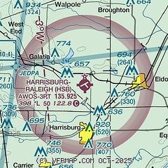
| Sectional chart |
|---|
|
| Airport distance calculator |
|---|
|
|
| Sunrise and sunset |
|---|
|
Times for 23-Apr-2024
| | Local
(UTC-5) | | Zulu
(UTC) |
|---|
| Morning civil twilight | | 05:40 | | 10:40 |
| Sunrise | | 06:08 | | 11:08 |
| Sunset | | 19:37 | | 00:37 |
| Evening civil twilight | | 20:05 | | 01:05 |
|
| Current date and time |
|---|
| Zulu (UTC) | 23-Apr-2024 09:55:48 |
|---|
| Local (UTC-5) | 23-Apr-2024 04:55:48 |
|---|
|
| TAF |
|---|
KMVN
34nm NW | 230520Z 2306/2406 20007KT P6SM BKN250 FM231400 21013G23KT P6SM BKN250 FM232100 21005KT 4SM SHRA BKN025 PROB30 2322/2403 3SM TSRA BKN025CB
|
|
| NOTAMs |
|---|
NOTAMs are issued by the DoD/FAA and will open in a separate window not controlled by AirNav.
|
|

