FAA INFORMATION EFFECTIVE 18 APRIL 2024
Location
| FAA Identifier: | HUL |
| Lat/Long: | 46-07-28.5850N 067-47-32.4970W
46-07.476417N 067-47.541617W
46.1246069,-67.7923603
(estimated) |
| Elevation: | 489.4 ft. / 149.2 m (surveyed) |
| Variation: | 18W (2010) |
| From city: | 2 miles E of HOULTON, ME |
| Time zone: | UTC -4 (UTC -5 during Standard Time) |
| Zip code: | 04730 |
Airport Operations
| Airport use: | Open to the public |
| Activation date: | 04/1940 |
| Control tower: | no |
| ARTCC: | BOSTON CENTER |
| FSS: | BANGOR FLIGHT SERVICE STATION |
| NOTAMs facility: | HUL (NOTAM-D service available) |
| Attendance: | MON-FRI 0700-1700, ALL SAT-SUN UNATNDD |
| Wind indicator: | lighted |
| Segmented circle: | yes |
| Lights: | DUSK-DAWN. ACTVT REIL RWY 05 & 23; PAPI RWY 05; MIRL RWY 05/23 - CTAF. |
| Beacon: | white-green (lighted land airport)
Operates sunset to sunrise. |
| International operations: | international airport of entry |
Airport Communications
| CTAF/UNICOM: | 122.8 |
| WX ASOS: | 132.025 (207-532-1584) |
- APCH/DEP SVC PRVDD BY BOSTON ARTCC ON FREQ 120.25/346.4 (HOULTON RCAG).
Airport Services
| Fuel available: | 100LL JET-A JET-A+
100LL:FOR JET A FUEL AFT HRS CALL 207-538-7997. 100 LL IS AVBL 24 HRS WITH MAJOR CREDIT CARD. |
| Parking: | hangars and tiedowns |
| Airframe service: | MAJOR |
| Powerplant service: | MAJOR |
| Bottled oxygen: | NONE |
| Bulk oxygen: | NONE |
Runway Information
Runway 5/23
| Dimensions: | 5015 x 100 ft. / 1529 x 30 m |
| Surface: | asphalt/grooved, in good condition |
| Weight bearing capacity: | | Single wheel: | 30.0 | | Double wheel: | 57.0 |
|
| Runway edge lights: | medium intensity |
| RUNWAY 5 | | RUNWAY 23 |
| Latitude: | 46-07.030997N | | 46-07.736583N |
| Longitude: | 067-47.830938W | | 067-47.215925W |
| Elevation: | 483.0 ft. | | 489.3 ft. |
| Traffic pattern: | left | | left |
| Runway heading: | 049 magnetic, 031 true | | 229 magnetic, 211 true |
| Markings: | nonprecision, in good condition | | nonprecision, in good condition |
| Visual slope indicator: | 4-light PAPI on left (3.00 degrees glide path) | | |
| Runway end identifier lights: | yes | | yes |
| Touchdown point: | yes, no lights | | yes, no lights |
| Obstructions: | none | | 14 ft. tree, 430 ft. from runway, 107 ft. left of centerline, 16:1 slope to clear
BRUSH AT 66 FT FM RWY END, 178 FT R. |
Runway 1/19
| Dimensions: | 2700 x 60 ft. / 823 x 18 m |
| Surface: | asphalt, in good condition |
| Runway edge markings: | FADED. |
| RUNWAY 1 | | RUNWAY 19 |
| Latitude: | 46-07.428598N | | 46-07.868353N |
| Longitude: | 067-47.530468W | | 067-47.620250W |
| Elevation: | 473.8 ft. | | 477.8 ft. |
| Traffic pattern: | left | | left |
| Runway heading: | 010 magnetic, 352 true | | 190 magnetic, 172 true |
| Markings: | basic, in poor condition | | basic, in poor condition |
| Touchdown point: | yes, no lights | | yes, no lights |
| Obstructions: | none | | 21 ft. pole, 602 ft. from runway, 112 ft. left of centerline, 19:1 slope to clear |
Airport Ownership and Management from official FAA records
| Ownership: | Publicly-owned |
| Owner: | TOWN OF HOULTON
21 WATER STREET
HOULTON, ME 04730
Phone 207-532-7111 |
| Manager: | CHRISTOPHER STEWART
21 WATER ST.
HOULTON, ME 04730
Phone (207) 532-1325
ALTN: 207-538-7997. |
Airport Operational Statistics
| Aircraft based on the field: | | 15 | | Single engine airplanes: | | 12 | | Multi engine airplanes: | | 3 |
| |  | |
| Aircraft operations: avg 35/day * | | 55% | local general aviation | | 39% | transient general aviation | | 6% | military | | * for 12-month period ending 11 August 2021 | |
Additional Remarks
| - | USDA RECATERING FAC AVBL. |
| - | DEER ON & INVOF ARPT. |
| - | FOR AFT HRS ACES TO TRML BLDG USE FREQ 122.8. |
| - | FOR CD IF UNA TO CTC ON FSS FREQ, CTC BOSTON ARTCC AT 603-879-6859 . |
Instrument Procedures
NOTE: All procedures below are presented as PDF files. If you need a reader for these files, you should download the free Adobe Reader.NOT FOR NAVIGATION. Please procure official charts for flight.
FAA instrument procedures published for use from 18 April 2024 at 0901Z to 16 May 2024 at 0900Z.
IAPs - Instrument Approach Procedures |
|---|
| RNAV (GPS) RWY 05 **CHANGED** | |
download (238KB) |
| RNAV (GPS) RWY 23 **NEW** | |
download (227KB) |
| NOTE: Special Alternate Minimums apply **CHANGED** | |
download (153KB) |
| NOTE: Special Take-Off Minimums/Departure Procedures apply | |
download (428KB) |
Other nearby airports with instrument procedures:
KPQI - Presque Isle International Airport (35 nm N)
KCAR - Caribou Municipal Airport (46 nm N)
KMLT - Millinocket Municipal Airport (47 nm SW)
KLRG - Lincoln Regional Airport (55 nm SW)
KPNN - Princeton Municipal Airport (56 nm S)
|
|

Road maps at:
MapQuest
Bing
Google
| Aerial photo |
|---|
WARNING: Photo may not be current or correct

Do you have a better or more recent aerial photo of Houlton International Airport that you would like to share? If so, please send us your photo.
|
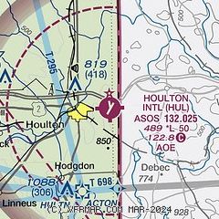
| Sectional chart |
|---|
|
 Download PDF
of official airport diagram from the FAA
| Airport distance calculator |
|---|
|
|
| Sunrise and sunset |
|---|
|
Times for 25-Apr-2024
| | Local
(UTC-4) | | Zulu
(UTC) |
|---|
| Morning civil twilight | | 04:54 | | 08:54 |
| Sunrise | | 05:27 | | 09:27 |
| Sunset | | 19:31 | | 23:31 |
| Evening civil twilight | | 20:04 | | 00:04 |
|
| Current date and time |
|---|
| Zulu (UTC) | 25-Apr-2024 07:38:12 |
|---|
| Local (UTC-4) | 25-Apr-2024 03:38:12 |
|---|
|
| METAR |
|---|
| KHUL | 250653Z AUTO 29010G22KT 10SM CLR M06/M13 A3004 RMK AO2 SLP181 T10561128
|
|
| TAF |
|---|
| KHUL | 250523Z 2506/2606 31015G25KT P6SM SCT050 FM252200 30008KT P6SM SKC
|
|
| NOTAMs |
|---|
NOTAMs are issued by the DoD/FAA and will open in a separate window not controlled by AirNav.
|
|

