FAA INFORMATION EFFECTIVE 18 APRIL 2024
Location
| FAA Identifier: | I64 |
| Lat/Long: | 41-17-36.5700N 082-22-20.5000W
41-17.609500N 082-22.341667W
41.2934917,-82.3723611
(estimated) |
| Elevation: | 848 ft. / 258.5 m (surveyed) |
| Variation: | 06W (1985) |
| From city: | 3 miles NE of WAKEMAN, OH |
| Time zone: | UTC -4 (UTC -5 during Standard Time) |
| Zip code: | 44889 |
Airport Operations
| Airport use: | Open to the public |
| Control tower: | no |
| ARTCC: | CLEVELAND CENTER |
| FSS: | CLEVELAND FLIGHT SERVICE STATION |
| NOTAMs facility: | CLE (NOTAM-D service available) |
| Attendance: | MON-SAT 0800-DUSK, ALL SUN 0900-1700 |
| Wind indicator: | yes |
| Segmented circle: | no |
| Lights: | ACTVT NSTD LIRL RWY 04/22 - CTAF. |
Airport Communications
| CTAF/UNICOM: | 122.8 |
| WX ASOS at LPR (9 nm E): | 118.925 (440-323-7088) |
Nearby radio navigation aids
| VOR radial/distance | | VOR name | | Freq | | Var |
|---|
| DJBr253/10.2 | | DRYER VOR/DME | | 113.60 | | 05W |
| MFDr024/27.3 | | MANSFIELD VORTAC | | 108.80 | | 03W |
| NDB name | | Hdg/Dist | | Freq | | Var | | ID |
|---|
| PORT CLINTON | | 128/26.1 | | 423 | | 07W | | PCW | .--. -.-. .-- |
| TIFFIN | | 078/39.9 | | 269 | | 05W | | TII | - .. .. |
Airport Services
| Fuel available: | 100LL |
| Parking: | hangars and tiedowns |
| Airframe service: | MAJOR |
| Powerplant service: | MAJOR |
| Bottled oxygen: | NONE |
| Bulk oxygen: | NONE |
Runway Information
Runway 4/22
| Dimensions: | 3800 x 55 ft. / 1158 x 17 m |
| Surface: | asphalt/gravel, in good condition
FOD ON RWY EDGE.
50 FT PAVED & 5 FT GRVL SHOULDERS; POSS GRVL ON ASPH. |
| Runway edge lights: | non-standard
LIRL LCTD 28 FT FM RWY EDGE; UNLGTD 134 FT FM AER 22; NON-FRANGIBLE STAKES 12-23 INS AGL. |
| Runway edge markings: | RWY NR DSPLCD FM THR. |
| RUNWAY 4 | | RUNWAY 22 |
| Latitude: | 41-17.335435N | | 41-17.883570N |
| Longitude: | 082-22.541765W | | 082-22.141570W |
| Elevation: | 848.0 ft. | | 848.0 ft. |
| Traffic pattern: | left | | left |
| Runway heading: | 035 magnetic, 029 true | | 215 magnetic, 209 true |
| Markings: | NSTD, in good condition | | NSTD, in good condition |
| Runway end identifier lights: | no | | no |
| Obstructions: | 90 ft. trees, 700 ft. from runway, 130 ft. right of centerline, 5:1 slope to clear
8 FT CROPS, 100 FT FM THR, 70 FT L & R OF CNTRLN, CLNC SLOPE 0:1. | | 100 ft. trees, 1995 ft. from runway, 22 ft. right of centerline, 17:1 slope to clear
8 FT CROPS, 30 FT FM THR, 125 FT L & R OF CNTRLN, CLNC SLOPE 0:1. |
Airport Ownership and Management from official FAA records
| Ownership: | Privately-owned |
| Owner: | COURTNEY ORTNER
10715 STATE ROUTE 60
WAKEMAN, OH 44889-9059
Phone 440-839-1935 |
| Manager: | COURTNEY ORTNER
9620 STATE ROUTE 60
WAKEMAN, OH 44889-9236
Phone 440-965-7787
OTR 440-960-6911. |
Airport Operational Statistics
| Aircraft based on the field: | | 33 | | Single engine airplanes: | | 24 | | Multi engine airplanes: | | 1 | | Gliders airplanes: | | 8 |
| |  | |
| Aircraft operations: avg 28/day * | | 99% | local general aviation | | 1% | transient general aviation | | * for 12-month period ending 20 July 2020 | |
Additional Remarks
| - | DEER, BIRDS, & OTR WILDLIFE ON & INVOF ARPT. |
| - | GLD ACT ON & INVOF ARPT; TKOF/LDG OPDT POSS. |
| - | FOR CD CTC CLEVELAND APCH AT 216-352-2323. |
Instrument Procedures
There are no published instrument procedures at I64.
Some nearby airports with instrument procedures:
5A1 - Norwalk-Huron County Airport (9 nm W)
KLPR - Lorain County Regional Airport (9 nm E)
1G1 - Elyria Airport (12 nm E)
8G1 - Willard Airport (22 nm SW)
3G4 - Ashland County Airport (24 nm S)
|
|

Road maps at:
MapQuest
Bing
Google
| Aerial photo |
|---|
WARNING: Photo may not be current or correct
 looking northeast
Do you have a better or more recent aerial photo of Ortner Airport that you would like to share? If so, please send us your photo.
|
| Sectional chart |
|---|
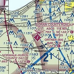
|
| Airport distance calculator |
|---|
|
|
| Sunrise and sunset |
|---|
|
Times for 18-Apr-2024
| | Local
(UTC-4) | | Zulu
(UTC) |
|---|
| Morning civil twilight | | 06:16 | | 10:16 |
| Sunrise | | 06:45 | | 10:45 |
| Sunset | | 20:12 | | 00:12 |
| Evening civil twilight | | 20:41 | | 00:41 |
|
| Current date and time |
|---|
| Zulu (UTC) | 19-Apr-2024 00:27:10 |
|---|
| Local (UTC-4) | 18-Apr-2024 20:27:10 |
|---|
|
| TAF |
|---|
KCLE
25nm E | 182101Z 1821/1924 30007KT P6SM SCT250 FM190000 15006KT P6SM BKN080 FM190800 19010KT 6SM -SHRA SCT025 BKN050 FM191300 28012G20KT P6SM VCSH BKN020 FM191700 29012G22KT P6SM BKN040
|
KMFD
29nm S | 181740Z 1818/1918 27004KT P6SM SCT250 FM190000 17008KT P6SM BKN100 FM190700 18010KT 6SM -SHRA OVC025 FM190900 18011KT 6SM -SHRA BR OVC025 WS020/21045KT FM191100 21011KT 6SM -SHRA BR BKN015 FM191300 27011G19KT P6SM VCSH OVC008 FM191600 30011G19KT P6SM OVC015
|
|
| NOTAMs |
|---|
NOTAMs are issued by the DoD/FAA and will open in a separate window not controlled by AirNav.
|
|

