FAA INFORMATION EFFECTIVE 18 APRIL 2024
Location
| FAA Identifier: | IER |
| Lat/Long: | 31-44-08.5920N 093-05-56.8910W
31-44.143200N 093-05.948183W
31.7357200,-93.0991364
(estimated) |
| Elevation: | 121 ft. / 36.9 m (surveyed) |
| Variation: | 04E (1995) |
| From city: | 2 miles S of NATCHITOCHES, LA |
| Time zone: | UTC -5 (UTC -6 during Standard Time) |
| Zip code: | 71457 |
Airport Operations
| Airport use: | Open to the public |
| Activation date: | 04/1940 |
| Control tower: | no |
| ARTCC: | HOUSTON CENTER |
| FSS: | DE RIDDER FLIGHT SERVICE STATION |
| NOTAMs facility: | IER (NOTAM-D service available) |
| Attendance: | DAWN-DUSK
FOR ARPT ATTENDANT AFT HRS CALL 318-471-2106. |
| Wind indicator: | lighted |
| Segmented circle: | no |
| Lights: | ODALS RWY 35; REIL RWY 07 AND RWY 17 PRESET LOW INTST CONSLY, TO INCR INTST ACTVT - CTAF. MIRL RWY 17/35 AND RWY 7/25 PRESET LOW INTST DUSK TO DAWN, TO INCR INTST ACTVT - CTAF |
| Beacon: | white-green (lighted land airport)
Operates sunset to sunrise. |
Airport Communications
| CTAF/UNICOM: | 122.8 |
| WX AWOS-3: | 119.025 (318-352-1575) |
| POLK APPROACH: | 125.4 [0600-2200] |
| POLK DEPARTURE: | 125.4 [0600-2200] |
Nearby radio navigation aids
| VOR radial/distance | | VOR name | | Freq | | Var |
|---|
| SWBr234/25.8 | | SAWMILL VOR/DME | | 113.75 | | 02E |
| FXUr007/(38.0) | | POLK VOR | | 108.40 | | 02E |
| NDB name | | Hdg/Dist | | Freq | | Var | | ID |
|---|
| NATCHITOCHES | | 343/4.8 | | 407 | | 04E | | OOC | --- --- -.-. |
Airport Services
| Fuel available: | 100LL JET-A1+
100LL:FUEL AVBL 24/7 WITH CC. |
| Parking: | hangars and tiedowns |
| Airframe service: | MAJOR |
| Powerplant service: | MAJOR |
| Bottled oxygen: | NONE |
| Bulk oxygen: | NONE |
Runway Information
Runway 17/35
| Dimensions: | 5003 x 150 ft. / 1525 x 46 m |
| Surface: | asphalt, in good condition |
| Weight bearing capacity: | |
| Runway edge lights: | medium intensity |
| RUNWAY 17 | | RUNWAY 35 |
| Latitude: | 31-44.380033N | | 31-43.577667N |
| Longitude: | 093-05.967400W | | 093-05.741333W |
| Elevation: | 116.4 ft. | | 120.8 ft. |
| Traffic pattern: | left | | left |
| Runway heading: | 162 magnetic, 166 true | | 342 magnetic, 346 true |
| Markings: | nonprecision, in fair condition | | nonprecision, in fair condition |
| Visual slope indicator: | 4-light PAPI on left (3.00 degrees glide path) | | 4-light PAPI on left (3.00 degrees glide path) |
| Approach lights: | | | ODALS: omnidirectional approach lighting system |
| Runway end identifier lights: | yes | | no |
| Touchdown point: | yes, no lights | | yes, no lights |
| Instrument approach: | | | LOCALIZER |
| Obstructions: | 82 ft. tree, 3600 ft. from runway, 41:1 slope to clear | | 106 ft. trees, 3612 ft. from runway, 32:1 slope to clear |
Runway 7/25
| Dimensions: | 4000 x 100 ft. / 1219 x 30 m |
| Surface: | asphalt, in good condition |
| Weight bearing capacity: | |
| Runway edge lights: | medium intensity |
| RUNWAY 7 | | RUNWAY 25 |
| Latitude: | 31-44.269767N | | 31-44.424183N |
| Longitude: | 093-06.442267W | | 093-05.691750W |
| Elevation: | 114.8 ft. | | 117.0 ft. |
| Traffic pattern: | left | | left |
| Runway heading: | 072 magnetic, 076 true | | 252 magnetic, 256 true |
| Markings: | nonprecision, in good condition | | nonprecision, in good condition |
| Visual slope indicator: | 2-light PAPI on left (3.00 degrees glide path) | | 2-light PAPI on left (3.00 degrees glide path) |
| Runway end identifier lights: | yes | | no |
| Touchdown point: | yes, no lights | | yes, no lights |
| Obstructions: | 98 ft. trees, 2049 ft. from runway, 142 ft. right of centerline, 18:1 slope to clear | | 82 ft. tree, 2091 ft. from runway, 23:1 slope to clear |
Airport Ownership and Management from official FAA records
| Ownership: | Publicly-owned |
| Owner: | CITY OF NATCHITOCHES
PO BOX 37
NATCHITOCHES, LA 71457
Phone 318-352-0994 |
| Manager: | LARRY COOPER
450 WALLENBERG DRIVE
NATCHITOCHES, LA 71457
Phone 318-352-0994 |
Airport Operational Statistics
| Aircraft based on the field: | | 40 | | Single engine airplanes: | | 31 | | Multi engine airplanes: | | 6 | | Jet airplanes: | | 2 | | Helicopters: | | 1 |
| |  | |
| Aircraft operations: avg 33/day * | | 49% | local general aviation | | 48% | transient general aviation | | 2% | air taxi | | 1% | military | | * for 12-month period ending 17 April 2020 | |
Additional Remarks
| - | GCO AVBL ON FREQ 135.075 THRU FORT POLK APCH - 4 CLICKS; AND FSS - 6 CLICKS. |
| - | FOR CD IF UNA VIA GCO CTC POLK APCH AT 337-531-2352. |
Instrument Procedures
NOTE: All procedures below are presented as PDF files. If you need a reader for these files, you should download the free Adobe Reader.NOT FOR NAVIGATION. Please procure official charts for flight.
FAA instrument procedures published for use from 18 April 2024 at 0901Z to 16 May 2024 at 0900Z.
IAPs - Instrument Approach Procedures |
|---|
| RNAV (GPS) RWY 17 | |
download (283KB) |
| RNAV (GPS) RWY 35 | |
download (281KB) |
| LOC RWY 35 | |
download (273KB) |
| NDB RWY 35 | |
download (259KB) |
| NOTE: Special Alternate Minimums apply | |
download (18KB) |
| NOTE: Special Take-Off Minimums/Departure Procedures apply | |
download |
Other nearby airports with instrument procedures:
0R7 - The Red River Airport (19 nm NW)
3R4 - Hart Airport (23 nm SW)
0R5 - David G Joyce Airport (26 nm NE)
F88 - Jonesboro Airport (34 nm NE)
L39 - Leesville Airport (36 nm S)
|
|

Road maps at:
MapQuest
Bing
Google
| Aerial photo |
|---|
WARNING: Photo may not be current or correct
 Photo by Jordan and Kirsten Eastridge
Photo taken 21-Apr-2010
Photo by Jordan and Kirsten Eastridge
Photo taken 21-Apr-2010
Do you have a better or more recent aerial photo of Natchitoches Regional Airport that you would like to share? If so, please send us your photo.
|
| Sectional chart |
|---|
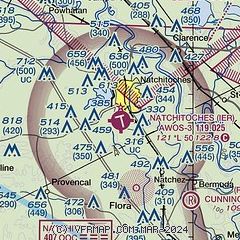
|
| Airport distance calculator |
|---|
|
|
| Sunrise and sunset |
|---|
|
Times for 24-Apr-2024
| | Local
(UTC-5) | | Zulu
(UTC) |
|---|
| Morning civil twilight | | 06:08 | | 11:08 |
| Sunrise | | 06:34 | | 11:34 |
| Sunset | | 19:47 | | 00:47 |
| Evening civil twilight | | 20:13 | | 01:13 |
|
| Current date and time |
|---|
| Zulu (UTC) | 25-Apr-2024 04:57:37 |
|---|
| Local (UTC-5) | 24-Apr-2024 23:57:37 |
|---|
|
| METAR |
|---|
| KIER | 250435Z AUTO 00000KT 10SM CLR 19/19 A3011 RMK AO2 T01850185
|
KAQV
18nm W | 250447Z AUTO 00000KT 6SM BR CLR 18/17 A3008 RMK AO2 SLP185 T01830167
|
|
| TAF |
|---|
KPOE
36nm S | 242300Z 2423/2605 VRB06KT 9999 SCT080 QNH3004INS BECMG 2500/2501 VRB06KT 9999 BKN045 BKN060 QNH3005INS BECMG 2503/2504 VRB06KT 9999 BKN015 OVC025 QNH3007INS BECMG 2508/2509 VRB06KT 8000 BR BKN007 QNH3007INS TEMPO 2509/2513 3200 BR OVC004 BECMG 2515/2516 17009KT 9999 NSW BKN012 QNH3009INS BECMG 2516/2517 16012G18KT 9999 BKN025 BKN250 QNH3005INS BECMG 2518/2519 17012G18KT 9999 BKN045 BKN250 QNH2995INS BECMG 2600/2601 16009KT 9999 BKN015 QNH2995INS BECMG 2604/2605 16009KT 9999 BKN008 OVC015 QNH2997
|
KAEX
36nm SE | 241739Z 2418/2518 VRB04KT P6SM FEW060 FEW150 FM242100 17005KT P6SM OVC100 FM250900 13002KT P6SM FEW250 TEMPO 2509/2513 VRB03KT 2SM BR BKN015 FM251400 13007KT P6SM BKN050
|
|
| NOTAMs |
|---|
NOTAMs are issued by the DoD/FAA and will open in a separate window not controlled by AirNav.
|
|


