FAA INFORMATION EFFECTIVE 18 APRIL 2024
Location
| FAA Identifier: | JMR |
| Lat/Long: | 45-53-30.8340N 093-16-22.6170W
45-53.513900N 093-16.376950W
45.8918983,-93.2729492
(estimated) |
| Elevation: | 1032.8 ft. / 314.8 m (surveyed) |
| Variation: | 00W (2020) |
| From city: | 1 mile NE of MORA, MN |
| Time zone: | UTC -5 (UTC -6 during Standard Time) |
| Zip code: | 55051 |
Airport Operations
| Airport use: | Open to the public |
| Activation date: | 05/1947 |
| Control tower: | no |
| ARTCC: | MINNEAPOLIS CENTER |
| FSS: | PRINCETON FLIGHT SERVICE STATION |
| NOTAMs facility: | JMR (NOTAM-D service available) |
| Attendance: | UNATNDD |
| Wind indicator: | lighted |
| Segmented circle: | no |
| Lights: | ACTVT REIL RWY 17 & 35; PAPI RWY 17 & 35 - CTAF. MIRL RWY 17/35 PRESET TO LOW INTST; TO INCR INTST - CTAF. |
| Beacon: | white-green (lighted land airport)
Operates sunset to sunrise. |
Airport Communications
| CTAF/UNICOM: | 122.8 |
| WX AWOS-3: | 123.925 (320-679-1629) |
| WX AWOS-3 at 04W (18 nm NE): | 118.225 (320-384-6169) |
| WX AWOS-3 at ROS (18 nm SE): | 118.8 (320-358-3339) |
- APCH/DEP SVC PRVDD BY MINNAEPOLIS ARTCC ON FREQS 121.05/235.775 (PRINCETON RCAG).
Nearby radio navigation aids
| VOR radial/distance | | VOR name | | Freq | | Var |
|---|
| STCr055/38.8 | | ST CLOUD VOR/DME | | 112.10 | | 03E |
| NDB name | | Hdg/Dist | | Freq | | Var | | ID |
|---|
| BIG DOCTOR | | 277/38.1 | | 203 | | 01W | | BXR | -... -..- .-. |
Airport Services
| Fuel available: | 100LL JET-A
100LL:FUEL AVBL H24 WITH CREDIT CARD. |
| Parking: | tiedowns |
| Airframe service: | NONE |
| Powerplant service: | NONE |
| Bottled oxygen: | NONE |
| Bulk oxygen: | NONE |
Runway Information
Runway 17/35
| Dimensions: | 4794 x 75 ft. / 1461 x 23 m |
| Surface: | asphalt, in good condition |
| Runway edge lights: | medium intensity |
| RUNWAY 17 | | RUNWAY 35 |
| Latitude: | 45-53.742960N | | 45-52.962400N |
| Longitude: | 093-16.352062W | | 093-16.189380W |
| Elevation: | 998.4 ft. | | 1009.5 ft. |
| Traffic pattern: | left | | left |
| Runway heading: | 172 magnetic, 172 true | | 352 magnetic, 352 true |
| Markings: | nonprecision, in good condition | | nonprecision, in good condition |
| Visual slope indicator: | 4-light PAPI on left (3.00 degrees glide path) | | 4-light PAPI on left (3.00 degrees glide path) |
| Runway end identifier lights: | yes | | yes |
| Touchdown point: | yes, no lights | | yes, no lights |
Runway 11/29
| Dimensions: | 3152 x 80 ft. / 961 x 24 m |
| Surface: | turf, in poor condition
GRVL PATCHES AND BARE SPOTS. |
| Runway edge markings: | MKD WITH YELLOW CONES. |
| RUNWAY 11 | | RUNWAY 29 |
| Latitude: | 45-53.873665N | | 45-53.644657N |
| Longitude: | 093-16.871683W | | 093-16.205498W |
| Elevation: | 1032.8 ft. | | 994.5 ft. |
| Traffic pattern: | left | | left |
| Runway heading: | 116 magnetic, 116 true | | 296 magnetic, 296 true |
| Markings: | NSTD, in good condition | | NSTD, in good condition |
| Touchdown point: | yes, no lights | | yes, no lights |
Airport Ownership and Management from official FAA records
| Ownership: | Publicly-owned |
| Owner: | CITY OF MORA
101 LAKE STREET SOUTH
MORA, MN 55051
Phone 320-679-1511 |
| Manager: | JOE KOHLGRAF
101 LAKE STREET SOUTH
MORA, MN 55051
Phone (612) 390-8217
EMAIL ADDRESS: JOE.KOHLGRAF@CITYOFMORA.COM (ALL LOWER CASE) |
Airport Operational Statistics
| Aircraft based on the field: | | 26 | | Single engine airplanes: | | 25 | | Jet airplanes: | | 1 |
| |  | |
| Aircraft operations: avg 41/day * | | 73% | local general aviation | | 26% | transient general aviation | | <1% | air taxi | | * for 12-month period ending 31 August 2017 | |
Additional Remarks
| - | WATERFOWL INVOF ARPT. |
| - | ULTRALIGHTS ON & INVOF ARPT. |
| - | FOR CD CTC MINNEAPOLIS ARTCC AT 651-463-5588. |
Instrument Procedures
NOTE: All procedures below are presented as PDF files. If you need a reader for these files, you should download the free Adobe Reader.NOT FOR NAVIGATION. Please procure official charts for flight.
FAA instrument procedures published for use from 18 April 2024 at 0901Z to 16 May 2024 at 0900Z.
IAPs - Instrument Approach Procedures |
|---|
| RNAV (GPS) RWY 35 | |
download (223KB) |
| NOTE: Special Alternate Minimums apply | |
download (52KB) |
| NOTE: Special Take-Off Minimums/Departure Procedures apply | |
download (270KB) |
Other nearby airports with instrument procedures:
04W - Field of Dreams Airport (18 nm NE)
KROS - Rush City Regional Airport (18 nm SE)
KCBG - Cambridge Municipal Airport (20 nm S)
KPNM - Princeton Municipal Airport (24 nm SW)
KGTG - Grantsburg Municipal Airport (26 nm E)
|
|

Road maps at:
MapQuest
Bing
Google
| Aerial photo |
|---|
WARNING: Photo may not be current or correct
 Photo taken 27-Jul-2007
Do you have a better or more recent aerial photo of Mora Municipal Airport that you would like to share? If so, please send us your photo.
|
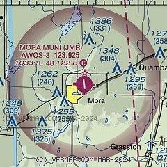
| Sectional chart |
|---|
|
| Airport distance calculator |
|---|
|
|
| Sunrise and sunset |
|---|
|
Times for 25-Apr-2024
| | Local
(UTC-5) | | Zulu
(UTC) |
|---|
| Morning civil twilight | | 05:37 | | 10:37 |
| Sunrise | | 06:09 | | 11:09 |
| Sunset | | 20:13 | | 01:13 |
| Evening civil twilight | | 20:45 | | 01:45 |
|
| Current date and time |
|---|
| Zulu (UTC) | 25-Apr-2024 14:07:07 |
|---|
| Local (UTC-5) | 25-Apr-2024 09:07:07 |
|---|
|
| METAR |
|---|
| KJMR | 251355Z AUTO 16006KT 10SM CLR 11/M03 A3022 RMK AO2
|
K04W
18nm NE | 251355Z AUTO 15007KT 10SM CLR 10/M02 A3022 RMK AO2
|
KROS
18nm SE | 251355Z AUTO 15007KT 10SM CLR 11/M04 A3021 RMK AO2 T01121038
|
KCBG
20nm S | 251355Z AUTO 16009G15KT 10SM CLR 11/02 A3019 RMK AO2
|
|
| TAF |
|---|
KSTC
38nm SW | 251140Z 2512/2612 12006KT P6SM FEW120 FM251600 15018G27KT P6SM FEW150 FM260900 13015G25KT P6SM OVC060
|
KBRD
47nm NW | 251124Z 2512/2612 15007G14KT P6SM SKC FM251500 16014G21KT P6SM SCT070 FM260200 14010KT P6SM SCT090 WS020/15045KT
|
|
| NOTAMs |
|---|
NOTAMs are issued by the DoD/FAA and will open in a separate window not controlled by AirNav.
|
|

