FAA INFORMATION EFFECTIVE 18 APRIL 2024
Location
| FAA Identifier: | JYO |
| Lat/Long: | 39-04-40.7000N 077-33-27.0000W
39-04.678333N 077-33.450000W
39.0779722,-77.5575000
(estimated) |
| Elevation: | 389.5 ft. / 118.7 m (surveyed) |
| Variation: | 10W (1995) |
| From city: | 3 miles S of LEESBURG, VA |
| Time zone: | UTC -4 (UTC -5 during Standard Time) |
| Zip code: | 20175 |
Airport Operations
| Airport use: | Open to the public |
| Activation date: | 10/1964 |
| Control tower: | yes |
| ARTCC: | WASHINGTON CENTER |
| FSS: | LEESBURG FLIGHT SERVICE STATION |
| NOTAMs facility: | JYO (NOTAM-D service available) |
| Attendance: | 0600-2100 |
| Pattern altitude: | 1199.5 ft. MSL |
| Wind indicator: | yes |
| Segmented circle: | yes |
| Lights: | WHEN ATCT CLSD ACTVT ODALS RWY 17; REIL RWY 17 & 35; PAPI RWY 17 & 35; HIRL RWY 17/35 - CTAF. |
| Beacon: | white-green (lighted land airport)
Operates sunset to sunrise. |
| International operations: | customs landing rights airport
US CUST AVBL MON-SUN 0600-2100. CALL COMMAND CNTR
703-661-2800 FOR APNTMT. 24 HR NOTICE RQRD. |
Airport Communications
| CTAF: | 127.5 |
| UNICOM: | 122.975 |
| WX AWOS-3: | 125.225 (703-777-3781) |
| LEESBURG TOWER GROUND: | 120.5 [1300-2300Z++] |
| LEESBURG TOWER TOWER: | 127.5 [1300-2300Z++] |
| POTOMAC APPROACH: | 125.05 |
| POTOMAC DEPARTURE: | 125.05 |
| CLEARANCE DELIVERY: | 118.55 ;WHEN JYO TWR CLSD 120.5 |
| CLTCH DP: | 125.05 |
| COATT STAR: | 128.525 |
| DOCCS STAR: | 120.45 |
| GIBBZ STAR: | 120.45 |
| HYPER STAR: | 133.0 |
| JDUBB DP: | 125.05 |
| PTOMC DP: | 125.05 |
| SCRAM DP: | 125.05 |
| TRSTN STAR: | 126.75 |
| WX ASOS at IAD (9 nm SE): | 134.85 (703-661-2990) |
| WX AWOS-3PT at GAI (19 nm E): | 128.275 (301-977-2971) |
- TWR OPNS CURRENTLY SUPPORTED BY MOBILE/REMOTE ATCT SYS.
Nearby radio navigation aids
| VOR radial/distance | | VOR name | | Freq | | Var |
|---|
| AMLr342/9.6 | | ARMEL VOR/DME | | 113.50 | | 08W |
| FDKr211/(21.8) | | FREDERICK VOR | | 109.00 | | 08W |
| MRBr151/22.9 | | MARTINSBURG VORTAC | | 112.10 | | 07W |
| DCAr307/27.6 | | WASHINGTON VOR/DME | | 111.00 | | 09W |
| CSNr035/29.9 | | CASANOVA VORTAC | | 116.30 | | 06W |
| LDNr072/33.1 | | LINDEN VORTAC | | 114.30 | | 06W |
| ADWr307/36.1 | | ANDREWS VORTAC | | 113.10 | | 10W |
| EMIr235/36.7 | | WESTMINSTER VORTAC | | 117.90 | | 08W |
| HGRr167/(39.7) | | HAGERSTOWN VOR | | 109.80 | | 07W |
| NDB name | | Hdg/Dist | | Freq | | Var | | ID |
|---|
| GEORGETOWN | | 303/22.1 | | 323 | | 09W | | GTN | --. - -. |
| OXONN | | 318/31.0 | | 332 | | 11W | | DCA | -.. -.-. .- |
| DAVEE | | 329/32.6 | | 223 | | 09W | | DAA | -.. .- .- |
| ELLICOTT | | 262/38.4 | | 371 | | 11W | | FND | ..-. -. -.. |
Airport Services
| Fuel available: | 100LL JET-A |
| Parking: | hangars and tiedowns |
| Airframe service: | MAJOR |
| Powerplant service: | MAJOR |
| Bottled oxygen: | LOW |
| Bulk oxygen: | NONE |
Runway Information
Runway 17/35
| Dimensions: | 5500 x 100 ft. / 1676 x 30 m |
| Surface: | asphalt/grooved, in good condition |
| Weight bearing capacity: | | PCN 63 /F/A/W/U | | Single wheel: | 30.0 | | Double wheel: | 70.0 |
|
| Runway edge lights: | high intensity |
| RUNWAY 17 | | RUNWAY 35 |
| Latitude: | 39-05.107107N | | 39-04.249002N |
| Longitude: | 077-33.636410W | | 077-33.263382W |
| Elevation: | 377.6 ft. | | 387.2 ft. |
| Traffic pattern: | left | | left |
| Runway heading: | 171 magnetic, 161 true | | 351 magnetic, 341 true |
| Markings: | precision, in good condition | | nonprecision, in good condition |
| Visual slope indicator: | 4-light PAPI on left (3.00 degrees glide path) | | 4-light PAPI on left (3.00 degrees glide path) |
| Approach lights: | ODALS: omnidirectional approach lighting system
NSTD ODALS, 3 LGT CONFIGURATION. | | |
| Runway end identifier lights: | yes | | yes |
| Touchdown point: | yes, no lights | | yes, no lights |
| Instrument approach: | ILS/DME | | |
| Obstructions: | 25 ft. tree, 812 ft. from runway, 374 ft. left of centerline, 24:1 slope to clear | | 45 ft. tree, 2027 ft. from runway, 75 ft. left of centerline, 40:1 slope to clear |
Airport Ownership and Management from official FAA records
| Ownership: | Publicly-owned |
| Owner: | TOWN OF LEESBURG
25 WEST MARKET ST., 25 WEST MARKET ST.
LEESBURG, VA 20176
Phone 703-777-2420 |
| Manager: | SCOTT COFFMAN
1001 SYCOLIN ROAD, SE, SUITE 7
LEESBURG, VA 20175
Phone 703-737-7125 |
Airport Operational Statistics
| Aircraft based on the field: | | 249 | | Single engine airplanes: | | 200 | | Multi engine airplanes: | | 23 | | Jet airplanes: | | 21 | | Helicopters: | | 4 | | Gliders airplanes: | | 1 |
| |  | |
| Aircraft operations: avg 224/day * | | 51% | local general aviation | | 47% | transient general aviation | | <1% | air taxi | | <1% | commercial | | <1% | military | | * for 12-month period ending 31 December 2022 | |
Additional Remarks
| - | RAMP FENCE S/W SIDE RAMPS LEAD IN LINES ON WEST RAMP NA. |
| - | PSBL THERMAL PLUMES FM PWR PLANT 1.3 NM SSE. |
| - | FOR CD WHEN ATCT CLSD, CTC POTOMAC APCH 118.55 OR 866-709-4993. |
| - | BIRDS & DEER ON & INVOF ARPT. |
| - | HEL ACT ON & INVOF ARPT. |
| - | CALM WIND USE RWY 17. |
Instrument Procedures
NOTE: All procedures below are presented as PDF files. If you need a reader for these files, you should download the free Adobe Reader.NOT FOR NAVIGATION. Please procure official charts for flight.
FAA instrument procedures published for use from 18 April 2024 at 0901Z to 16 May 2024 at 0900Z.
STARs - Standard Terminal Arrivals |
|---|
| DOCCS THREE | |
2 pages:
[1] [2] (357KB) |
| GIBBZ FIVE (RNAV) **NEW** | |
2 pages:
[1] [2] (518KB) |
| HYPER NINE (RNAV) **NEW** | |
2 pages:
[1] [2] (384KB) |
| HYPER NINE (RNAV), CONT.2 **NEW** | |
download (165KB) |
| PRIVO THREE | |
2 pages:
[1] [2] (267KB) |
| TRSTN THREE (RNAV) | |
download (210KB) |
IAPs - Instrument Approach Procedures |
|---|
| ILS OR LOC RWY 17 | |
download (397KB) |
| RNAV (GPS) RWY 17 | |
download (344KB) |
| NOTE: Special Alternate Minimums apply | |
download (166KB) |
Departure Procedures |
|---|
| CLTCH THREE (RNAV) | |
download (185KB) |
| JDUBB FOUR (RNAV) | |
download (189KB) |
| PTOMC TWO (RNAV) | |
download (262KB) |
| SCRAM SIX (RNAV) | |
download (178KB) |
| NOTE: Special Take-Off Minimums/Departure Procedures apply | |
download (366KB) |
Other nearby airports with instrument procedures:
KIAD - Washington Dulles International Airport (9 nm SE)
9VA5 - Bluegrass Heliport (16 nm W)
KGAI - Montgomery County Airpark (19 nm E)
W50 - Davis Airport (21 nm NE)
KHEF - Manassas Regional Airport/Harry P. Davis Field (22 nm S)
|
|

Road maps at:
MapQuest
Bing
Google
| Aerial photo |
|---|
WARNING: Photo may not be current or correct
 Photographer: Leo Schefer
Pilot: Charles Schefer
Photo taken 20-Sep-2009
Do you have a better or more recent aerial photo of Leesburg Executive Airport that you would like to share? If so, please send us your photo.
|
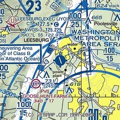
| Sectional chart |
|---|
|
CAUTION: Diagram may not be current
 Download PDF
of official airport diagram from the FAA
| Airport distance calculator |
|---|
|
|
| Sunrise and sunset |
|---|
|
Times for 23-Apr-2024
| | Local
(UTC-4) | | Zulu
(UTC) |
|---|
| Morning civil twilight | | 05:54 | | 09:54 |
| Sunrise | | 06:22 | | 10:22 |
| Sunset | | 19:55 | | 23:55 |
| Evening civil twilight | | 20:23 | | 00:23 |
|
| Current date and time |
|---|
| Zulu (UTC) | 23-Apr-2024 07:56:19 |
|---|
| Local (UTC-4) | 23-Apr-2024 03:56:19 |
|---|
|
| METAR |
|---|
| KJYO | 230735Z AUTO 00000KT 10SM CLR 05/01 A3013 RMK AO2
|
KIAD
10nm SE | 230652Z 00000KT 10SM CLR 03/00 A3012 RMK AO2 SLP199 T00330000
|
KGAI
19nm E | 230656Z AUTO 00000KT 10SM CLR 04/01 A3012 RMK AO2 SLP217 T00390006
|
|
| TAF |
|---|
KIAD
10nm SE | 230537Z 2306/2412 15003KT P6SM SKC FM231400 19007KT P6SM FEW060 FEW250 FM231800 20011G18KT P6SM FEW060 FEW250 FM240000 18008G15KT P6SM SCT100 BKN200
|
|
| NOTAMs |
|---|
NOTAMs are issued by the DoD/FAA and will open in a separate window not controlled by AirNav.
|
|
FBO, Fuel Providers, and Aircraft Ground Support |
|---|
| | 
Business Name | |
Contact | |
Services / Description | |
Fuel Prices | |
Comments | |
|---|


|
|
ASRI 128.95
703-889-8558
[web site]
[email] |
|
Located at the Main terminal next to U.S. Customs, off of A3! COMPETITIVE fuel pricing, Need overnight hangar? We have three corporate hangars! Years of experience, excellent safety record! Give us a call 703.889.8558!


|
|
 | | 100LL | Jet A | | FS | | $6.80 | | $6.30 | | GUARANTEED |  | MEMBERS
ONLY
Discounts |
| |
|
|

6 read write
|
|


|
|
ASRI 131.20
703-665-3000
[web site]
[email] |
|
Brand-new climate-controlled hangar; Highly competitive fuel prices; Heated Parking Garage; Complete line service offered; Modern, upscale lounge with shower facilities

|
|
|
|
10 read write
|
|
Alternatives at nearby airports
IMPORTANT: Note that the FBOs below are NOT at KJYO but at other nearby airports. Do not expect services from these FBOs to be available at KJYO. |
 |
|
304-262-2507
toll-free 800-550-2507
[web site]
[email] |
|
At KMRB (Eastern WV Regional Airport/Shepherd Field), 28 miles NW
Welcome to the Eastern West Virginia Regional Airport located in the beautiful Shenandoah Valley and with proximity to Washington, Baltimore and charming horse and wine country in between. Whether you base your operations here at MRB or you want to take in all the sights locally or in nearby Virginia, Maryland or Pennsylvania, our gracious staff always goes the extra mile. Located 37 nm northwest of Washington-Dulles International Airport (IAD), MRB is less than 90 minutes-drive time to both Washington and Baltimore and outside the D.C. Special Flight Rules Area
|
|
| Located at KMRB | | | 100LL | Jet A | | FS | | $6.99 | | $6.69 | | SS | | $6.59 | | --- | | GUARANTEED | | MEMBERS
ONLY
Discounts |
| |
|
|

1 read write
|
|
 |
|
ASRI 131.625
703-574-0700
[web site]
[email] |
|
At KHEF (Manassas Regional Airport/Harry P. Davis Field), 22 miles S
Chantilly Air has been serving the DC metro area for over 30 years. Over 5 acres of Ramp Space able to safely accommodate your aircraft. FAA Diamond Award Part 145 Repair Station. Pilots lounge with fully equipped gym, showers and soundproof snooze rooms. New crew cars. Two conference rooms available. VIP waiting room for your passenger's privacy.
Newly constructed 85,000 sq. ft. FBO and Hangar facility,
Duncan Aviation satellite shop located onsite for all your AOG avionics and maintenance needs
|
|
| Located at KHEF |  | | 100LL | Jet A | | FS | | $7.16 | | $6.15 | | GUARANTEED | | MEMBERS
ONLY
Discounts |
| |
|
|
7 read write
|
|
 |
|
ASRI 128.90
703-392-5387
[web site]
[email] |
|
At KHEF (Manassas Regional Airport/Harry P. Davis Field), 22 miles S
Full service FBO, open 24/7. No Landing Fee. Handling Fee waived with fuel. Avoid the heavy traffic and high pricing at Washington Dulles-IAD and join the numerous executives and administrators that use APP Jet Center as their D.C. gateway. Our NATA Safety 1st-trained line team and experienced customer service representatives will have you and your clients quickly on their way.
|
|
| Located at KHEF |  | | 100LL | Jet A | | FS | | $7.07 | | $5.95 | | GUARANTEED | | MEMBER
PRICING |
| | FS | | $6.82 | | $5.70 |
|
|
1 read write
|
|

|
| |
Would you like to see your business listed on this page? |
|---|
| | If your business provides an interesting product or service to pilots, flight crews, aircraft, or users of the Leesburg Executive Airport, you should consider listing it here. To start the listing process, click on the button below

|


