FAA INFORMATION EFFECTIVE 18 APRIL 2024
Location
| FAA Identifier: | CPR |
| Lat/Long: | 42-54-21.1000N 106-27-49.1000W
42-54.351667N 106-27.818333W
42.9058611,-106.4636389
(estimated) |
| Elevation: | 5344 ft. / 1628.9 m (surveyed) |
| Variation: | 12E (1990) |
| From city: | 7 miles NW of CASPER, WY |
| Time zone: | UTC -6 (UTC -7 during Standard Time) |
| Zip code: | 82604 |
Airport Operations
| Airport use: | Open to the public |
| Activation date: | 11/1943 |
| Control tower: | yes |
| ARTCC: | DENVER CENTER |
| FSS: | CASPER FLIGHT SERVICE STATION |
| NOTAMs facility: | CPR (NOTAM-D service available) |
| Attendance: | CONTINUOUS |
| Wind indicator: | lighted |
| Segmented circle: | yes |
| Lights: | ATC-CTL. WHEN ATCT CLSD ACTVT MALSR RWY 03 & 08; REIL RWY 21; PAPI RWY 03 & 26; HIRL RWY 03/21 & 08/26; TWY LGTS - CTAF. |
| Beacon: | white-green (lighted land airport)
Operates sunset to sunrise. |
| Fire and rescue: | ARFF index B |
| International operations: | customs landing rights airport |
Airport Communications
| CTAF: | 118.3 |
| UNICOM: | 122.95 |
| ATIS: | 126.15 |
| WX ASOS: | PHONE 307-472-8960 |
| CASPER GROUND: | 121.9 [0500-2100] |
| CASPER TOWER: | 118.3 257.8 [0500-2100] |
| CASPER APPROACH: | 120.65 354.1 [0500-2100] |
| DENVER ARTCC APPROACH: | 119.0 [2100-0500] |
| CASPER DEPARTURE: | 120.65 354.1 [0500-2100] |
| DENVER ARTCC DEPARTURE: | 119.0 [2100-0500] |
| CLEARANCE DELIVERY: | 121.9 257.8 |
| IC: | 120.65 |
- APCH/DEP CTL SVC PRVDD BY DENVER ARTCC (ZDV) ON FREQS 135.6/363.025 (CASPER RCAG) WHEN CASPER APCH CTL (CPR) CLSD.
- FREQ 121.5 NOT AVBL.
- COMMUNICATIONS PRVDD BY CASPER RADIO ON FREQS 122.6 (CASPER RCO).
Nearby radio navigation aids
| VOR radial/distance | | VOR name | | Freq | | Var |
|---|
| DDYr204/13.8 | | MUDDY MOUNTAIN VOR/DME | | 116.20 | | 12E |
Airport Services
| Fuel available: | 100LL JET-A |
| Parking: | hangars and tiedowns |
| Airframe service: | MAJOR |
| Powerplant service: | MAJOR |
| Bottled oxygen: | HIGH/LOW |
| Bulk oxygen: | HIGH/LOW |
Runway Information
Runway 3/21
| Dimensions: | 10165 x 150 ft. / 3098 x 46 m |
| Surface: | asphalt/grooved, in good condition |
| Weight bearing capacity: | | PCN 46 /F/B/X/T | | Single wheel: | 130.0 | | Double wheel: | 170.0 | | Double tandem: | 270.0 |
|
| Runway edge lights: | high intensity |
| RUNWAY 3 | | RUNWAY 21 |
| Latitude: | 42-53.604143N | | 42-54.809697N |
| Longitude: | 106-28.501857W | | 106-26.923943W |
| Elevation: | 5324.2 ft. | | 5326.1 ft. |
| Traffic pattern: | left | | left |
| Runway heading: | 032 magnetic, 044 true | | 212 magnetic, 224 true |
| Declared distances: | TORA:10165 TODA:10165 ASDA:10165 LDA:10165 | | TORA:10165 TODA:10165 ASDA:10165 LDA:10165 |
| Markings: | precision, in good condition | | precision, in good condition |
| Visual slope indicator: | 4-light PAPI on right (3.00 degrees glide path) | | 4-box VASI on left (3.00 degrees glide path) |
| RVR equipment: | touchdown | | rollout |
| Approach lights: | MALSR: 1,400 foot medium intensity approach lighting system with runway alignment indicator lights | | |
| Runway end identifier lights: | | | yes |
| Touchdown point: | yes, no lights | | yes, no lights |
| Instrument approach: | ILS | | |
Runway 8/26
| Dimensions: | 8679 x 150 ft. / 2645 x 46 m |
| Surface: | asphalt/grooved, in fair condition |
| Weight bearing capacity: | | PCN 44 /F/B/X/T | | Single wheel: | 85.0 | | Double wheel: | 140.0 | | Double tandem: | 260.0 |
|
| Runway edge lights: | high intensity |
| RUNWAY 8 | | RUNWAY 26 |
| Latitude: | 42-54.509092N | | 42-54.536623N |
| Longitude: | 106-28.914332W | | 106-26.971550W |
| Elevation: | 5343.8 ft. | | 5323.5 ft. |
| Traffic pattern: | left | | left |
| Runway heading: | 077 magnetic, 089 true | | 257 magnetic, 269 true |
| Declared distances: | TORA:8679 TODA:8679 ASDA:8679 LDA:8679 | | TORA:8679 TODA:8679 ASDA:8679 LDA:8679 |
| Markings: | precision, in good condition | | precision, in good condition |
| Visual slope indicator: | 4-box VASI on right (3.00 degrees glide path) | | 4-light PAPI on right (3.00 degrees glide path) |
| RVR equipment: | touchdown | | rollout |
| Approach lights: | MALSR: 1,400 foot medium intensity approach lighting system with runway alignment indicator lights | | |
| Runway end identifier lights: | | | yes |
| Touchdown point: | yes, no lights | | yes, no lights |
| Instrument approach: | ILS | | |
Airport Ownership and Management from official FAA records
| Ownership: | Publicly-owned |
| Owner: | COUNTY BOARD OF COMMISSIONERS
8500 AIRPORT PARKWAY, SUITE 208
CASPER, WY 82604
Phone 307-472-6688 |
| Manager: | GLENN JANUSKA
8500 AIRPORT PARKWAY, SUITE 208
CASPER, WY 82604
Phone 307-472-6688 |
Airport Operational Statistics
| Aircraft based on the field: | | 123 | | Single engine airplanes: | | 106 | | Multi engine airplanes: | | 9 | | Jet airplanes: | | 2 | | Helicopters: | | 6 |
| |  | |
| Aircraft operations: avg 103/day * | | 43% | transient general aviation | | 27% | local general aviation | | 21% | air taxi | | 7% | commercial | | 3% | military | | * for 12-month period ending 31 December 2023 | |
Additional Remarks
| - | EMERG PWR AVBL RYS 08/26 & 03/21. |
| - | RY 08/26 & RY 03/21 HAVE LGTD DISTANCE REMAINING SIGNS. |
| - | 225 FT CRANE 1 NM NE OF ARPT. |
| - | RWYS CLSD TO FSL, TGL, AND PLA ACFT MORE THAN 250000 LBS EXC FOR 4 HRS PPR 307-995-3949. |
| - | FOR CD CTC CASPER APCH AT 307-472-8940, WHEN APCH CLSD CTC DENVER ARTCC AT 303-651-4257. |
Instrument Procedures
NOTE: All procedures below are presented as PDF files. If you need a reader for these files, you should download the free Adobe Reader.NOT FOR NAVIGATION. Please procure official charts for flight.
FAA instrument procedures published for use from 18 April 2024 at 0901Z to 16 May 2024 at 0900Z.
IAPs - Instrument Approach Procedures |
|---|
| ILS OR LOC RWY 03 | |
download (445KB) |
| RNAV (GPS) RWY 03 | |
download (319KB) |
| RNAV (GPS) RWY 08 | |
download (279KB) |
| RNAV (GPS) RWY 21 | |
download (262KB) |
| RNAV (GPS) RWY 26 | |
download (266KB) |
| VOR/DME RWY 21 | |
download (229KB) |
| NOTE: Special Alternate Minimums apply | |
download (86KB) |
Departure Procedures |
|---|
| ALCOS SIX | |
download (195KB) |
| CASPER THREE | |
download (262KB) |
| NOTE: Special Take-Off Minimums/Departure Procedures apply | |
download (223KB) |
Other nearby airports with instrument procedures:
KDGW - Converse County Airport (48 nm E)
KRWL - Rawlins Municipal Airport/Harvey Field (74 nm SW)
KEAN - Phifer Airfield (85 nm SE)
KGUR - Camp Guernsey Airport (86 nm SE)
KRIW - Central Wyoming Regional Airport (88 nm W)
|
|

Road maps at:
MapQuest
Bing
Google
| Aerial photo |
|---|
WARNING: Photo may not be current or correct

Do you have a better or more recent aerial photo of Casper/Natrona County International Airport that you would like to share? If so, please send us your photo.
|
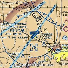
| Sectional chart |
|---|
|
CAUTION: Diagram may not be current
 Download PDF
of official airport diagram from the FAA
| Airport distance calculator |
|---|
|
|
| Sunrise and sunset |
|---|
|
Times for 23-Apr-2024
| | Local
(UTC-6) | | Zulu
(UTC) |
|---|
| Morning civil twilight | | 05:41 | | 11:41 |
| Sunrise | | 06:11 | | 12:11 |
| Sunset | | 19:57 | | 01:57 |
| Evening civil twilight | | 20:27 | | 02:27 |
|
| Current date and time |
|---|
| Zulu (UTC) | 23-Apr-2024 08:01:49 |
|---|
| Local (UTC-6) | 23-Apr-2024 02:01:49 |
|---|
|
| METAR |
|---|
| KCPR | 230753Z AUTO 00000KT 10SM CLR M02/M07 A3006 RMK AO2 SLP165 T10171072
|
|
| TAF |
|---|
| KCPR | 230520Z 2306/2406 03008KT P6SM SCT150 FM231900 09010KT P6SM BKN220
|
|
| NOTAMs |
|---|
NOTAMs are issued by the DoD/FAA and will open in a separate window not controlled by AirNav.
|
|


