FAA INFORMATION EFFECTIVE 18 APRIL 2024
Location
| FAA Identifier: | CYS |
| Lat/Long: | 41-09-20.3000N 104-48-37.7000W
41-09.338333N 104-48.628333W
41.1556389,-104.8104722
(estimated) |
| Elevation: | 6159.9 ft. / 1877.5 m (surveyed) |
| Variation: | 10E (2005) |
| From city: | 1 mile N of CHEYENNE, WY |
| Time zone: | UTC -6 (UTC -7 during Standard Time) |
| Zip code: | 82001 |
Airport Operations
| Airport use: | Open to the public |
| Activation date: | 10/1937 |
| Control tower: | yes |
| ARTCC: | DENVER CENTER |
| FSS: | CASPER FLIGHT SERVICE STATION |
| NOTAMs facility: | CYS (NOTAM-D service available) |
| Attendance: | 0600-2200 |
| Wind indicator: | lighted |
| Segmented circle: | yes |
| Lights: | ACTVT MALSR RWY 27; REIL RWY 09, 13, 31; PAPI RWY 09, 27, 13, 31; HIRL RWY 09/27; MIRL RWY 13/31 - CTAF |
| Beacon: | white-green (lighted land airport)
Operates sunset to sunrise. |
| Landing fee: | no, TIEDOWN FEE. |
| Fire and rescue: | ARFF index A |
| Airline operations: | PPR FOR UNSKED ACR OPNS WHEN ATCT CLSD CALL AMGR 307-638-3872. |
Airport Communications
| CTAF: | 118.7 |
| UNICOM: | 122.95 |
| ATIS: | 134.425 278.3 |
| WX ASOS: | PHONE 307-632-7680 |
| CHEYENNE GROUND: | 121.9 254.275 [0600-2200] |
| CHEYENNE TOWER: | 118.7 257.8 [0600-2200] |
| CHEYENE APPROACH: | 124.55 263.075 [0600-2200] |
| CHEYENE DEPARTURE: | 124.55 263.075 [0600-2200] |
| ANG COMD POST: | 257.1 |
| ANG OPS: | 257.1 |
| ARNG OPS: | 134.1 ;CALL STEAMBOAT 242.4 ;CALL STEAMBOAT |
| EMERG: | 121.5 243.0 |
- APCH/DEP CTL SVC PRVDD BY DENVER ARTCC (ZDV) ON FREQS 125.9/284.7 (CHEYENNE RCAG) WHEN CHEYENNE APCH CTL (CYS) CLSD.
Nearby radio navigation aids
| VOR radial/distance | | VOR name | | Freq | | Var |
|---|
| CYSr194/3.7 | | CHEYENNE VORTAC | | 113.10 | | 13E |
Airport Services
| Fuel available: | 100LL JET-A JET-A1
100LL:AFTER HOURS FUEL CALL 307-634-7079. |
| Parking: | hangars and tiedowns |
| Airframe service: | MINOR |
| Powerplant service: | MINOR |
| Bottled oxygen: | NONE |
| Bulk oxygen: | HIGH/LOW |
Runway Information
Runway 9/27
| Dimensions: | 9270 x 150 ft. / 2825 x 46 m |
| Surface: | concrete/grooved, in fair condition |
| Weight bearing capacity: | | Single wheel: | 75.0 | | Double wheel: | 140.0 | | Double tandem: | 150.0 | | Dual double tandem: | 250.0 |
|
| Runway edge lights: | high intensity |
| RUNWAY 9 | | RUNWAY 27 |
| Latitude: | 41-09.405800N | | 41-09.264808N |
| Longitude: | 104-49.269137W | | 104-47.258675W |
| Elevation: | 6145.8 ft. | | 6094.4 ft. |
| Traffic pattern: | left | | left |
| Runway heading: | 085 magnetic, 095 true | | 265 magnetic, 275 true |
| Displaced threshold: | 610 ft. | | 675 ft. |
| Declared distances: | TORA:9270 TODA:9270 ASDA:8595 LDA:7985 | | TORA:9270 TODA:9270 ASDA:8660 LDA:7985 |
| Markings: | precision, in good condition | | precision, in good condition |
| Visual slope indicator: | 4-light PAPI on left (3.00 degrees glide path) | | 4-light PAPI on left (3.00 degrees glide path) |
| RVR equipment: | rollout | | touchdown |
| Approach lights: | | | MALSR: 1,400 foot medium intensity approach lighting system with runway alignment indicator lights |
| Runway end identifier lights: | yes | | |
| Touchdown point: | yes, no lights | | yes, no lights |
| Instrument approach: | | | ILS/DME |
Runway 13/31
| Dimensions: | 6690 x 150 ft. / 2039 x 46 m |
| Surface: | asphalt/grooved, in good condition |
| Weight bearing capacity: | | Single wheel: | 75.0 | | Double wheel: | 120.0 | | Double tandem: | 150.0 | | Dual double tandem: | 200.0 |
|
| Runway edge lights: | medium intensity |
| RUNWAY 13 | | RUNWAY 31 |
| Latitude: | 41-09.732945N | | 41-08.950408N |
| Longitude: | 104-49.645642W | | 104-48.620343W |
| Elevation: | 6159.9 ft. | | 6124.5 ft. |
| Traffic pattern: | left | | left |
| Runway heading: | 125 magnetic, 135 true | | 305 magnetic, 315 true |
| Displaced threshold: | 1060 ft. | | 1160 ft. |
| Declared distances: | TORA:5530 TODA:6690 ASDA:5890 LDA:4830 | | TORA:6690 TODA:6690 ASDA:6040 LDA:4880 |
| Markings: | nonprecision, in good condition | | nonprecision, in good condition |
| Visual slope indicator: | 4-light PAPI on left (3.00 degrees glide path) | | 4-light PAPI on left (3.00 degrees glide path) |
| Runway end identifier lights: | yes | | yes |
| Touchdown point: | yes, no lights | | yes, no lights |
| Obstructions: | 9 ft. fence, 200 ft. from runway, 225 ft. right of centerline
+9 FT FENCE, 199 FT FM RWY END, 400 FT RGT. | | none |
Airport Ownership and Management from official FAA records
| Ownership: | Publicly-owned |
| Owner: | CHEYENNE ARPT BOARD
PO BOX 2210
CHEYENNE, WY 82003
Phone 307-634-7071 |
| Manager: | TIM BRADSHAW
1401 AIRPORT PARKWAY
CHEYENNE, WY 82001
Phone 307-426-4151 |
Airport Operational Statistics
| Aircraft based on the field: | | 49 | | Single engine airplanes: | | 30 | | Multi engine airplanes: | | 7 | | Jet airplanes: | | 2 | | Helicopters: | | 2 | | Military aircraft: | | 8 |
| |  | |
| Aircraft operations: avg 91/day * | | 53% | local general aviation | | 34% | military | | 9% | transient general aviation | | 3% | air taxi | | <1% | commercial | | * for 12-month period ending 31 December 2020 | |
Additional Remarks
| A57-09 | APCH RATIO 17:1 FM DSPLCD THR. |
| - | PILOTS SHOULD AVOID F.E. WARREN AFHP AT ALL TIMES. |
| - | MILITARY: RSTD: ANG PPR REQ TO PRK ON MIL RAMP. |
| - | MILITARY: ANG: LMTD DEICE SVC AVBL TO MIL ACFT WITH ANG PPR. PPR DSN 388-6355/6879, C307-772-6355/6879. |
| - | HEAVY COPTER TFC 2 NM SW OF ARPT, SFC TO 1000 FT DUR DALGT, WEEKDAYS. |
| - | RSTD: TWY C CLSD NORTH OF TWY F, TWY D, AND G CLSD INDEFLY. |
| - | CAUTION: TWY B1, C AND E HOLD SHORT LINES FOR ALL RWYS |
| - | BASH PHASE II, INCR BIRD HAZ MAY-SEP. |
| - | MILITARY: INFO: SEE FLIP AP/1 SUPPLEMENTARY ARPT INFO. |
| - | MILITARY: ANG: BASE OPS NML OPR 1300-2230Z++ MON-THU, LTD FRI, CLSD SAT, SUN AND HOL. |
| - | MILITARY: ANG: ALL TRAN ACFT CTC ANG COWBOY OPS 15 MIN PRIOR TO LDG. |
| - | MILITARY: ANG: COMD POST DSN388-6470, C307-772-6470 NML OPR 1300-2230Z++ MON-THU, LTD FRI, CLSD SAT, SUN, AND HOL. |
| - | MILITARY: ANG: SPOT 9 CLSD ON PRK RAMP UFN. |
| - | MILITARY: SVC: FUEL: A++(MIL) AVBL AT ANG |
| - | MILITARY: ANG: NO TWY EDGE LGT ON TWY C & TWY F. NSTD WHITE AGE BOX MKGS ON APN. NST FIRE LANE MRKS ON APN. |
| - | MILITARY: ANG: CSTMS/AG - SVC UNAVBL. |
| - | RWY: RWY 09/27 & RWY 13/31 HAVE PAINTED ASSAULT LNDG ZONE MKGS. |
| - | FOR CD CTC CHEYENNE APCH AT 307-772-6032, WHEN APCH CLSD CTC DENVER ARTCC AT 303-651-4257. |
| - | EMERG AFT TWR CLSD CTC ARFF 307-772-6338. |
| - | RCR AVBL ON REQ FM ATCT 0600-2200 30 MIN PRIOR NOTICE REQUIRED. |
| - | BIRD ACTIVITY INVOF ARPT. |
Instrument Procedures
NOTE: All procedures below are presented as PDF files. If you need a reader for these files, you should download the free Adobe Reader.NOT FOR NAVIGATION. Please procure official charts for flight.
FAA instrument procedures published for use from 18 April 2024 at 0901Z to 16 May 2024 at 0900Z.
IAPs - Instrument Approach Procedures |
|---|
| ILS OR LOC RWY 27 | |
download (297KB) |
| RNAV (GPS) RWY 09 | |
download (267KB) |
| RNAV (GPS) RWY 13 | |
download (246KB) |
| RNAV (GPS) RWY 27 | |
download (265KB) |
| RNAV (GPS) RWY 31 | |
download (245KB) |
| VOR OR TACAN-A | |
download (239KB) |
| Radar Approach Procedures available | |
download (205KB) |
| NOTE: Special Alternate Minimums apply | |
download (179KB) |
| NOTE: Special Take-Off Minimums/Departure Procedures apply | |
download (530KB) |
Other nearby airports with instrument procedures:
KLAR - Laramie Regional Airport (40 nm W)
KFNL - Northern Colorado Regional Airport (43 nm S)
KGXY - Greeley-Weld County Airport (44 nm S)
KIBM - Kimball Municipal Airport/Robert E Arraj Field (51 nm E)
KEAN - Phifer Airfield (54 nm N)
|
|

Road maps at:
MapQuest
Bing
Google
| Aerial photo |
|---|
WARNING: Photo may not be current or correct
 Photo by Matt Beyer
Taken in September 2017
looking west.
Photo by Matt Beyer
Taken in September 2017
looking west.
Do you have a better or more recent aerial photo of Cheyenne Regional Airport/Jerry Olson Field that you would like to share? If so, please send us your photo.
|
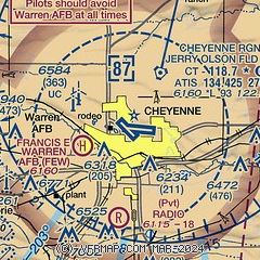
| Sectional chart |
|---|
|
CAUTION: Diagram may not be current
 Download PDF
of official airport diagram from the FAA
| Airport distance calculator |
|---|
|
|
| Sunrise and sunset |
|---|
|
Times for 23-Apr-2024
| | Local
(UTC-6) | | Zulu
(UTC) |
|---|
| Morning civil twilight | | 05:38 | | 11:38 |
| Sunrise | | 06:07 | | 12:07 |
| Sunset | | 19:47 | | 01:47 |
| Evening civil twilight | | 20:17 | | 02:17 |
|
| Current date and time |
|---|
| Zulu (UTC) | 23-Apr-2024 19:57:30 |
|---|
| Local (UTC-6) | 23-Apr-2024 13:57:30 |
|---|
|
| METAR |
|---|
| KCYS | 231953Z 15005G17KT 10SM CLR 12/M07 A3011 RMK AO2 SLP160 T01221067
|
KFEW
3nm SW | 231855Z AUTO 15009KT 10SM CLR 13/M09 A3012 RMK AO2 SLP167 T01251087 $
|
|
| TAF |
|---|
| KCYS | 231739Z 2318/2418 15011KT P6SM FEW250 FM232200 16011KT P6SM VCSH BKN080 FM240400 18015G21KT P6SM VCSH BKN060 FM241000 20010KT P6SM SCT100
|
|
| NOTAMs |
|---|
NOTAMs are issued by the DoD/FAA and will open in a separate window not controlled by AirNav.
|
|


