FAA INFORMATION EFFECTIVE 18 APRIL 2024
Location
| FAA Identifier: | DNS |
| Lat/Long: | 41-59-10.3166N 095-22-47.6671W
41-59.171943N 095-22.794452W
41.9861991,-95.3799075
(estimated) |
| Elevation: | 1274 ft. / 388.3 m (surveyed) |
| Variation: | 04E (2000) |
| From city: | 2 miles SW of DENISON, IA |
| Time zone: | UTC -5 (UTC -6 during Standard Time) |
| Zip code: | 51442 |
Airport Operations
| Airport use: | Open to the public |
| Activation date: | 05/1949 |
| Control tower: | no |
| ARTCC: | MINNEAPOLIS CENTER |
| FSS: | FORT DODGE FLIGHT SERVICE STATION |
| NOTAMs facility: | DNS (NOTAM-D service available) |
| Attendance: | MON - FRI 0800-1700
AFTER 1700 CALL 712-210-1900 |
| Wind indicator: | lighted |
| Segmented circle: | no |
| Lights: | MIRL RWY 12/30 PRESET ON LOW INTST; TO INCR INTST AND ACTVT PAPI RWYS 12 AND 30 AND REIL RWYS 12 AND 30 - CTAF. |
| Beacon: | white-green (lighted land airport)
Operates sunset to sunrise. |
Airport Communications
| CTAF/UNICOM: | 122.8 |
| WX AWOS-3: | 119.95 (712-263-6558) |
- APCH/DEP SVC PRVDD BY MINNEAPOLIS ARTCC ON FREQS 119.6/290.4 (OMAHA RCAG).
Airport Services
| Fuel available: | 100LL JET-A
100LL:FOR FUEL CALL AMGR 712-263-6424 OR (CELL) 712-210-1900. |
| Parking: | hangars and tiedowns |
| Airframe service: | NONE |
| Powerplant service: | NONE |
| Bottled oxygen: | NONE |
| Bulk oxygen: | NONE |
Runway Information
Runway 12/30
| Dimensions: | 5000 x 75 ft. / 1524 x 23 m |
| Surface: | concrete, in good condition |
| Weight bearing capacity: | | PCN 9 /R/C/W/T | | Single wheel: | 28.0 | | Double wheel: | 48.0 |
|
| Runway edge lights: | medium intensity |
| RUNWAY 12 | | RUNWAY 30 |
| Latitude: | 41-59.376798N | | 41-58.913108N |
| Longitude: | 095-23.226923W | | 095-22.315280W |
| Elevation: | 1273.9 ft. | | 1258.0 ft. |
| Traffic pattern: | left | | left |
| Runway heading: | 120 magnetic, 124 true | | 300 magnetic, 304 true |
| Markings: | nonprecision, in fair condition | | nonprecision, in fair condition |
| Visual slope indicator: | 2-light PAPI on left (3.00 degrees glide path) | | 2-light PAPI on left (3.00 degrees glide path) |
| Runway end identifier lights: | yes | | yes |
| Touchdown point: | yes, no lights | | yes, no lights |
| Obstructions: | none | | 10 ft. gnd, 399 ft. from runway, 244 ft. right of centerline, 20:1 slope to clear |
Runway 18/36
| Dimensions: | 2019 x 105 ft. / 615 x 32 m |
| Surface: | turf, in fair condition |
| Runway edge markings: | 18/36 THRS & SIDES MARKED WITH YELLOW CONES. |
| Operational restrictions: | CLSD NOV-APR. |
| RUNWAY 18 | | RUNWAY 36 |
| Latitude: | 41-59.404882N | | 41-59.072687N |
| Longitude: | 095-22.858712W | | 095-22.845838W |
| Elevation: | 1273.7 ft. | | 1256.4 ft. |
| Traffic pattern: | left | | left |
| Runway heading: | 174 magnetic, 178 true | | 354 magnetic, 358 true |
| Touchdown point: | yes, no lights | | yes, no lights |
Airport Ownership and Management from official FAA records
| Ownership: | Publicly-owned |
| Owner: | CITY OF DENISON
111 NORTH MAIN
DENISON, IA 51442
Phone 712-263-3143 |
| Manager: | RYAN LEED
2582 AIRPORT ST
DENISON, IA 51442
Phone 712-263-6424 |
Airport Operational Statistics
| Aircraft based on the field: | | 11 | | Single engine airplanes: | | 9 | | Multi engine airplanes: | | 2 |
| |  | |
| Aircraft operations: avg 53/week * | | 54% | transient general aviation | | 43% | local general aviation | | 2% | air taxi | | <1% | military | | * for 12-month period ending 02 September 2021 | |
Additional Remarks
| - | RY 30 IS CALM WIND RY. |
| - | CAUTION FOR WILDLIFE IN VICINITY |
| - | FOR CD IF UNA TO CTC ON FSS FREQ, CTC MINNEAPOLIS ARTCC AT 651-463-5588. |
Instrument Procedures
NOTE: All procedures below are presented as PDF files. If you need a reader for these files, you should download the free Adobe Reader.NOT FOR NAVIGATION. Please procure official charts for flight.
FAA instrument procedures published for use from 18 April 2024 at 0901Z to 16 May 2024 at 0900Z.
IAPs - Instrument Approach Procedures |
|---|
| RNAV (GPS) RWY 12 | |
download (253KB) |
| RNAV (GPS) RWY 30 | |
download (272KB) |
| NOTE: Special Alternate Minimums apply | |
download (123KB) |
| NOTE: Special Take-Off Minimums/Departure Procedures apply | |
download (437KB) |
Other nearby airports with instrument procedures:
KMEY - James G Whiting Memorial Field Airport (22 nm NW)
KHNR - Harlan Municipal Airport (24 nm S)
KCIN - Arthur N Neu Airport (27 nm E)
KADU - Audubon County Airport (27 nm SE)
KSKI - Sac City Municipal Airport (30 nm NE)
|
|

Road maps at:
MapQuest
Bing
Google
| Aerial photo |
|---|
WARNING: Photo may not be current or correct

Do you have a better or more recent aerial photo of Denison Municipal Airport that you would like to share? If so, please send us your photo.
|
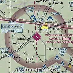
| Sectional chart |
|---|
|
| Airport distance calculator |
|---|
|
|
| Sunrise and sunset |
|---|
|
Times for 19-Apr-2024
| | Local
(UTC-5) | | Zulu
(UTC) |
|---|
| Morning civil twilight | | 06:05 | | 11:05 |
| Sunrise | | 06:34 | | 11:34 |
| Sunset | | 20:07 | | 01:07 |
| Evening civil twilight | | 20:36 | | 01:36 |
|
| Current date and time |
|---|
| Zulu (UTC) | 19-Apr-2024 13:44:37 |
|---|
| Local (UTC-5) | 19-Apr-2024 08:44:37 |
|---|
|
| METAR |
|---|
| KDNS | 191335Z AUTO 00000KT 10SM CLR 03/02 A3026 RMK AO2
|
|
| TAF |
|---|
KOMA
46nm SW | 191120Z 1912/2012 28007KT P6SM FEW240 FM191800 31012G21KT P6SM SCT250 FM200000 33008KT P6SM FEW240
|
|
| NOTAMs |
|---|
NOTAMs are issued by the DoD/FAA and will open in a separate window not controlled by AirNav.
|
|

