FAA INFORMATION EFFECTIVE 18 APRIL 2024
Location
| FAA Identifier: | ECS |
| Lat/Long: | 43-53-03.3000N 104-18-52.2000W
43-53.055000N 104-18.870000W
43.8842500,-104.3145000
(estimated) |
| Elevation: | 4177.5 ft. / 1273.3 m (surveyed) |
| Variation: | 08E (2015) |
| From city: | 5 miles NW of NEWCASTLE, WY |
| Time zone: | UTC -6 (UTC -7 during Standard Time) |
| Zip code: | 82701 |
Airport Operations
| Airport use: | Open to the public |
| Activation date: | 12/1938 |
| Control tower: | no |
| ARTCC: | DENVER CENTER |
| FSS: | CASPER FLIGHT SERVICE STATION |
| NOTAMs facility: | CPR (NOTAM-D service available) |
| Attendance: | MON-SAT 0800-1700
UNATNDD MAJOR HOLS - CALL AFT HRS ON THESE DAYS.
FOR ATTENDANT AFT HRS CALL 307-746-5805. |
| Wind indicator: | lighted |
| Segmented circle: | yes |
| Lights: | ACTVT ODALS RWY 32; REIL RWY 14; PAPI RWY 14 & 32; MIRL RWY 14/32 - CTAF. |
| Beacon: | white-green (lighted land airport)
Operates sunset to sunrise. |
Airport Communications
| CTAF/UNICOM: | 122.8 |
| WX AWOS-3PT: | 118.0 (307-746-4896) |
- APCH/DEP CTL SVC PRVDD BY DENVER ARTCC (ZDV) ON FREQS 127.95/338.2 (CRAWFORD RCAG).
Nearby radio navigation aids
| VOR radial/distance | | VOR name | | Freq | | Var |
|---|
| ECS at field | | NEWCASTLE VOR | | 108.20 | | 11E |
Airport Services
| Fuel available: | 100LL JET-A
100LL:FOR FUEL AFT HRS PHONE 307-746-5805. |
| Parking: | hangars and tiedowns |
| Airframe service: | NONE |
| Powerplant service: | NONE |
| Bottled oxygen: | NONE |
| Bulk oxygen: | NONE |
Runway Information
Runway 14/32
| Dimensions: | 5310 x 75 ft. / 1618 x 23 m |
| Surface: | asphalt, in good condition |
| Weight bearing capacity: | | PCN 13 /F/C/W/U | | Single wheel: | 30.0 |
|
| Runway edge lights: | medium intensity |
| RUNWAY 14 | | RUNWAY 32 |
| Latitude: | 43-53.407478N | | 43-52.701318N |
| Longitude: | 104-19.225750W | | 104-18.514123W |
| Elevation: | 4168.7 ft. | | 4177.5 ft. |
| Traffic pattern: | right | | left |
| Runway heading: | 136 magnetic, 144 true | | 316 magnetic, 324 true |
| Markings: | nonprecision, in good condition | | nonprecision, in good condition |
| Visual slope indicator: | 2-light PAPI on left (3.00 degrees glide path) | | 2-light PAPI on left (3.00 degrees glide path) |
| Approach lights: | | | ODALS: omnidirectional approach lighting system |
| Runway end identifier lights: | yes | | no |
| Touchdown point: | yes, no lights | | yes, no lights |
| Obstructions: | 38 ft. rr, 1184 ft. from runway, 125 ft. left of centerline, 27:1 slope to clear | | none |
Airport Ownership and Management from official FAA records
| Ownership: | Publicly-owned |
| Owner: | CITY OF NEWCASTLE/WESTON CO
COUNTY COURT HOUSE/1 W MAIN
NEWCASTLE, WY 82701
Phone 307-746-4744
PHONE NUMBER FOR CITY 307-746-3535 |
| Manager: | BYRAND STREETER
PO BOX 699
NEWCASTLE, WY 82701
Phone 307-746-4666 |
Airport Operational Statistics
| Aircraft based on the field: | | 14 | | Single engine airplanes: | | 14 |
| |  | |
| Aircraft operations: avg 100/week * | | 52% | transient general aviation | | 46% | local general aviation | | 2% | air taxi | | <1% | military | | * for 12-month period ending 30 June 2023 | |
Additional Remarks
| - | WILDLIFE ON OR NEAR THE RWYS. MIGRATORY BIRD FLT PATHS NEAR ARPT. |
| - | SOFT SHOULDERS NEAR EDGES OF RWYS, TWYS, & RAMPS. |
| - | FOR CD IF UNA TO CTC ON FSS FREQ, CTC DENVER ARTCC AT 303-651-4257. |
| - | HIGH VOL OF ACFT OPRNG INVOF OF MT RUSHMORE AND CRAZY HORSE MONUMENTS AT OR BLW 7500 FT; PILOTS ARE ADVISED TO MNT 122.85 FOR TFC ADVISORIES. |
Instrument Procedures
NOTE: All procedures below are presented as PDF files. If you need a reader for these files, you should download the free Adobe Reader.NOT FOR NAVIGATION. Please procure official charts for flight.
FAA instrument procedures published for use from 18 April 2024 at 0901Z to 16 May 2024 at 0900Z.
IAPs - Instrument Approach Procedures |
|---|
| RNAV (GPS) RWY 14 | |
download (221KB) |
| RNAV (GPS) RWY 32 | |
download (231KB) |
| VOR RWY 32 | |
download (195KB) |
| NOTE: Special Alternate Minimums apply | |
download (185KB) |
| NOTE: Special Take-Off Minimums/Departure Procedures apply | |
download (525KB) |
Other nearby airports with instrument procedures:
KSPF - Black Hills Airport-Clyde Ice Field (42 nm NE)
W43 - Hulett Municipal Airport (48 nm N)
KHSR - Hot Springs Municipal Airport (51 nm SE)
49B - Sturgis Municipal Airport (52 nm NE)
KRCA - Ellsworth Air Force Base (55 nm E)
|
|

Road maps at:
MapQuest
Bing
Google
| Aerial photo |
|---|
WARNING: Photo may not be current or correct
 Photo taken 29-Aug-2007
Do you have a better or more recent aerial photo of Mondell Field Airport that you would like to share? If so, please send us your photo.
|
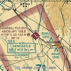
| Sectional chart |
|---|
|
| Airport distance calculator |
|---|
|
|
| Sunrise and sunset |
|---|
|
Times for 25-Apr-2024
| | Local
(UTC-6) | | Zulu
(UTC) |
|---|
| Morning civil twilight | | 05:26 | | 11:26 |
| Sunrise | | 05:57 | | 11:57 |
| Sunset | | 19:53 | | 01:53 |
| Evening civil twilight | | 20:24 | | 02:24 |
|
| Current date and time |
|---|
| Zulu (UTC) | 25-Apr-2024 14:44:25 |
|---|
| Local (UTC-6) | 25-Apr-2024 08:44:25 |
|---|
|
| METAR |
|---|
| KECS | 251435Z AUTO 15014G19KT 10SM BKN110 12/05 A2980 RMK AO2
|
|
| NOTAMs |
|---|
NOTAMs are issued by the DoD/FAA and will open in a separate window not controlled by AirNav.
|
|

