FAA INFORMATION EFFECTIVE 18 APRIL 2024
Location
| FAA Identifier: | FKS |
| Lat/Long: | 44-37-30.7260N 086-12-03.0790W
44-37.512100N 086-12.051317W
44.6252017,-86.2008553
(estimated) |
| Elevation: | 633.2 ft. / 193.0 m (surveyed) |
| Variation: | 04W (1985) |
| From city: | 2 miles SE of FRANKFORT, MI |
| Time zone: | UTC -4 (UTC -5 during Standard Time) |
| Zip code: | 49635 |
Airport Operations
| Airport use: | Open to the public |
| Activation date: | 04/1940 |
| Control tower: | no |
| ARTCC: | MINNEAPOLIS CENTER |
| FSS: | LANSING FLIGHT SERVICE STATION |
| NOTAMs facility: | FKS (NOTAM-D service available) |
| Attendance: | IREG
ON CALL ATTENDANT 231-352-9118. |
| Wind indicator: | lighted |
| Segmented circle: | yes |
| Lights: | ACTVT REIL RWY 33; PAPI RWY 33; MIRL RWY 15/33 - CTAF (3 MIKE CLICKS TURNS OFF). |
| Beacon: | white-green (lighted land airport)
ARPT BCN LOCATED ON HILL 1.25 MILES NW OF ARPT. Operates sunset to sunrise. |
Airport Communications
| CTAF/UNICOM: | 123.05 |
| WX AWOS-3P: | 118.325 (231-352-7573) |
- APCH/DEP SVC PRVDD BY MINNEAPOLIS ARTCC ON FREQS 132.9/338.3 (TRAVERSE CITY RCAG).
Nearby radio navigation aids
| VOR radial/distance | | VOR name | | Freq | | Var |
|---|
| TVCr267/27.9 | | TRAVERSE CITY VOR/DME | | 114.60 | | 02W |
Airport Services
| Fuel available: | 100LL
100LL:AVBL SELF SER VIA CREDIT CARD. |
| Parking: | hangars and tiedowns |
| Bottled oxygen: | NONE |
| Bulk oxygen: | NONE |
Runway Information
Runway 15/33
| Dimensions: | 4050 x 75 ft. / 1234 x 23 m |
| Surface: | asphalt, in good condition |
| Weight bearing capacity: | |
| Runway edge lights: | medium intensity |
| RUNWAY 15 | | RUNWAY 33 |
| Latitude: | 44-37.764933N | | 44-37.259267N |
| Longitude: | 086-12.355367W | | 086-11.747300W |
| Elevation: | 633.2 ft. | | 606.0 ft. |
| Traffic pattern: | left | | left |
| Runway heading: | 143 magnetic, 139 true | | 323 magnetic, 319 true |
| Displaced threshold: | 1094 ft. | | 111 ft. |
| Markings: | nonprecision, in good condition | | nonprecision, in good condition |
| Visual slope indicator: | | | 2-light PAPI on right (3.00 degrees glide path) |
| Runway end identifier lights: | no | | yes |
| Touchdown point: | yes, no lights | | yes, no lights |
| Obstructions: | 20 ft. road, 201 ft. from runway, 230 ft. left of centerline
+20 FT ROAD. | | 56 ft. tree, 636 ft. from runway, 328 ft. left of centerline, 7:1 slope to clear
APCH RATIO 18:1 TO DTHR. |
Airport Ownership and Management from official FAA records
| Ownership: | Publicly-owned |
| Owner: | FRANKFORT CITY-CO ARPT AUTH
650 AIRPORT RD
FRANKFORT, MI 49635-9785
Phone 231-651-0751 |
| Manager: | RICHARD BAYER
650 AIRPORT RD
FRANKFORT, MI 49635-9785
Phone 231-651-0751 |
Airport Operational Statistics
| Aircraft based on the field: | | 19 | | Single engine airplanes: | | 17 | | Helicopters: | | 1 | | Gliders airplanes: | | 1 |
| |  | |
| Aircraft operations: avg 77/week * | | 50% | transient general aviation | | 50% | local general aviation | | * for 12-month period ending 31 December 2020 | |
Additional Remarks
| - | UAS OPR WEST OF RWY 15/33. |
| - | ADMIN BLDG ACES, PRESS 5-3-2-1. |
| - | RAMP FEE FOR COML ACFT. |
| - | HANG GLIDER ACTIVITY ALONG LAKE MICHIGAN LAKESHORE. |
| - | FOR CD CTC MINNEAPOLIS ARTCC AT 651-463-5588. |
| - | DEER & BIRDS ON & INVOF ARPT. |
Instrument Procedures
NOTE: All procedures below are presented as PDF files. If you need a reader for these files, you should download the free Adobe Reader.NOT FOR NAVIGATION. Please procure official charts for flight.
FAA instrument procedures published for use from 18 April 2024 at 0901Z to 16 May 2024 at 0900Z.
IAPs - Instrument Approach Procedures |
|---|
| RNAV (GPS) RWY 15 **CHANGED** | |
download (224KB) |
| RNAV (GPS) RWY 33 **CHANGED** | |
download (212KB) |
| NOTE: Special Alternate Minimums apply | |
download (136KB) |
| NOTE: Special Take-Off Minimums/Departure Procedures apply | |
download (337KB) |
Other nearby airports with instrument procedures:
KMBL - Manistee County/Blacker Airport (21 nm S)
KTVC - Cherry Capital Airport (27 nm E)
KCAD - Wexford County Airport (40 nm SE)
KLDM - Mason County Airport (41 nm S)
7D3 - Baldwin Municipal Airport (48 nm S)
|
|

Road maps at:
MapQuest
Bing
Google
| Aerial photo |
|---|
WARNING: Photo may not be current or correct
 Taken in October 2006
Do you have a better or more recent aerial photo of Frankfort Dow Memorial Field that you would like to share? If so, please send us your photo.
|
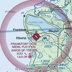
| Sectional chart |
|---|
|
| Airport distance calculator |
|---|
|
|
| Sunrise and sunset |
|---|
|
Times for 25-Apr-2024
| | Local
(UTC-4) | | Zulu
(UTC) |
|---|
| Morning civil twilight | | 06:12 | | 10:12 |
| Sunrise | | 06:43 | | 10:43 |
| Sunset | | 20:42 | | 00:42 |
| Evening civil twilight | | 21:13 | | 01:13 |
|
| Current date and time |
|---|
| Zulu (UTC) | 25-Apr-2024 15:22:57 |
|---|
| Local (UTC-4) | 25-Apr-2024 11:22:57 |
|---|
|
| METAR |
|---|
| KFKS | 251455Z AUTO 27003KT 10SM CLR 09/M05 A3038 RMK AO2 T00861047
|
|
| TAF |
|---|
KMBL
22nm S | 251121Z 2512/2612 13003KT P6SM SKC FM252000 30007KT P6SM SKC FM260200 VRB04KT P6SM SKC
|
|
| NOTAMs |
|---|
NOTAMs are issued by the DoD/FAA and will open in a separate window not controlled by AirNav.
|
|
