FAA INFORMATION EFFECTIVE 14 MAY 2026
Location
| FAA Identifier: | GZL |
| Lat/Long: | 35-17-17.4000N 095-05-38.0000W
35-17.290000N 095-05.633333W
35.2881667,-95.0938889
(estimated) |
| Elevation: | 599.9 ft. / 182.8 m (surveyed) |
| Variation: | 03E (2010) |
| From city: | 3 miles NE of STIGLER, OK |
| Time zone: | UTC -5 (UTC -6 during Standard Time) |
| Zip code: | 74462 |
Airport Operations
| Airport use: | Open to the public |
| Activation date: | 01/1977 |
| Control tower: | no |
| ARTCC: | FORT WORTH CENTER |
| FSS: | MC ALESTER FLIGHT SERVICE STATION |
| NOTAMs facility: | MLC (NOTAM-D service available) |
| Attendance: | UNATNDD |
| Wind indicator: | lighted |
| Segmented circle: | yes |
| Lights: | ACTVT MIRL RWY 17/35 - CTAF. PAPI RWY 17 & 35 ON CONSLY. |
| Beacon: | white-green (lighted land airport)
Operates sunset to sunrise. |
Airport Communications
| CTAF: | 122.9 |
| WX AWOS-3PT: | 118.575 (918-967-8982) |
| WX AWOS-3 at JSV (17 nm NE): | 118.475 (918-775-4136) |
- APCH/DEP CTL SVC PRVDD BY FORT WORTH ARTCC (ZFW) ON 132.2/338.35 (MC ALESTER RCAG).
Airport Services
| Fuel available: | 100LL
100LL:SELF SERVICE FUEL IS AVBL 24 HRS. |
| Parking: | tiedowns |
| Airframe service: | NONE |
| Powerplant service: | NONE |
| Bottled oxygen: | NONE |
| Bulk oxygen: | NONE |
Runway Information
Runway 17/35
| Dimensions: | 4296 x 60 ft. / 1309 x 18 m |
| Surface: | asphalt, in good condition |
| Weight bearing capacity: | |
| Runway edge lights: | medium intensity |
| RUNWAY 17 | | RUNWAY 35 |
| Latitude: | 35-17.643908N | | 35-16.935517N |
| Longitude: | 095-05.630718W | | 095-05.635208W |
| Elevation: | 599.6 ft. | | 599.8 ft. |
| Traffic pattern: | left | | left |
| Runway heading: | 177 magnetic, 180 true | | 357 magnetic, 000 true |
| Displaced threshold: | 95 ft. | | no |
| Declared distances: | TORA:4296 TODA:4296 ASDA:4296 LDA:4200 | | TORA:4296 TODA:4296 ASDA:4296 LDA:4296 |
| Markings: | nonprecision, in good condition | | nonprecision, in good condition |
| Visual slope indicator: | 2-light PAPI on left (2.75 degrees glide path) | | 2-light PAPI on left (3.00 degrees glide path) |
| Touchdown point: | yes, no lights | | yes, no lights |
| Obstructions: | 37 ft. pline, marked, 860 ft. from runway, 17:1 slope to clear | | 18 ft. tree, 526 ft. from runway, 74 ft. right of centerline, 18:1 slope to clear |
Airport Ownership and Management from official FAA records
| Ownership: | Publicly-owned |
| Owner: | CITY OF STIGLER
115 S. BROADWAY, 115 S. BDWY
STIGLER, OK 74462
Phone 918-967-2164 |
| Manager: | BOBBY MOUSER
CITY HALL, 115 S. BDWY
STIGLER, OK 74462
Phone 918-967-2164
CITY MANAGER. |
Additional Remarks
| - | FOR CD CTC FORT WORTH ARTCC AT 817-858-7584. |
| - | AFT HRS POLICE NON-EMER: 918-967-3377. |
Instrument Procedures
NOTE: All procedures below are presented as PDF files. If you need a reader for these files, you should download the free Adobe Reader.NOT FOR NAVIGATION. Please procure official charts for flight.
FAA instrument procedures published for use from 14 May 2026 at 0901Z to 11 June 2026 at 0900Z.
IAPs - Instrument Approach Procedures |
|---|
| RNAV (GPS) RWY 17 | |
download (214KB) |
| RNAV (GPS) RWY 35 | |
download (204KB) |
| NOTE: Special Alternate Minimums apply | |
download (108KB) |
| NOTE: Special Take-Off Minimums/Departure Procedures apply | |
download |
Other nearby airports with instrument procedures:
KJSV - Sallisaw Municipal Airport (17 nm NE)
KMKO - Muskogee-Davis Regional Airport (26 nm NW)
KRKR - Robert S Kerr Airport (28 nm SE)
KFSM - Fort Smith Regional Airport (36 nm E)
KTQH - Tahlequah Municipal Airport (39 nm N)
|
|

Road maps at:
MapQuest
Bing
Google
| Aerial photo |
|---|
WARNING: Photo may not be current or correct
 Photo by Brent Butler
Photo taken 15-Oct-2010
from the southeast.
Photo by Brent Butler
Photo taken 15-Oct-2010
from the southeast.
Do you have a better or more recent aerial photo of Stigler Regional Airport that you would like to share? If so, please send us your photo.
|
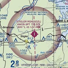
| Sectional chart |
|---|
|
| Airport distance calculator |
|---|
|
|
| Sunrise and sunset |
|---|
|
Times for 24-May-2026
| | Local
(UTC-5) | | Zulu
(UTC) |
|---|
| Morning civil twilight | | 05:42 | | 10:42 |
| Sunrise | | 06:11 | | 11:11 |
| Sunset | | 20:23 | | 01:23 |
| Evening civil twilight | | 20:52 | | 01:52 |
|
| Current date and time |
|---|
| Zulu (UTC) | 24-May-2026 15:59:39 |
|---|
| Local (UTC-5) | 24-May-2026 10:59:39 |
|---|
|
| METAR |
|---|
| KGZL | 241535Z AUTO 00000KT 10SM CLR 24/20 A3005 RMK AO2
|
KJSV
17nm NE | 241535Z AUTO 00000KT 6SM BR SCT018 24/23 A3007 RMK AO2
|
|
| TAF |
|---|
KFSM
36nm E | 241424Z 2414/2512 VRB04KT P6SM OVC013 FM241600 03004KT P6SM SCT025 FM241800 04007KT P6SM FEW040 FEW250
|
KMLC
42nm SW | 241425Z 2414/2512 VRB03KT 5SM BR OVC002 FM241600 03005KT P6SM FEW250
|
|
| NOTAMs |
|---|
NOTAMs are issued by the DoD/FAA and will open in a separate window not controlled by AirNav.
|
|

