FAA INFORMATION EFFECTIVE 18 APRIL 2024
Location
| FAA Identifier: | HVC |
| Lat/Long: | 36-51-25.1000N 087-27-18.3000W
36-51.418333N 087-27.305000W
36.8569722,-87.4550833
(estimated) |
| Elevation: | 563.5 ft. / 171.8 m (surveyed) |
| Variation: | 01W (1995) |
| From city: | 2 miles E of HOPKINSVILLE, KY |
| Time zone: | UTC -5 (UTC -6 during Standard Time) |
| Zip code: | 42240 |
Airport Operations
| Airport use: | Open to the public |
| Activation date: | 11/1952 |
| Control tower: | no |
| ARTCC: | MEMPHIS CENTER |
| FSS: | LOUISVILLE FLIGHT SERVICE STATION |
| NOTAMs facility: | LOU (NOTAM-D service available) |
| Attendance: | 0900-1700 |
| Wind indicator: | lighted |
| Segmented circle: | yes |
| Lights: | ACTVT REIL RWY 08 & 26; PAPI RWY 08 & 26; MIRL RWY 08/26 - CTAF |
| Beacon: | white-green (lighted land airport)
Operates sunset to sunrise. |
Airport Communications
| CTAF/UNICOM: | 122.8 |
| WX AWOS-3: | 132.575 (270-886-6311) |
| CAMPBELL APPROACH: | 118.1 |
| CAMPBELL DEPARTURE: | 118.1 |
| WX ASOS at CKV (14 nm S): | 134.575 (931-431-3045) |
| WX AWOS-3 at EOD (17 nm S): | PHONE 270-956-3100 |
Nearby radio navigation aids
| VOR radial/distance | | VOR name | | Freq | | Var |
|---|
| CKVr353/14.2 | | CLARKSVILLE VOR/DME | | 110.60 | | 01W |
| NDB name | | Hdg/Dist | | Freq | | Var | | ID |
|---|
| AIRBE | | 346/7.5 | | 273 | | 01W | | FK | ..-. -.- |
Airport Services
| Fuel available: | 100LL JET-A+ |
| Parking: | hangars and tiedowns |
| Airframe service: | MINOR |
| Powerplant service: | MINOR |
Runway Information
Runway 8/26
| Dimensions: | 5505 x 100 ft. / 1678 x 30 m |
| Surface: | asphalt, in good condition |
| Weight bearing capacity: | |
| Runway edge lights: | medium intensity |
| RUNWAY 8 | | RUNWAY 26 |
| Latitude: | 36-51.322128N | | 36-51.514057N |
| Longitude: | 087-27.856440W | | 087-26.753030W |
| Elevation: | 536.7 ft. | | 563.5 ft. |
| Traffic pattern: | left | | left |
| Runway heading: | 079 magnetic, 078 true | | 259 magnetic, 258 true |
| Markings: | nonprecision, in good condition | | nonprecision, in good condition |
| Visual slope indicator: | 4-light PAPI on left (3.50 degrees glide path) | | 4-light PAPI on left (4.00 degrees glide path) |
| Runway end identifier lights: | yes | | yes |
| Touchdown point: | yes, no lights | | yes, no lights |
| Instrument approach: | | | LOCALIZER |
| Obstructions: | 87 ft. trees, 863 ft. from runway, 344 ft. left of centerline, 7:1 slope to clear | | 61 ft. trees, 1682 ft. from runway, 393 ft. left of centerline, 24:1 slope to clear |
Airport Ownership and Management from official FAA records
| Ownership: | Publicly-owned |
| Owner: | CITY OF HOPKINSVILLE
300 MEMORIAL FIELD DRIVE
HOPKINSVILLE, KY 42240
Phone 270-887-4157
270-498-3566 |
| Manager: | WILLIAM OUTLAW
300 MEMORIAL FIELD DRIVE
HOPKINSVILLE, KY 42240
Phone 270-887-4157 |
Airport Operational Statistics
| Aircraft based on the field: | | 38 | | Single engine airplanes: | | 36 | | Multi engine airplanes: | | 1 | | Gliders airplanes: | | 1 |
| |  | |
| Aircraft operations: avg 112/day * | | 46% | local general aviation | | 32% | transient general aviation | | 15% | military | | 7% | air taxi | | * for 12-month period ending 05 November 2019 | |
Additional Remarks
| - | FOR CD CTC CAMPBELL APCH AT 270-798-6441. |
Instrument Procedures
NOTE: All procedures below are presented as PDF files. If you need a reader for these files, you should download the free Adobe Reader.NOT FOR NAVIGATION. Please procure official charts for flight.
FAA instrument procedures published for use from 18 April 2024 at 0901Z to 16 May 2024 at 0900Z.
IAPs - Instrument Approach Procedures |
|---|
| RNAV (GPS) RWY 08 | |
download (209KB) |
| RNAV (GPS) RWY 26 | |
download (250KB) |
| NOTE: Special Take-Off Minimums/Departure Procedures apply | |
download (373KB) |
Other nearby airports with instrument procedures:
KHOP - Campbell Army Airfield (Fort Campbell) (11 nm S)
KCKV - Outlaw Field Airport (14 nm S)
KEOD - Sabre Army Airfield (Fort Campbell) (17 nm S)
2M0 - Princeton-Caldwell County Airport (25 nm NW)
M21 - Muhlenberg County Airport (26 nm NE)
|
|

Road maps at:
MapQuest
Bing
Google
| Aerial photo |
|---|
WARNING: Photo may not be current or correct
 Photo by Bobby Hester - Hopkinsville, KY
Do you have a better or more recent aerial photo of Hopkinsville-Christian County Airport that you would like to share? If so, please send us your photo.
|
| Sectional chart |
|---|
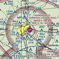
|
CAUTION: Diagram may not be current

| Airport distance calculator |
|---|
|
|
| Sunrise and sunset |
|---|
|
Times for 23-Apr-2024
| | Local
(UTC-5) | | Zulu
(UTC) |
|---|
| Morning civil twilight | | 05:38 | | 10:38 |
| Sunrise | | 06:05 | | 11:05 |
| Sunset | | 19:31 | | 00:31 |
| Evening civil twilight | | 19:58 | | 00:58 |
|
| Current date and time |
|---|
| Zulu (UTC) | 23-Apr-2024 14:39:18 |
|---|
| Local (UTC-5) | 23-Apr-2024 09:39:18 |
|---|
|
| METAR |
|---|
| KHVC | 231415Z AUTO 19011KT 10SM CLR 16/04 A3009 RMK AO2
|
KHOP
12nm S | 231355Z AUTO 19008KT 10SM CLR 15/04 A3010 RMK AO2 SLP194 T01450036 $
|
KCKV
15nm S | 231352Z AUTO 21006KT 10SM CLR 14/04 A3012 RMK AO2 SLP199 T01440039
|
KEOD
17nm S | 231355Z AUTO 22006KT 10SM CLR 14/05 A3014 RMK AO2 SLP209 T01410049
|
|
| TAF |
|---|
KHOP
12nm S | 230800Z 2308/2414 22005KT 9999 FEW200 QNH3011INS BECMG 2314/2315 23012G18KT 9999 FEW200 QNH3004INS BECMG 2318/2319 22015G25KT 9999 SCT080 QNH3000INS BECMG 2404/2405 23009KT 8000 -SHRA OVC030 540105 QNH3003INS BECMG 2408/2409 26005KT 8000 BR BKN005 OVC080 510105 QNH3005INS TEMPO 2409/2413 30005KT 4800 BR OVC005 TX21/2320Z TN07/2309Z
|
KCKV
15nm S | 231129Z 2312/2412 18003KT P6SM SCT250 FM231300 21010KT P6SM FEW250 FM231600 22016G24KT P6SM SCT250 FM240000 22012KT P6SM FEW120 FM240400 25008KT P6SM -SHRA OVC050
|
|
| NOTAMs |
|---|
NOTAMs are issued by the DoD/FAA and will open in a separate window not controlled by AirNav.
|
|

