FAA INFORMATION EFFECTIVE 18 APRIL 2024
Location
| FAA Identifier: | LNA |
| Lat/Long: | 26-35-35.0000N 080-05-06.2326W
26-35.583333N 080-05.103877W
26.5930556,-80.0850646
(estimated) |
| Elevation: | 14.2 ft. / 4.3 m (surveyed) |
| Variation: | 07W (2020) |
| From city: | 6 miles S of WEST PALM BEACH, FL |
| Time zone: | UTC -4 (UTC -5 during Standard Time) |
| Zip code: | 33462 |
Airport Operations
| Airport use: | Open to the public |
| Activation date: | 02/1943 |
| Control tower: | no |
| ARTCC: | MIAMI CENTER |
| FSS: | MIAMI FLIGHT SERVICE STATION |
| NOTAMs facility: | MIA (NOTAM-D service available) |
| Attendance: | 0800-1830 |
| Pattern altitude: | STANDARD PATTERN ENTRY TO ALL RUNWAYS STRONGLY RECOMMENDED. |
| Wind indicator: | lighted |
| Segmented circle: | yes |
| Lights: | DUSK-2000. AFTER 2000, ACTVT MIRL RWYS 04/22, 10/28 & 16/34 - CTAF. PAPI RWY 10, 16, 28, & 34 OPR CONSLY. |
| Beacon: | white-green (lighted land airport)
Operates sunset to sunrise. |
Airport Communications
| CTAF/UNICOM: | 122.7 |
| WX AWOS-3PT: | 119.925 (561-964-0308) |
| PALM BEACH APPROACH: | 127.35 |
| PALM BEACH DEPARTURE: | 127.35 |
| CLEARANCE DELIVERY: | 127.35 |
| JESTR STAR: | 124.6 |
| MELBOURNE STAR: | 124.6 |
| TTYLR STAR: | 125.2 |
| WX ASOS at PBI (5 nm N): | 123.75 (561-683-2548) |
| WX AWOS-3 at BCT (13 nm S): | 121.125 (561-391-2696) |
| WX AWOS-3 at F45 (17 nm NW): | 119.975 (561-630-6932) |
Nearby radio navigation aids
| VOR radial/distance | | VOR name | | Freq | | Var |
|---|
| PBIr182/5.2 | | PALM BEACH VORTAC | | 115.70 | | 03W |
| FLLr014/31.5 | | FORT LAUDERDALE VOR/DME | | 114.40 | | 06W |
| PHKr109/34.4 | | PAHOKEE VOR/DME | | 115.40 | | 00E |
| NDB name | | Hdg/Dist | | Freq | | Var | | ID |
|---|
| UNITED | | 150/23.2 | | 405 | | 05W | | UTX | ..- - -..- |
Airport Services
| Fuel available: | 100LL JET-A |
| Parking: | hangars and tiedowns |
| Airframe service: | MAJOR |
| Powerplant service: | MAJOR |
| Bottled oxygen: | NONE |
| Bulk oxygen: | NONE |
Runway Information
Runway 10/28
| Dimensions: | 3489 x 75 ft. / 1063 x 23 m |
| Surface: | asphalt, in good condition |
| Weight bearing capacity: | | PCN 10 /F/A/Y/T | | Single wheel: | 30.0 |
|
| Runway edge lights: | medium intensity |
| RUNWAY 10 | | RUNWAY 28 |
| Latitude: | 26-35.478892N | | 26-35.459170N |
| Longitude: | 080-05.458462W | | 080-04.818322W |
| Elevation: | 12.4 ft. | | 12.7 ft. |
| Traffic pattern: | left | | left |
| Runway heading: | 099 magnetic, 092 true | | 279 magnetic, 272 true |
| Markings: | basic, in fair condition | | basic, in fair condition |
| Visual slope indicator: | 2-light PAPI on left (4.00 degrees glide path) | | 2-light PAPI on left (4.00 degrees glide path) |
| Touchdown point: | yes, no lights | | yes, no lights |
| Obstructions: | 42 ft. trees, 1045 ft. from runway, 125 ft. right of centerline, 20:1 slope to clear
RWY 28 APCH SLP 23:1 TO AER. | | 11 ft. brush, 370 ft. from runway, 50 ft. left of centerline, 15:1 slope to clear |
Runway 16/34
| Dimensions: | 3421 x 100 ft. / 1043 x 30 m |
| Surface: | asphalt, in fair condition |
| Weight bearing capacity: | | PCN 15 /F/A/X/T | | Single wheel: | 30.0 |
|
| Runway edge lights: | medium intensity |
| RUNWAY 16 | | RUNWAY 34 |
| Latitude: | 26-35.898175N | | 26-35.399708N |
| Longitude: | 080-05.123988W | | 080-04.828817W |
| Elevation: | 13.7 ft. | | 13.1 ft. |
| Traffic pattern: | left | | left |
| Runway heading: | 159 magnetic, 152 true | | 339 magnetic, 332 true |
| Markings: | nonprecision, in fair condition | | nonprecision, in fair condition |
| Visual slope indicator: | 2-light PAPI on left (3.50 degrees glide path) | | 2-light PAPI on left (3.50 degrees glide path) |
| Touchdown point: | yes, no lights | | yes, no lights |
| Obstructions: | 17 ft. trees, 600 ft. from runway, 30 ft. right of centerline, 23:1 slope to clear
RWY 34 APCH SLP 25:1 TO AER. | | 5 ft. brush, 200 ft. from runway, 150 ft. right of centerline, 1:1 slope to clear
RWY 34 HAS 5 FT BRUSH 200 FT FM RWY END 150 FT RIGHT. |
Runway 4/22
| Dimensions: | 3256 x 75 ft. / 992 x 23 m |
| Surface: | asphalt, in fair condition |
| Weight bearing capacity: | | PCN 8 /F/A/Y/T | | Single wheel: | 30.0 |
|
| Runway edge lights: | medium intensity |
| RUNWAY 4 | | RUNWAY 22 |
| Latitude: | 26-35.407077N | | 26-35.862982N |
| Longitude: | 080-05.359103W | | 080-05.042543W |
| Elevation: | 12.5 ft. | | 13.7 ft. |
| Traffic pattern: | left | | left |
| Runway heading: | 039 magnetic, 032 true | | 219 magnetic, 212 true |
| Markings: | basic, in fair condition | | basic, in fair condition |
| Visual slope indicator: | 2-light PAPI on left (3.00 degrees glide path) | | 2-light PAPI on left (3.00 degrees glide path) |
| Touchdown point: | yes, no lights | | yes, no lights |
| Obstructions: | 37 ft. tree, 970 ft. from runway, 21:1 slope to clear | | 16 ft. brush, 525 ft. from runway, 70 ft. left of centerline, 21:1 slope to clear |
Airport Ownership and Management from official FAA records
| Ownership: | Publicly-owned |
| Owner: | PALM BEACH COUNTY
DEPARTMENT OF AIRPORTS, 846 PBIA
WEST PALM BEACH, FL 33406-1491
Phone 561-471-7420 |
| Manager: | LAURA BEEBE
846 PALM BEACH INTL AIRPORT
WEST PALM BEACH, FL 33406-1470
Phone (561) 471-7420 |
Airport Operational Statistics
| Aircraft based on the field: | | 218 | | Single engine airplanes: | | 163 | | Multi engine airplanes: | | 41 | | Jet airplanes: | | 2 | | Helicopters: | | 12 |
| |  | |
| Aircraft operations: avg 282/day * | | 70% | local general aviation | | 28% | transient general aviation | | 2% | air taxi | | <1% | military | | * for 12-month period ending 31 December 2018 | |
Additional Remarks
| - | RWY 34 APCH END HAS 25 FT BLDG 50 FT FM RWY END 225 FT LEFT OF EXTDD CTLN. |
| - | LNA IS A NOISE-SENSITIVE ARPT; USE OF THE PREF NOISE ABATEMENT RWY, RWY 4-22, CONDS PMTG, IS STGLY ENCOURAGED. CALL (561)471-7468 |
| - | NO TGLS ON RY 10/28. |
| - | HELICOPTERS USE RIGHT TRAFFIC TO ALL RYS. |
| - | EXTENSIVE FLIGHT TRAINING, MULTIPLE RUNWAYS IN USE. |
| - | NONSTANDARD HOLD SHORT MARKINGS ON TWY P BTN RWYS 10/28 AND 16/34. |
| - | AIRPORT SURFACE CONDITIONS NOT REPORTED FOR ALL RUNWAYS. |
| - | FOR CD CTC PALM BEACH APCH AT 561-684-9047. |
Instrument Procedures
NOTE: All procedures below are presented as PDF files. If you need a reader for these files, you should download the free Adobe Reader.NOT FOR NAVIGATION. Please procure official charts for flight.
FAA instrument procedures published for use from 18 April 2024 at 0901Z to 16 May 2024 at 0900Z.
STARs - Standard Terminal Arrivals |
|---|
| JESTR ONE (RNAV) | |
2 pages:
[1] [2] (273KB) |
| MELBOURNE TWO **CHANGED** | |
download (119KB) |
| TTYLR THREE **CHANGED** | |
download (205KB) |
IAPs - Instrument Approach Procedures |
|---|
| RNAV (GPS) RWY 34 | |
download (232KB) |
| RNAV (GPS)-A | |
download (216KB) |
| RNAV (GPS)-B | |
download (216KB) |
| NOTE: Special Take-Off Minimums/Departure Procedures apply | |
download (257KB) |
Other nearby airports with instrument procedures:
KPBI - Palm Beach International Airport (5 nm N)
KBCT - Boca Raton Airport (13 nm S)
F45 - North Palm Beach County General Aviation Airport (17 nm NW)
KPMP - Pompano Beach Airpark (21 nm S)
06FA - William P Gwinn Airport (23 nm NW)
|
|

Road maps at:
MapQuest
Bing
Google
| Aerial photo |
|---|
WARNING: Photo may not be current or correct
 Photo by Dave Fogarty ATP/CFI/A&P-IA
Photo taken 21-Oct-2018
from 2,500 looking southwest.
Photo by Dave Fogarty ATP/CFI/A&P-IA
Photo taken 21-Oct-2018
from 2,500 looking southwest.
Do you have a better or more recent aerial photo of Palm Beach County Park Airport that you would like to share? If so, please send us your photo.
|
| Sectional chart |
|---|
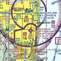
|
| Airport distance calculator |
|---|
|
|
| Sunrise and sunset |
|---|
|
Times for 19-Apr-2024
| | Local
(UTC-4) | | Zulu
(UTC) |
|---|
| Morning civil twilight | | 06:29 | | 10:29 |
| Sunrise | | 06:53 | | 10:53 |
| Sunset | | 19:46 | | 23:46 |
| Evening civil twilight | | 20:10 | | 00:10 |
|
| Current date and time |
|---|
| Zulu (UTC) | 19-Apr-2024 10:19:40 |
|---|
| Local (UTC-4) | 19-Apr-2024 06:19:40 |
|---|
|
| METAR |
|---|
| KLNA | 190955Z AUTO 00000KT 10SM CLR 21/21 A3005 RMK AO2 T02110211 TSNO
|
KPBI
5nm N | 190953Z 00000KT 10SM SCT250 21/19 A3005 RMK AO2 SLP174 T02060189
|
KBCT
13nm S | 190153Z 14010KT 10SM SCT030 24/19 A3006
|
KF45
17nm NW | 190955Z AUTO 00000KT 4SM BR BKN030 OVC037 18/18 A3004 RMK AO2 TSNO
|
|
| TAF |
|---|
KPBI
5nm N | 190522Z 1906/2006 VRB04KT P6SM SCT030 BKN250 FM191400 12010KT P6SM FEW030 SCT050 SCT250 FM200000 16008KT P6SM FEW030 SCT050 SCT250
|
|
| NOTAMs |
|---|
NOTAMs are issued by the DoD/FAA and will open in a separate window not controlled by AirNav.
|
|

