FAA INFORMATION EFFECTIVE 21 MARCH 2024
Location
| FAA Identifier: | MBL |
| Lat/Long: | 44-16-20.8740N 086-14-48.8430W
44-16.347900N 086-14.814050W
44.2724650,-86.2469008
(estimated) |
| Elevation: | 621.4 ft. / 189.4 m (surveyed) |
| Variation: | 06W (2015) |
| From city: | 3 miles NE of MANISTEE, MI |
| Time zone: | UTC -4 (UTC -5 during Standard Time) |
| Zip code: | 49660 |
Airport Operations
| Airport use: | Open to the public |
| Activation date: | 04/1940 |
| Control tower: | no |
| ARTCC: | MINNEAPOLIS CENTER |
| FSS: | LANSING FLIGHT SERVICE STATION |
| NOTAMs facility: | MBL (NOTAM-D service available) |
| Attendance: | NOV-MAR 0800-1700, JUN-AUG 0800-2000, APR & OCT 0800-1800, MAY & SEPT 0800-1900 |
| Wind indicator: | lighted |
| Segmented circle: | yes |
| Lights: | ACTVT MALSR RWY 28; REIL RWY 10; PAPI RWY 01, 19, 10, & 28; HIRL RWY 10/28; MIRL RWY 01/19 - CTAF. |
| Beacon: | white-green (lighted land airport)
Operates sunset to sunrise. |
| Fire and rescue: | ARFF index A |
| Airline operations: | CLSD TO SKED ACR OPS GTR THAN 9 PAX SEATS. 24 HR PPR FOR UNSKED ACR OPS GTR THAN 30 PAX SEATS - CALL AMGR. ARFF UNAVBL EXC ACR & PPR. |
Airport Communications
| CTAF/UNICOM: | 122.8 |
| WX AWOS-3PT: | 118.825 (231-723-6073) |
| WX AWOS-3 at LDM (20 nm S): | 119.925 (231-843-0459) |
- APCH/DEP SVC PRVDD BY MINNEAPOLIS ARTCC (ZMP) ON FREQS 120.85/322.35 (WHITE CLOUD RCAG).
Nearby radio navigation aids
| VOR radial/distance | | VOR name | | Freq | | Var |
|---|
| TVCr234/38.1 | | TRAVERSE CITY VOR/DME | | 114.60 | | 02W |
| NDB name | | Hdg/Dist | | Freq | | Var | | ID |
|---|
| JEPOT | | 277/4.5 | | 254 | | 06W | | MB | -- -... |
Airport Services
| Fuel available: | 100LL JET-A |
| Parking: | hangars and tiedowns |
| Airframe service: | MINOR |
| Powerplant service: | MINOR |
Runway Information
Runway 10/28
| Dimensions: | 5501 x 100 ft. / 1677 x 30 m |
| Surface: | asphalt/porous friction courses, in excellent condition |
| Weight bearing capacity: | | PCN 30 /F/A/X/T | | Single wheel: | 83.0 | | Double wheel: | 126.0 |
|
| Runway edge lights: | high intensity |
| RUNWAY 10 | | RUNWAY 28 |
| Latitude: | 44-16.369272N | | 44-16.346695N |
| Longitude: | 086-15.290033W | | 086-14.030402W |
| Elevation: | 617.6 ft. | | 621.3 ft. |
| Traffic pattern: | left | | left |
| Runway heading: | 097 magnetic, 091 true | | 277 magnetic, 271 true |
| Declared distances: | TORA:5501 TODA:5501 ASDA:5501 LDA:5501 | | TORA:5501 TODA:5501 ASDA:5501 LDA:5501 |
| Markings: | precision, in good condition | | precision, in good condition |
| Visual slope indicator: | 4-light PAPI on left (3.00 degrees glide path) | | 4-light PAPI on left (3.00 degrees glide path) |
| Approach lights: | | | MALSR: 1,400 foot medium intensity approach lighting system with runway alignment indicator lights |
| Runway end identifier lights: | yes | | no |
| Touchdown point: | yes, no lights | | yes, no lights |
| Instrument approach: | | | ILS |
| Obstructions: | 55 ft. tree, 2050 ft. from runway, 100 ft. left of centerline, 33:1 slope to clear | | 102 ft. trees, 4350 ft. from runway, 950 ft. left of centerline, 40:1 slope to clear |
Runway 1/19
| Dimensions: | 2721 x 75 ft. / 829 x 23 m |
| Surface: | asphalt, in good condition |
| Weight bearing capacity: | | PCN 6 /F/A/X/T | | Single wheel: | 25.5 |
|
| Runway edge lights: | medium intensity |
| Operational restrictions: | CLSD TO UNSKED ACR OPS GTR THAN 30 PAX SEATS EXC TAXI. |
| RUNWAY 1 | | RUNWAY 19 |
| Latitude: | 44-16.103613N | | 44-16.551253N |
| Longitude: | 086-15.132828W | | 086-15.117313W |
| Elevation: | 618.5 ft. | | 617.7 ft. |
| Traffic pattern: | left | | left |
| Runway heading: | 007 magnetic, 001 true | | 187 magnetic, 181 true |
| Declared distances: | TORA:2721 TODA:2721 ASDA:2721 LDA:2721 | | TORA:2721 TODA:2721 ASDA:2721 LDA:2721 |
| Markings: | basic, in good condition | | basic, in good condition |
| Visual slope indicator: | 2-light PAPI on left (4.00 degrees glide path) | | 2-light PAPI on left (4.00 degrees glide path) |
| Runway end identifier lights: | no | | no |
| Touchdown point: | yes, no lights | | yes, no lights |
| Obstructions: | 8 ft. tree, 312 ft. from runway, 75 ft. left of centerline, 14:1 slope to clear | | 49 ft. trees, 1080 ft. from runway, 172 ft. left of centerline, 17:1 slope to clear
ALSO +15 FT ROAD, 498 FT DIST, APCH RATIO 33:1. |
Airport Ownership and Management from official FAA records
| Ownership: | Publicly-owned |
| Owner: | MANISTEE BLACKER ARPT AUTHORITY
2323 AIRPORT RD
MANISTEE, MI 49660-9710
Phone 231-723-4351 |
| Manager: | BARRY LIND
2323 AIRPORT RD
MANISTEE, MI 49660-9710
Phone 231-723-4351 |
Airport Operational Statistics
| Aircraft based on the field: | | 6 | | Single engine airplanes: | | 6 |
| |  | |
| Aircraft operations: avg 131/week * | | 37% | local general aviation | | 34% | commercial | | 22% | transient general aviation | | 7% | air taxi | | 1% | military | | * for 12-month period ending 25 May 2023 | |
Additional Remarks
| - | BIRDS ON & INVOF ARPT. |
| - | FLD CONDS UNMON AFT ATNDD HRS EXC FOR ACR OPS. |
| - | TWY E MKD WITH REFLECTORS. |
| - | ARFF MNT CTAF DRG ACR OPS. |
| - | MAINT PSNL MNT CTAF DRG WORK ON TWYS & RWYS. |
Instrument Procedures
NOTE: All procedures below are presented as PDF files. If you need a reader for these files, you should download the free Adobe Reader.NOT FOR NAVIGATION. Please procure official charts for flight.
FAA instrument procedures published for use from 21 March 2024 at 0901Z to 18 April 2024 at 0900z.
IAPs - Instrument Approach Procedures |
|---|
| ILS OR LOC RWY 28 | |
download (269KB) |
| RNAV (GPS) RWY 10 | |
download (225KB) |
| RNAV (GPS) RWY 28 | |
download (221KB) |
| NOTE: Special Alternate Minimums apply | |
download (134KB) |
| NOTE: Special Take-Off Minimums/Departure Procedures apply | |
download (360KB) |
Other nearby airports with instrument procedures:
KLDM - Mason County Airport (20 nm S)
KFKS - Frankfort Dow Memorial Field (21 nm N)
7D3 - Baldwin Municipal Airport (30 nm SE)
KCAD - Wexford County Airport (36 nm E)
C04 - Oceana County Airport (38 nm S)
|
|

Road maps at:
MapQuest
Bing
Google
| Aerial photo |
|---|
WARNING: Photo may not be current or correct

Do you have a better or more recent aerial photo of Manistee County/Blacker Airport that you would like to share? If so, please send us your photo.
|
| Sectional chart |
|---|
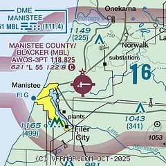
|
| Airport distance calculator |
|---|
|
|
| Sunrise and sunset |
|---|
|
Times for 18-Apr-2024
| | Local
(UTC-4) | | Zulu
(UTC) |
|---|
| Morning civil twilight | | 06:25 | | 10:25 |
| Sunrise | | 06:56 | | 10:56 |
| Sunset | | 20:33 | | 00:33 |
| Evening civil twilight | | 21:03 | | 01:03 |
|
| Current date and time |
|---|
| Zulu (UTC) | 18-Apr-2024 07:35:08 |
|---|
| Local (UTC-4) | 18-Apr-2024 03:35:08 |
|---|
|
| METAR |
|---|
| KMBL | 180612Z AUTO 27014G22KT 10SM SCT024 BKN035 OVC045 08/06 A2987 RMK AO2
|
KLDM
19nm S | 180615Z AUTO 27006KT 10SM BKN029 OVC048 08/04 A2989 RMK AO2 T00750040
|
|
| TAF |
|---|
| KMBL | 180520Z 1806/1906 27011G20KT P6SM VCSH OVC015 FM180900 29011G20KT P6SM OVC025 FM181500 28008KT P6SM VCSH OVC035 FM190000 VRB03KT P6SM VCSH SCT025 OVC040
|
|
| NOTAMs |
|---|
NOTAMs are issued by the DoD/FAA and will open in a separate window not controlled by AirNav.
|
|

