FAA INFORMATION EFFECTIVE 18 APRIL 2024
Location
| FAA Identifier: | MBS |
| Lat/Long: | 43-31-58.5370N 084-04-46.6890W
43-31.975617N 084-04.778150W
43.5329269,-84.0796358
(estimated) |
| Elevation: | 668.2 ft. / 203.7 m (surveyed) |
| Variation: | 07W (2020) |
| From city: | 9 miles NW of SAGINAW, MI |
| Time zone: | UTC -4 (UTC -5 during Standard Time) |
| Zip code: | 48623 |
Airport Operations
| Airport use: | Open to the public |
| Activation date: | 03/1943 |
| Control tower: | yes |
| ARTCC: | CLEVELAND CENTER |
| FSS: | LANSING FLIGHT SERVICE STATION |
| NOTAMs facility: | MBS (NOTAM-D service available) |
| Attendance: | CONTINUOUS
FOR SVC AFT HRS CALL 800-227-7907. |
| Wind indicator: | lighted |
| Segmented circle: | yes |
| Lights: | WHEN ATCT CLSD ACTVT MALSR RWY 05 & 23; REIL RWY 14 & 32; HIRL RWY 05/23 & 14/32 - CTAF. PAPI RWY 14, 23, & 32 OPR CONSLY. |
| Beacon: | white-green (lighted land airport)
Operates sunset to sunrise. |
| Landing fee: | yes, WAIVED WITH FUEL PURCHASE. |
| Fire and rescue: | ARFF index B |
| Airline operations: | INDEX C ARFF SVC AVBL UPON REQ. |
| International operations: | customs landing rights airport |
Airport Communications
| CTAF: | 120.1 |
| UNICOM: | 122.95 |
| ATIS: | 125.925 |
| WX ASOS: | PHONE 989-695-2488 |
| SAGINAW GROUND: | 121.7 [0600-2300] |
| SAGINAW TOWER: | 120.1 257.7 [0600-2300] |
| GREAT LAKES APPROACH: | 126.45 |
| GREAT LAKES DEPARTURE: | 126.45 |
| CLEARANCE DELIVERY: | 121.85 |
| TRSA: | 126.45 |
| WX AWOS-3 at IKW (11 nm NW): | 119.525 (989-835-5841) |
| WX AWOS-3PT at HYX (11 nm SE): | 118.325 (989-752-3408) |
- APCH/DEP SVC PRVDD BY CLEVELAND ARTCC (ZOB) ON FREQS 127.7/290.425 (FREELAND RCAG) WHEN GREAT LAKES APCH CTL CLSD.
Nearby radio navigation aids
| VOR radial/distance | | VOR name | | Freq | | Var |
|---|
| MBS at field | | SAGINAW VOR/DME | | 112.90 | | 03W |
| MOPr106/29.1 | | MOUNT PLEASANT VOR/DME | | 110.60 | | 05W |
| FNTr343/36.9 | | FLINT VORTAC | | 116.90 | | 06W |
| NDB name | | Hdg/Dist | | Freq | | Var | | ID |
|---|
| OLSTE | | 052/6.1 | | 257 | | 07W | | MB | -- -... |
Airport Services
| Fuel available: | 100LL JET-A |
| Parking: | hangars and tiedowns |
| Airframe service: | MINOR |
| Powerplant service: | MINOR |
| Bottled oxygen: | HIGH |
Runway Information
Runway 5/23
| Dimensions: | 8002 x 150 ft. / 2439 x 46 m |
| Surface: | asphalt/grooved, in good condition |
| Weight bearing capacity: | | PCN 50 /F/C/X/U | | Single wheel: | 135.0 | | Double wheel: | 160.0 | | Double tandem: | 265.0 |
|
| Runway edge lights: | high intensity |
| RUNWAY 5 | | RUNWAY 23 |
| Latitude: | 43-31.609255N | | 43-32.530472N |
| Longitude: | 084-05.354647W | | 084-04.060692W |
| Elevation: | 665.1 ft. | | 649.2 ft. |
| Traffic pattern: | left | | left |
| Runway heading: | 053 magnetic, 046 true | | 233 magnetic, 226 true |
| Declared distances: | TORA:8002 TODA:8002 ASDA:8002 LDA:8002 | | TORA:8002 TODA:8002 ASDA:8002 LDA:8002 |
| Markings: | precision, in good condition | | precision, in good condition |
| Visual slope indicator: | | | 4-light PAPI on left (3.00 degrees glide path) |
| RVR equipment: | touchdown, rollout | | touchdown, rollout |
| Approach lights: | MALSR: 1,400 foot medium intensity approach lighting system with runway alignment indicator lights | | MALSR: 1,400 foot medium intensity approach lighting system with runway alignment indicator lights |
| Runway end identifier lights: | no | | no |
| Touchdown point: | yes, no lights | | yes, no lights |
| Instrument approach: | ILS | | ILS/DME |
Runway 14/32
| Dimensions: | 6399 x 150 ft. / 1950 x 46 m |
| Surface: | asphalt/grooved, in fair condition |
| Weight bearing capacity: | | PCN 50 /F/C/X/U | | Single wheel: | 135.0 | | Double wheel: | 160.0 | | Double tandem: | 265.0 |
|
| Runway edge lights: | high intensity |
| RUNWAY 14 | | RUNWAY 32 |
| Latitude: | 43-32.234153N | | 43-31.481282N |
| Longitude: | 084-05.372487W | | 084-04.359960W |
| Elevation: | 667.8 ft. | | 659.2 ft. |
| Traffic pattern: | left | | left |
| Runway heading: | 143 magnetic, 136 true | | 323 magnetic, 316 true |
| Declared distances: | TORA:6399 TODA:6399 ASDA:6399 LDA:6399 | | TORA:6399 TODA:6399 ASDA:6399 LDA:6399 |
| Markings: | nonprecision, in good condition | | nonprecision, in good condition |
| Visual slope indicator: | 4-light PAPI on left (3.00 degrees glide path) | | 4-light PAPI on left (3.00 degrees glide path) |
| Runway end identifier lights: | yes | | yes |
| Touchdown point: | yes, no lights | | yes, no lights |
| Obstructions: | 55 ft. trees, 2300 ft. from runway, 100 ft. right of centerline, 38:1 slope to clear | | 56 ft. trees, 2500 ft. from runway, 120 ft. left of centerline, 41:1 slope to clear |
Airport Ownership and Management from official FAA records
| Ownership: | Publicly-owned |
| Owner: | MBS INTERNATIONAL
8500 GARFIELD RD STE 101
FREELAND, MI 48623-8626
Phone 989-695-5555 |
| Manager: | JAMES CANDERS
8500 GARFIELD RD STE 101
FREELAND, MI 48623-8626
Phone 989-695-5555
AFT BUS HRS CALL 989-695-5558. |
Airport Operational Statistics
| Aircraft based on the field: | | 18 | | Single engine airplanes: | | 7 | | Multi engine airplanes: | | 6 | | Jet airplanes: | | 5 |
| |  | |
| Aircraft operations: avg 46/day * | | 51% | transient general aviation | | 22% | air taxi | | 22% | local general aviation | | 2% | military | | 2% | commercial | | * for 12-month period ending 31 December 2022 | |
Additional Remarks
| - | BIRDS ON & INVOF ARPT. |
| - | FOR CD WHEN ATCT CLSD CTC GREAT LAKES APCH AT 269-459-3345, WHEN APCH CLSD CTC CLEVELAND ARTCC AT 440-774-0224/0490. |
Instrument Procedures
NOTE: All procedures below are presented as PDF files. If you need a reader for these files, you should download the free Adobe Reader.NOT FOR NAVIGATION. Please procure official charts for flight.
FAA instrument procedures published for use from 18 April 2024 at 0901Z to 16 May 2024 at 0900Z.
IAPs - Instrument Approach Procedures |
|---|
| ILS OR LOC RWY 05 | |
download (248KB) |
| ILS OR LOC RWY 23 | |
download (244KB) |
| RNAV (GPS) RWY 05 | |
download (240KB) |
| RNAV (GPS) RWY 14 | |
download (224KB) |
| RNAV (GPS) RWY 23 | |
download (241KB) |
| RNAV (GPS) RWY 32 | |
download (225KB) |
| VOR RWY 14 | |
download (240KB) |
| NOTE: Special Alternate Minimums apply | |
download (138KB) |
| NOTE: Special Take-Off Minimums/Departure Procedures apply | |
download (192KB) |
Other nearby airports with instrument procedures:
3CM - James Clements Municipal Airport (8 nm E)
KIKW - Jack Barstow Airport (11 nm NW)
KHYX - Saginaw County/H W Browne Airport (11 nm SE)
KCFS - Tuscola Area Airport (28 nm E)
KMOP - Mount Pleasant Municipal Airport (29 nm W)
|
|

Road maps at:
MapQuest
Bing
Google
| Aerial photo |
|---|
WARNING: Photo may not be current or correct
 Photographer = Nick Ortenburger
Pilot = Dave Lindsay
Do you have a better or more recent aerial photo of MBS International Airport that you would like to share? If so, please send us your photo.
|
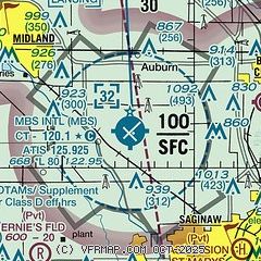
| Sectional chart |
|---|
|
 Download PDF
of official airport diagram from the FAA
| Airport distance calculator |
|---|
|
|
| Sunrise and sunset |
|---|
|
Times for 18-Apr-2024
| | Local
(UTC-4) | | Zulu
(UTC) |
|---|
| Morning civil twilight | | 06:18 | | 10:18 |
| Sunrise | | 06:48 | | 10:48 |
| Sunset | | 20:23 | | 00:23 |
| Evening civil twilight | | 20:53 | | 00:53 |
|
| Current date and time |
|---|
| Zulu (UTC) | 18-Apr-2024 22:46:03 |
|---|
| Local (UTC-4) | 18-Apr-2024 18:46:03 |
|---|
|
| METAR |
|---|
| KMBS | 182153Z AUTO 25005KT 10SM BKN090 OVC110 14/07 A2999 RMK AO2 SLP158 T01390072
|
KHYX
11nm SE | 182235Z AUTO 23005KT 10SM OVC100 15/07 A2997 RMK AO2
|
KIKW
11nm NW | 182235Z AUTO 24003KT 10SM OVC070 14/06 A2999 RMK AO2 T01360058
|
|
| TAF |
|---|
| KMBS | 181730Z 1818/1918 30008KT P6SM FEW030 FM182000 30008KT P6SM OVC100 FM190000 34006KT P6SM BKN020 OVC040 FM190400 02007KT 6SM -SHRA OVC015 WS020/21040KT FM190800 30012KT 5SM -SHRA OVC009
|
|
| NOTAMs |
|---|
NOTAMs are issued by the DoD/FAA and will open in a separate window not controlled by AirNav.
|
|


