FAA INFORMATION EFFECTIVE 18 APRIL 2024
Location
| FAA Identifier: | PAO |
| Lat/Long: | 37-27-40.0000N 122-06-54.2000W
37-27.666667N 122-06.903333W
37.4611111,-122.1150556
(estimated) |
| Elevation: | 6.8 ft. / 2.1 m (surveyed) |
| Variation: | 15E (1995) |
| Time zone: | UTC -7 (UTC -8 during Standard Time) |
| Zip code: | 94303 |
Airport Operations
| Airport use: | Open to the public |
| Activation date: | 04/1940 |
| Control tower: | yes |
| ARTCC: | OAKLAND CENTER |
| FSS: | OAKLAND FLIGHT SERVICE STATION |
| NOTAMs facility: | PAO (NOTAM-D service available) |
| Attendance: | 0600-2000 |
| Wind indicator: | lighted |
| Segmented circle: | yes |
| Lights: | ARPT LGTS OPERATE CONTINUOUSLY WHEN ATCT CLSD. |
| Beacon: | white-green (lighted land airport)
Operates sunset to sunrise. |
Airport Communications
| CTAF: | 118.6 |
| UNICOM: | 122.95 |
| ATIS: | 135.275 |
| PALO ALTO GROUND: | 125.0 [0700-2100] |
| PALO ALTO TOWER: | 118.6 [0700-2100] |
| NORCAL APPROACH: | 121.3 133.95 134.5 |
| NORCAL DEPARTURE: | 121.3 |
| WX AWOS-3PT at NUQ (4 nm SE): | 124.175 (650-386-0655) |
| WX AWOS-3P at SQL (7 nm NW): | 125.9 (650-593-0613) |
| WX ASOS at SJC (11 nm SE): | 126.95 (408-969-0838) |
| WX ASOS at HWD (12 nm N): | PHONE 510-786-3052 |
| WX ASOS at SFO (16 nm NW): | PHONE 650-827-8593 |
| WX ASOS at OAK (16 nm N): | PHONE 510-214-1776 |
| WX AWOS-3 at HAF (19 nm W): | 127.275 (650-728-5649) |
| WX ASOS at LVK (20 nm NE): | PHONE 925-606-5412 |
- FREQ 121.5 NOT AVAILABLE.
Nearby radio navigation aids
| VOR radial/distance | | VOR name | | Freq | | Var |
|---|
| OSIr046/8.9 | | WOODSIDE VOR/DME | | 113.90 | | 17E |
| SJCr287/9.6 | | SAN JOSE VOR/DME | | 114.10 | | 16E |
| SFOr111/15.6 | | SAN FRANCISCO VOR/DME | | 115.80 | | 17E |
| OAKr145/16.7 | | OAKLAND VOR/DME | | 116.80 | | 17E |
| SAUr124/30.6 | | SAUSALITO VOR/DME | | 116.20 | | 17E |
| CCRr168/35.2 | | CONCORD VOR/DME | | 117.00 | | 17E |
Airport Services
| Fuel available: | 100LL JET-A
100LL:SELF-FUELING AVAILBLE 24/7. |
| Parking: | tiedowns |
| Airframe service: | MAJOR |
| Powerplant service: | MAJOR |
| Bottled oxygen: | LOW |
Runway Information
Runway 13/31
| Dimensions: | 2443 x 70 ft. / 745 x 21 m |
| Surface: | asphalt, in good condition |
| Weight bearing capacity: | |
| Runway edge lights: | medium intensity |
| RUNWAY 13 | | RUNWAY 31 |
| Latitude: | 37-27.825110N | | 37-27.509270N |
| Longitude: | 122-07.059140W | | 122-06.746155W |
| Elevation: | 6.7 ft. | | 6.8 ft. |
| Traffic pattern: | left | | right |
| Runway heading: | 127 magnetic, 142 true | | 307 magnetic, 322 true |
| Markings: | basic, in good condition | | nonprecision, in good condition |
| Visual slope indicator: | 2-light PAPI on left (4.00 degrees glide path) | | 2-light PAPI on left (4.00 degrees glide path) |
| Runway end identifier lights: | yes | | yes |
| Touchdown point: | yes, no lights | | yes, no lights |
| Obstructions: | 8 ft. berm, lighted, 300 ft. from runway, 12:1 slope to clear
RY 13 +8 FT DIKE 300 FT FROM RY END, OBSTN LGTD. | | 5 ft. berm, lighted, 230 ft. from runway, 6:1 slope to clear
RY 31 +5 FT DIKE 230 FT FROM RY END, OBSTN LGTD. |
Airport Ownership and Management from official FAA records
| Ownership: | Publicly-owned |
| Owner: | CITY OF PALO ALTO
250 HAMILTON AVENUE
PALO ALTO, CA 94301-2531
Phone (650) 329-2444 |
| Manager: | ANDREW SWANSON
250 HAMILTON AVENUE
PALO ALTO, CA 94301-2531
Phone (650) 329-2444 |
Airport Operational Statistics
| Aircraft based on the field: | | 331 | | Single engine airplanes: | | 311 | | Multi engine airplanes: | | 18 | | Helicopters: | | 1 | | Gliders airplanes: | | 1 |
| |  | |
| Aircraft operations: avg 525/day * | | 60% | local general aviation | | 40% | transient general aviation | | <1% | air taxi | | * for 12-month period ending 31 July 2019 | |
Additional Remarks
| - | +100 FT TRANSMISSION TWRS E OF ARPT. |
| - | ARPT RSTRD BY ARPT OPR TO ACFT WITH MAX CERTD WT OF 12500 LBS OR LESS. |
| - | FOR CD WHEN ATCT IS CLSD CTC NORCAL APCH AT 916-361-3748. |
| - | BIRDS ON AND INVOF AP. |
| - | TPA 1000 FT W & 800 FT E. |
| - | NOISE SENSITIVE AREA SE THRU NW OF ARPT. RCMD ACFT LDG AT PALO ALTO ARPT FLY AT OR ABOVE 1500 FT UNTIL XNG THE BAYSHORE FREEWAY, AND RCMD ACFT DEP RWY 31 TURN 10 DEG RIGHT AFTER TKOF TIL RCHG DUMBARTON AUTO BRIDGE. |
| - | BE ALERT FOR PEDESTRAINS XNG A DIKE ROAD 8 FT HIGH AND 300 FT FROM RWY 13 END. |
| - | CONS PEDESTRIAN/VEHICLE ACT ON ACFT TAXI LANES NOT DESIGNATED AS TWY MOV AREAS. |
| - | ARPT SCTY PRODS IN EFCT. |
| - | ON APCH TO RWY 31 BE ALERT TO POSS STG UPDRAFT FM WIND TUNNEL LCTD ON W SIDE OF MOFFETT FEDERAL AIRFIELD. |
Instrument Procedures
NOTE: All procedures below are presented as PDF files. If you need a reader for these files, you should download the free Adobe Reader.NOT FOR NAVIGATION. Please procure official charts for flight.
FAA instrument procedures published for use from 18 April 2024 at 0901Z to 16 May 2024 at 0900Z.
STARs - Standard Terminal Arrivals |
|---|
| POINT REYES THREE | |
download (222KB) |
| POINT REYES THREE | |
download (222KB) |
IAPs - Instrument Approach Procedures |
|---|
| RNAV (GPS) RWY 31 **CHANGED** | |
download (231KB) |
| NOTE: Special Alternate Minimums apply | |
download (135KB) |
| NOTE: Special Take-Off Minimums/Departure Procedures apply | |
download (180KB) |
Other nearby airports with instrument procedures:
KNUQ - Moffett Federal Airfield (4 nm SE)
KSQL - San Carlos Airport (7 nm NW)
KSJC - Norman Y Mineta San Jose International Airport (11 nm SE)
KHWD - Hayward Executive Airport (12 nm N)
KSFO - San Francisco International Airport (16 nm NW)
KRHV - Reid-Hillview Airport of Santa Clara County (16 nm SE)
KOAK - Metro Oakland International Airport (16 nm N)
KHAF - Half Moon Bay Airport (19 nm W)
KLVK - Livermore Municipal Airport (20 nm NE)
|
|

Road maps at:
MapQuest
Bing
Google
| Aerial photo |
|---|
WARNING: Photo may not be current or correct
 Photo taken 11-Jan-2015
looking south-southwest.
Photo taken 11-Jan-2015
looking south-southwest.
Do you have a better or more recent aerial photo of Palo Alto Airport that you would like to share? If so, please send us your photo.
|
| Sectional chart |
|---|
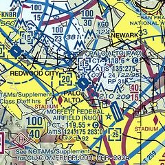
|
 Download PDF
of official airport diagram from the FAA
| Airport distance calculator |
|---|
|
|
| Sunrise and sunset |
|---|
|
Times for 24-Apr-2024
| | Local
(UTC-7) | | Zulu
(UTC) |
|---|
| Morning civil twilight | | 05:54 | | 12:54 |
| Sunrise | | 06:21 | | 13:21 |
| Sunset | | 19:52 | | 02:52 |
| Evening civil twilight | | 20:19 | | 03:19 |
|
| Current date and time |
|---|
| Zulu (UTC) | 24-Apr-2024 07:28:33 |
|---|
| Local (UTC-7) | 24-Apr-2024 00:28:33 |
|---|
|
| METAR |
|---|
| KPAO | 240347Z 20008KT 10SM BKN037 14/07 A3003 RMK LAST
|
KNUQ
5nm SE | 240715Z AUTO VRB04KT 10SM OVC039 14/07 A3005 RMK AO2
|
KSQL
7nm NW | 240715Z AUTO 20006KT 9SM OVC035 14/07 A3007 RMK AO2
|
KSJC
11nm SE | 240653Z 19007KT 10SM OVC038 15/06 A3006 RMK AO2 SLP178 T01500061
|
KHWD
12nm N | 240654Z AUTO 18007KT 10SM OVC036 16/07 A3005 RMK AO2 SLP185 T01560072
|
KOAK
15nm N | 240653Z 22012KT 10SM BKN038 14/08 A3006 RMK AO2 SLP178 T01390083 $
|
KSFO
15nm NW | 240656Z 20009KT 10SM BKN037 14/08 A3005 RMK AO2 SLP176 T01440078 $
|
KRHV
17nm SE | 240447Z 15010KT 10SM BKN030 14/07 A3006 RMK LAST
|
KHAF
19nm W | 240715Z AUTO 17008KT 5SM BR OVC037 13/12 A3006 RMK AO2
|
|
| TAF |
|---|
KSJC
11nm SE | 240539Z 2406/2506 17009KT P6SM OVC040 FM241100 16004KT P6SM SCT030 OVC035 FM241800 21008KT P6SM OVC050 FM242200 32013KT P6SM BKN050 FM250500 30008KT P6SM SCT035
|
KOAK
15nm N | 240539Z 2406/2512 23010KT P6SM SCT025 BKN045 FM240700 21009KT P6SM SCT030 BKN040 TEMPO 2410/2413 BKN030 FM242100 27013KT P6SM SCT025 BKN045 FM250900 28007KT P6SM BKN030
|
KSFO
15nm NW | 240539Z 2406/2512 16006KT P6SM SCT030 OVC035 TEMPO 2410/2414 BKN030 FM242000 23012G20KT P6SM FEW030 BKN035 FM250400 27009KT P6SM FEW025 FM250900 27010KT P6SM BKN025
|
|
| NOTAMs |
|---|
NOTAMs are issued by the DoD/FAA and will open in a separate window not controlled by AirNav.
|
|


