FAA INFORMATION EFFECTIVE 18 APRIL 2024
Location
| FAA Identifier: | VSF |
| Lat/Long: | 43-20-37.4000N 072-31-02.2000W
43-20.623333N 072-31.036667W
43.3437222,-72.5172778
(estimated) |
| Elevation: | 577.5 ft. / 176.0 m (surveyed) |
| Variation: | 15W (1995) |
| From city: | 3 miles NW of SPRINGFIELD, VT |
| Time zone: | UTC -4 (UTC -5 during Standard Time) |
| Zip code: | 05150 |
Airport Operations
| Airport use: | Open to the public |
| Activation date: | 10/1937 |
| Control tower: | no |
| ARTCC: | BOSTON CENTER |
| FSS: | BURLINGTON FLIGHT SERVICE STATION |
| NOTAMs facility: | VSF (NOTAM-D service available) |
| Attendance: | JAN-DEC SUN-SAT 0700-1800 |
| Pattern altitude: | 1677.5 ft. MSL
1100 FT AGL SNGL ENG; 1600 FT AGL MULT ENG. |
| Wind indicator: | lighted |
| Segmented circle: | no |
| Lights: | ACTVT REIL RWY 05; MIRL RWY 05/23 & 11/29 - CTAF. |
| Beacon: | white-green (lighted land airport)
Operates sunset to sunrise. |
Airport Communications
| CTAF/UNICOM: | 122.8 |
| WX ASOS: | 121.425 (802-886-6006) |
| WX ASOS at LEB (19 nm NE): | 118.65 (603-298-8780) |
- COMMUNICATIONS PRVDD BY BURLINGTON RADIO ON FREQ 122.5 (SPRINGFIELD RCO).
- APCH/DEP SVC PRVDD BY BOSTON ARTCC ON FREQS 134.7/269.475 (LEBANON RCAG).
Nearby radio navigation aids
| NDB name | | Hdg/Dist | | Freq | | Var | | ID |
|---|
| CLAREMONT | | 273/6.6 | | 233 | | 16W | | CNH | -.-. -. .... |
| HANOVER | | 229/26.1 | | 276 | | 15W | | LAH | .-.. .- .... |
| SMUTO | | 154/29.0 | | 221 | | 15W | | DYO | -.. -.-- --- |
Airport Services
| Fuel available: | 100LL JET-A JET-A+ |
| Parking: | hangars and tiedowns |
| Airframe service: | MAJOR |
| Powerplant service: | MAJOR |
| Bottled oxygen: | NONE |
| Bulk oxygen: | NONE |
Runway Information
Runway 5/23
| Dimensions: | 5501 x 100 ft. / 1677 x 30 m |
| Surface: | asphalt, in fair condition |
| Weight bearing capacity: | | Single wheel: | 32.0 | | Double wheel: | 45.0 |
|
| Runway edge lights: | medium intensity |
| RUNWAY 5 | | RUNWAY 23 |
| Latitude: | 43-20.335065N | | 43-21.079978N |
| Longitude: | 072-31.276235W | | 072-30.570868W |
| Elevation: | 570.9 ft. | | 554.2 ft. |
| Traffic pattern: | left | | left |
| Runway heading: | 050 magnetic, 035 true | | 230 magnetic, 215 true |
| Markings: | nonprecision, in fair condition | | nonprecision, in fair condition |
| Visual slope indicator: | 4-box VASI on left (4.00 degrees glide path) | | |
| Runway end identifier lights: | yes | | no |
| Touchdown point: | yes, no lights | | yes, no lights |
| Instrument approach: | LOC/DME | | |
| Obstructions: | 30 ft. trees, 383 ft. from runway, 120 ft. left of centerline, 6:1 slope to clear
RWY 05, +35 FT TREES, 0-200 FT FM END OF RWY, 250 FT LEFT OF CNTRLN. | | 27 ft. trees, 491 ft. from runway, 27 ft. right of centerline, 10:1 slope to clear
RWY 23, 1-20 FT TREES, 0-200 FT FM END OF RWY, 175-250 FT LEFT OF CNTRLN. |
Runway 11/29
| Dimensions: | 3000 x 75 ft. / 914 x 23 m |
| Surface: | asphalt, in good condition |
| Weight bearing capacity: | |
| Runway edge lights: | medium intensity |
| RUNWAY 11 | | RUNWAY 29 |
| Latitude: | 43-20.503808N | | 43-20.429695N |
| Longitude: | 072-31.580373W | | 072-30.911440W |
| Elevation: | 575.9 ft. | | 568.8 ft. |
| Traffic pattern: | left | | left |
| Runway heading: | 114 magnetic, 099 true | | 294 magnetic, 279 true |
| Markings: | basic, in fair condition | | basic, in fair condition |
| Runway end identifier lights: | no | | no |
| Touchdown point: | yes, no lights | | yes, no lights |
| Obstructions: | 61 ft. trees, 457 ft. from runway, 187 ft. right of centerline, 4:1 slope to clear
RWY 11, +40 FT TREES, 0-400 FT FM END OF RWY CNTRLN. | | none |
Airport Ownership and Management from official FAA records
| Ownership: | Publicly-owned |
| Owner: | STATE OF VERMONT
219 N MAIN ST
BARRE, VT 05641
Phone 802-279-2647 |
| Manager: | ROLLIN TEBBETTS
219 N MAIN ST
BARRE, VT 05641
Phone 802-585-5586 |
Airport Operational Statistics
| Aircraft based on the field: | | 25 | | Single engine airplanes: | | 11 | | Multi engine airplanes: | | 1 | | Jet airplanes: | | 1 | | Gliders airplanes: | | 12 |
| |  | |
| Aircraft operations: avg 127/week * | | 57% | local general aviation | | 38% | transient general aviation | | 3% | air taxi | | 2% | military | | * for 12-month period ending 31 December 2017 | |
Additional Remarks
| E143 | LOC ONLY |
| - | CFR NOT AVBL ON ARPT. |
| - | FOR CD IF UNA TO CTC ON FSS FREQ, CTC BOSTON ARTCC AT 603-879-6859 . |
| - | RWY CONDS MAY NOT BE MNT OR RPRTD WHEN ARPT IS UNATNDD. |
| - | GEESE ON & INVOF ARPT. |
| - | APRON & TWYS A & B PAVEMENT CAPACITY IS S-46 & D-62. |
| - | NOISE SENSITIVE AREA WEST OF ARPT. |
| - | RWY 23 IS PREFERRED FOR DAY, VFR, NO WIND CONDS. |
| - | MNTN RCMDD PAT ALT ON DOWNWIND LEG FOR RWY 05. |
| - | COLD TEMPERATURE AIRPORT. ALTITUDE CORRECTION REQUIRED AT OR BELOW -20C. |
Instrument Procedures
NOTE: All procedures below are presented as PDF files. If you need a reader for these files, you should download the free Adobe Reader.NOT FOR NAVIGATION. Please procure official charts for flight.
FAA instrument procedures published for use from 18 April 2024 at 0901Z to 16 May 2024 at 0900Z.
IAPs - Instrument Approach Procedures |
|---|
| RNAV (GPS) RWY 05 | |
download (227KB) |
| LOC RWY 05 | |
download (251KB) |
| NOTE: Special Alternate Minimums apply | |
download (129KB) |
| NOTE: Special Take-Off Minimums/Departure Procedures apply | |
download (403KB) |
Other nearby airports with instrument procedures:
KCNH - Claremont Municipal Airport (7 nm E)
2B3 - Parlin Field Airport (15 nm E)
KLEB - Lebanon Municipal Airport (19 nm NE)
KRUT - Rutland/Southern Vermont Regional Airport (22 nm NW)
KEEN - Dillant/Hopkins Airport (29 nm S)
|
|

Road maps at:
MapQuest
Bing
Google
| Aerial photo |
|---|
WARNING: Photo may not be current or correct
 Photo by Larry Perry
Photo taken 12-Sep-2014
looking northeast.
Photo by Larry Perry
Photo taken 12-Sep-2014
looking northeast.
Do you have a better or more recent aerial photo of Hartness State Airport (Springfield) that you would like to share? If so, please send us your photo.
|
| Sectional chart |
|---|
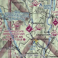
|
| Airport distance calculator |
|---|
|
|
| Sunrise and sunset |
|---|
|
Times for 23-Apr-2024
| | Local
(UTC-4) | | Zulu
(UTC) |
|---|
| Morning civil twilight | | 05:24 | | 09:24 |
| Sunrise | | 05:54 | | 09:54 |
| Sunset | | 19:42 | | 23:42 |
| Evening civil twilight | | 20:13 | | 00:13 |
|
| Current date and time |
|---|
| Zulu (UTC) | 23-Apr-2024 11:34:40 |
|---|
| Local (UTC-4) | 23-Apr-2024 07:34:40 |
|---|
|
| METAR |
|---|
| KVSF | 231054Z AUTO 00000KT 10SM CLR M02/M04 A3016 RMK AO2 SLP220 T10171044
|
KLEB
20nm NE | 231053Z 00000KT 10SM CLR M03/M06 A3015 RMK AO2 SLP216 T10281056
|
|
| TAF |
|---|
KLEB
20nm NE | 230904Z 2309/2406 00000KT P6SM SKC FM231300 19006KT P6SM SKC FM231600 19012G22KT P6SM SCT250 FM232200 19009KT P6SM BKN250
|
KRUT
22nm NW | 230520Z 2306/2406 13009KT P6SM SKC FM231200 VRB04KT P6SM SKC FM231400 19008KT P6SM FEW200 FM231600 19011G18KT P6SM FEW200 FM232300 16010KT P6SM BKN120 FM240200 13012KT P6SM VCSH OVC090
|
|
| NOTAMs |
|---|
NOTAMs are issued by the DoD/FAA and will open in a separate window not controlled by AirNav.
|
|

