FAA INFORMATION EFFECTIVE 18 APRIL 2024
Location
| FAA Identifier: | WEA |
| Lat/Long: | 32-44-46.6321N 097-40-56.8279W
32-44.777202N 097-40.947132W
32.7462867,-97.6824522
(estimated) |
| Elevation: | 991.2 ft. / 302.1 m (surveyed) |
| Variation: | 05E (2010) |
| From city: | 5 miles E of WEATHERFORD, TX |
| Time zone: | UTC -5 (UTC -6 during Standard Time) |
| Zip code: | 76087 |
Airport Operations
| Airport use: | Open to the public |
| Activation date: | 01/1961 |
| Control tower: | no |
| ARTCC: | FORT WORTH CENTER |
| FSS: | FORT WORTH FLIGHT SERVICE STATION |
| NOTAMs facility: | FTW (NOTAM-D service available) |
| Attendance: | 0800-1800 |
| Wind indicator: | lighted |
| Segmented circle: | no |
| Lights: | SS-SR |
Airport Communications
| CTAF/UNICOM: | 122.7 |
| REGIONAL APPROACH: | 135.975 |
| REGIONAL DEPARTURE: | 135.975 |
| DODJE STAR: | 125.2 125.9 |
| GARLAND DP: | 125.8 |
| LIKES STAR: | 125.8 ;SOUTH 135.975 ;NORTH |
| MOTZA STAR: | 118.1 ;SOUTH 125.8 ;NORTH |
| REEKO STAR: | 125.2 |
| SASIE STAR: | 124.3 |
| TRUUK RNAV STAR: | 118.1 |
| WESAT STAR: | 118.1 ;SOUTH 125.8 ;NORTH |
| WX ASOS at FTW (17 nm E): | PHONE 817-740-3346 |
| WX ASOS at MWL (19 nm W): | 135.075 (940-325-2457) |
| WX AWOS-3T at GDJ (20 nm S): | 118.925 (817-573-7514) |
Nearby radio navigation aids
| VOR radial/distance | | VOR name | | Freq | | Var |
|---|
| MQPr077/15.9 | | MILLSAP VORTAC | | 117.70 | | 09E |
| FUZr245/26.8 | | RANGER VORTAC | | 115.70 | | 06E |
| TTTr251/33.2 | | MAVERICK VOR/DME | | 113.10 | | 06E |
Airport Services
| Fuel available: | 100LL
100LL:FUEL 24 HRS SELF SERVE. |
| Parking: | hangars and tiedowns |
| Bottled oxygen: | NONE |
| Bulk oxygen: | NONE |
Runway Information
Runway 17/35
| Dimensions: | 2892 x 40 ft. / 881 x 12 m |
| Surface: | asphalt, in good condition |
| Weight bearing capacity: | |
| Runway edge lights: | low intensity
NSTD DSPLCD THR LGTS, SINGLE GREEN LGT EACH SIDE OF RWY. |
| Operational restrictions: | RESTRICTED TO ACFT 7500 LBS OR LESS. |
| RUNWAY 17 | | RUNWAY 35 |
| Latitude: | 32-45.015632N | | 32-44.538772N |
| Longitude: | 097-40.945290W | | 097-40.948973W |
| Elevation: | 988.6 ft. | | 982.6 ft. |
| Traffic pattern: | left | | left |
| Runway heading: | 175 magnetic, 180 true | | 355 magnetic, 000 true |
| Displaced threshold: | 220 ft. | | no |
| Markings: | basic, in good condition | | basic, in good condition |
| Touchdown point: | yes, no lights | | yes, no lights |
| Obstructions: | 40 ft. tree, 526 ft. from runway, 44 ft. left of centerline, 8:1 slope to clear
5 FT FENCE 40 FT FM THR 120 FT R OF CNTRLN; 20 FT DROP-OFF 10 FT FROM THR 0B. | | 40 ft. trees, 400 ft. from runway, 125 ft. right of centerline, 5:1 slope to clear
APCH SLOPE 20:1 AT DSPLCD THR. |
Airport Ownership and Management from official FAA records
| Ownership: | Privately-owned |
| Owner: | PARKER COUNTY AIRPORT HANGARS ASSOC
4607 FOREST HILL CIRCLE
FORT WORTH, TX 76140
Phone 817-599-9210 |
| Manager: | BRET PRIVITT
4607 FOREST HILL CIRCLE
FORT WORTH, TX 76140
Phone (817) 822-7205 |
Airport Operational Statistics
| Aircraft based on the field: | | 86 | | Single engine airplanes: | | 80 | | Multi engine airplanes: | | 6 |
| |  | |
| Aircraft operations: avg 137/day * | | 75% | local general aviation | | 25% | transient general aviation | | <1% | military | | * for 12-month period ending 21 September 2022 | |
Additional Remarks
| - | FOR CD CTC REGIONAL APCH AT 972-615-2799. |
| - | WILDLIFE ON AND INVOF APRT. |
| - | TWY ON WEST SIDE OF RWY CLSD TO PUBLIC INDEFLY. |
| - | ARPT CLSD TO TRANSIENT STUDENT TFC. |
| - | CLOSED TO ULTRALIGHT TRAFFIC. |
Instrument Procedures
NOTE: All procedures below are presented as PDF files. If you need a reader for these files, you should download the free Adobe Reader.NOT FOR NAVIGATION. Please procure official charts for flight.
FAA instrument procedures published for use from 18 April 2024 at 0901Z to 16 May 2024 at 0900Z.
STARs - Standard Terminal Arrivals |
|---|
| LIKES THREE (RNAV) | |
download (204KB) |
| MOTZA ONE | |
2 pages:
[1] [2] (481KB) |
| REEKO THREE (RNAV) | |
download (214KB) |
| SASIE SEVEN | |
2 pages:
[1] [2] (498KB) |
| TRUUK TWO (RNAV) | |
download (218KB) |
| WESAT TWO (RNAV) | |
download (206KB) |
IAPs - Instrument Approach Procedures |
|---|
| VOR/DME-A | |
download (157KB) |
Departure Procedures |
|---|
| GARLAND FIVE | |
2 pages:
[1] [2] (322KB) |
| KINGDOM FOUR | |
2 pages:
[1] [2] (343KB) |
| KUSSO ONE (RNAV) | |
2 pages:
[1] [2] (313KB) |
| NANDR TWO (RNAV) | |
2 pages:
[1] [2] (307KB) |
| SWABR ONE (RNAV) | |
2 pages:
[1] [2] (313KB) |
| NOTE: Special Take-Off Minimums/Departure Procedures apply | |
download (113KB) |
Other nearby airports with instrument procedures:
50F - Bourland Field Airport (11 nm SE)
KNFW - Fort Worth Naval Air Station JRB (Carswell Field) Airport (12 nm E)
KFTW - Fort Worth Meacham International Airport (17 nm E)
4T2 - Kenneth Copeland Airport (17 nm NE)
KMWL - Mineral Wells Regional Airport (19 nm W)
KGDJ - Granbury Regional Airport (20 nm S)
|
|

Road maps at:
MapQuest
Bing
Google
| Aerial photo |
|---|
WARNING: Photo may not be current or correct
 Photo by Kim Fuller
Photo taken 06-Apr-2017
looking south.
Photo by Kim Fuller
Photo taken 06-Apr-2017
looking south.
Do you have a better or more recent aerial photo of Parker County Airport that you would like to share? If so, please send us your photo.
|
| Sectional chart |
|---|
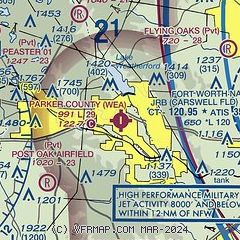
|
| Airport distance calculator |
|---|
|
|
| Sunrise and sunset |
|---|
|
Times for 25-Apr-2024
| | Local
(UTC-5) | | Zulu
(UTC) |
|---|
| Morning civil twilight | | 06:24 | | 11:24 |
| Sunrise | | 06:50 | | 11:50 |
| Sunset | | 20:07 | | 01:07 |
| Evening civil twilight | | 20:33 | | 01:33 |
|
| Current date and time |
|---|
| Zulu (UTC) | 25-Apr-2024 09:52:16 |
|---|
| Local (UTC-5) | 25-Apr-2024 04:52:16 |
|---|
|
| METAR |
|---|
KNFW
12nm E | 250852Z AUTO 18014G24KT 10SM SCT019 OVC055 23/18 A3000 RMK AO2 CIG 018 S SLP143 T02280183 55006 $
|
KFTW
17nm E | 250853Z 18013G20KT 10SM SCT018 OVC050 22/19 A2999 RMK AO2 SLP147 T02220189 55007
|
KGDJ
19nm S | AWOS-3 118.925 817-573-7514
250935Z AUTO 17009KT 10SM OVC050 22/18 A3001 RMK AO2 T02160183
|
KMWL
20nm W | 250853Z AUTO 16011G17KT 10SM OVC050 22/18 A2997 RMK AO2 SLP137 T02220183 58009
|
KFWS
22nm SE | 250935Z AUTO 17008KT 10SM OVC060 21/18 A3002 RMK AO2 T02150183
|
KAFW
23nm NE | 250853Z 18012KT 10SM BKN060 OVC250 23/18 A2999 RMK AO2 SLP141 T02330183 56008
|
|
| TAF |
|---|
KNFW
12nm E | 2507/2607 17010KT 6000 BR BKN011 QNH2996INS BECMG 2507/2509 17010KT 6000 BR BKN009 QNH2986INS FM252000 15016G26KT 9999 NSW BKN011 QNH2977INS BECMG 2602/2604 9999 VCTS BKN009 BKN011CB BKN020 QNH2973INS AUTOMATED SENSOR METWATCH 2507 TIL 2511 TX27/2521Z TN20/2512Z FN00251
|
KFTW
17nm E | 250538Z 2506/2612 16007KT P6SM BKN070 OVC250 FM251200 17008KT P6SM OVC028 FM251500 17015KT P6SM OVC015 FM251900 17019G29KT P6SM BKN021 FM260000 16017G27KT P6SM OVC035 FM260400 17015G30KT P6SM OVC022
|
|
| NOTAMs |
|---|
NOTAMs are issued by the DoD/FAA and will open in a separate window not controlled by AirNav.
|
|


