FAA INFORMATION EFFECTIVE 21 MARCH 2024
Location
| FAA Identifier: | BDN |
| Lat/Long: | 44-05-40.4190N 121-12-00.7960W
44-05.673650N 121-12.013267W
44.0945608,-121.2002211
(estimated) |
| Elevation: | 3459.4 ft. / 1054.4 m (surveyed) |
| Variation: | 14E (2025) |
| From city: | 5 miles NE of BEND, OR |
| Time zone: | UTC -7 (UTC -8 during Standard Time) |
| Zip code: | 97701 |
Airport Operations
| Airport use: | Open to the public |
| Activation date: | 06/1942 |
| Control tower: | no |
| ARTCC: | SEATTLE CENTER |
| FSS: | MC MINNVILLE FLIGHT SERVICE STATION |
| NOTAMs facility: | MMV (NOTAM-D service available) |
| Attendance: | SAT-SUN 0800-1700, ALL MON-FRI 0730-1800 |
| Wind indicator: | lighted |
| Segmented circle: | yes
SEGMENTED CRC LCTD AT NE END OF ARPT. |
| Lights: | ACTVT REIL RWY 16/34; PAPI RWY 16/34; MIRL RWY 16/34 - CTAF. |
| Beacon: | white-green (lighted land airport)
Operates sunset to sunrise. |
Airport Communications
| CTAF/UNICOM: | 123.0 |
| WX AWOS-3: | 134.425 (541-382-1477) |
| WX ASOS at RDM (10 nm N): | 119.025 (541-504-8743) |
| WX AWOS-3PT at S21 (17 nm SW): | 128.325 (541-593-4623) |
| WX AWOS-3PT at S39 (17 nm NE): | 118.325 (541-447-4060) |
- APCH/DEP CTL SVC PRVDD BY SEATTLE ARTCC (ZSE) ON FREQS126.15/269.475 (REDMOND RCAG).
Nearby radio navigation aids
| VOR radial/distance | | VOR name | | Freq | | Var |
|---|
| DSDr137/10.5 | | DESCHUTES VORTAC | | 117.60 | | 18E |
Airport Services
| Fuel available: | 100LL JET-A |
| Parking: | hangars and tiedowns |
| Airframe service: | MAJOR |
| Powerplant service: | MAJOR |
| Bottled oxygen: | HIGH/LOW |
| Bulk oxygen: | HIGH |
Runway Information
Runway 16/34
| Dimensions: | 5201 x 75 ft. / 1585 x 23 m |
| Surface: | asphalt, in good condition |
| Weight bearing capacity: | |
| Runway edge lights: | medium intensity |
| RUNWAY 16 | | RUNWAY 34 |
| Latitude: | 44-06.101527N | | 44-05.245763N |
| Longitude: | 121-12.012867W | | 121-12.013652W |
| Elevation: | 3403.0 ft. | | 3459.4 ft. |
| Traffic pattern: | right | | left |
| Runway heading: | 166 magnetic, 180 true | | 346 magnetic, 360 true |
| Markings: | nonprecision, in good condition | | nonprecision, in good condition |
| Visual slope indicator: | 4-light PAPI on left (3.00 degrees glide path) | | 4-light PAPI on left (3.00 degrees glide path) |
| Runway end identifier lights: | yes | | yes |
| Touchdown point: | yes, no lights | | yes, no lights |
| Obstructions: | 18 ft. trees, 542 ft. from runway, 100 ft. right of centerline, 19:1 slope to clear | | 52 ft. tree, 1496 ft. from runway, 250 ft. left of centerline, 25:1 slope to clear |
Airport Ownership and Management from official FAA records
| Ownership: | Publicly-owned |
| Owner: | CITY OF BEND
BOX 431
BEND, OR 97701
Phone 541-389-0258 |
| Manager: | TRACY WILLIAMS
BOX 431
BEND, OR 97709
Phone 541-647-0828 |
Airport Operational Statistics
| Aircraft based on the field: | | 226 | | Single engine airplanes: | | 172 | | Multi engine airplanes: | | 15 | | Jet airplanes: | | 8 | | Helicopters: | | 22 | | Gliders airplanes: | | 9 |
- GLIDER OPR ON & INVOF ARPT.
| |  | |
| Aircraft operations: avg 387/day * | | 50% | local general aviation | | 49% | transient general aviation | | <1% | air taxi | | <1% | military | | * for 12-month period ending 15 June 2020 | |
Additional Remarks
| - | BOTH TWYS PARALLEL TO RY 16/34 MKD BY REFLECTORS. |
| - | RP FIXED WING TO RMN WEST OF RWY USING RP RWY 16 AND LP RWY 34. ROTOR WING TO RMN EAST OF RWY AND USE RP 34 AND LP 16. FIXED WING ACFT-NO TURNS BFR END OF RWY. |
| - | FOR CD CTC SEATTLE ARTCC AT 253-351-3694. |
| - | CALM WIND RWY IS RWY 16 |
| - | NOISE ABATEMENT PROCEDURES IN EFFECT, CALL FBO AT (541) 388-0019 |
| - | BE AWARE, INTENSE HELICOPTER TRAINING CONTINUALLY IN PROGRESS. |
| - | EXTENSIVE GEESE ACTIVITY REPORTED ON AND NEAR ARPT YEAR AROUND. DEER AND OTHER WILDLIFE MAY BE PRESENT. |
| - | APRON AREAS MAY BE HEAVILY CONGESTED AT TIMES WITH SVC VEHICLES, PEDESTRIAN AND AUTOMOBILE TFC. |
| - | TAXILANES AND APRON ARE NSTD. ACFT MAY REQUIRE WING WALKERS, PARKING GUIDANCE AND/OR TUGGING AT PILOT DISCRETION TO INSURE ACFT CLEARANCE FROM OBSTACLES. |
| - | TO AVOID PROPERTY DAMAGE EXERCISE JUDGEMENT AND COURTESY DURING RUN-UP IN VICINITY OF HANGARS. |
Instrument Procedures
NOTE: All procedures below are presented as PDF files. If you need a reader for these files, you should download the free Adobe Reader.NOT FOR NAVIGATION. Please procure official charts for flight.
FAA instrument procedures published for use from 21 March 2024 at 0901Z to 18 April 2024 at 0900z.
IAPs - Instrument Approach Procedures |
|---|
| RNAV (GPS) RWY 34 **CHANGED** | |
download (249KB) |
| RNAV (GPS) Y RWY 16 **CHANGED** | |
download (288KB) |
| RNAV (GPS) Z RWY 16 | |
download (280KB) |
| VOR RWY 16 | |
download (280KB) |
| NOTE: Special Alternate Minimums apply | |
download (211KB) |
|
|---|
| BEND TWO (OBSTACLE) | |
download (394KB) |
| NOTE: Special Take-Off Minimums/Departure Procedures apply | |
download (573KB) |
Other nearby airports with instrument procedures:
KRDM - Roberts Field Airport (10 nm N)
S21 - Sunriver Airport (17 nm SW)
S39 - Prineville Airport (17 nm NE)
S33 - Madras Municipal Airport (35 nm N)
62S - Christmas Valley Airport (57 nm SE)
|
|

Road maps at:
MapQuest
Bing
Google
| Aerial photo |
|---|
WARNING: Photo may not be current or correct
 Photo taken 07-Mar-2014
looking northwest.
Photo taken 07-Mar-2014
looking northwest.
Do you have a better or more recent aerial photo of Bend Municipal Airport that you would like to share? If so, please send us your photo.
|
| Sectional chart |
|---|
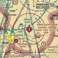
|
| Airport distance calculator |
|---|
|
|
| Sunrise and sunset |
|---|
|
Times for 16-Apr-2024
| | Local
(UTC-7) | | Zulu
(UTC) |
|---|
| Morning civil twilight | | 05:49 | | 12:49 |
| Sunrise | | 06:19 | | 13:19 |
| Sunset | | 19:50 | | 02:50 |
| Evening civil twilight | | 20:20 | | 03:20 |
|
| Current date and time |
|---|
| Zulu (UTC) | 16-Apr-2024 14:30:27 |
|---|
| Local (UTC-7) | 16-Apr-2024 07:30:27 |
|---|
|
| METAR |
|---|
| KBDN | 161415Z AUTO 00000KT 10SM 02/M01 A3022 RMK AO2
|
KRDM
10nm N | 161356Z 00000KT 10SM CLR 00/M02 A3023 RMK AO2 SLP246 T00001022
|
KS21
17nm SW | 161415Z AUTO 21003KT 10SM CLR 00/M03 A3025 RMK AO2
|
KS39
17nm NE | 161415Z AUTO 00000KT 10SM CLR 00/M01 A3024 RMK AO2
|
|
| TAF |
|---|
| KBDN | 161120Z 1612/1712 VRB04KT P6SM FEW050 SCT150 BKN250 FM162100 33010G20KT P6SM SCT050 SCT250 FM170300 34006KT P6SM FEW050
|
KRDM
10nm N | 161120Z 1612/1712 VRB03KT P6SM FEW050 SCT150 BKN250 FM161900 33012G22KT P6SM SCT050 SCT250 FM170400 35006KT P6SM SCT050
|
|
| NOTAMs |
|---|
NOTAMs are issued by the DoD/FAA and will open in a separate window not controlled by AirNav.
|
|


