FAA INFORMATION EFFECTIVE 18 APRIL 2024
Location
| FAA Identifier: | MDW |
| Lat/Long: | 41-47-09.5000N 087-45-08.7000W
41-47.158333N 087-45.145000W
41.7859722,-87.7524167
(estimated) |
| Elevation: | 619.8 ft. / 188.9 m (surveyed) |
| Variation: | 04W (2015) |
| From city: | 9 miles SW of CHICAGO, IL |
| Time zone: | UTC -5 (UTC -6 during Standard Time) |
| Zip code: | 60638 |
Airport Operations
| Airport use: | Open to the public |
| Activation date: | 04/1940 |
| Control tower: | yes |
| ARTCC: | CHICAGO CENTER |
| FSS: | KANKAKEE FLIGHT SERVICE STATION |
| NOTAMs facility: | MDW (NOTAM-D service available) |
| Attendance: | CONTINUOUS |
| Wind indicator: | lighted |
| Segmented circle: | no |
| Beacon: | white-green (lighted land airport)
Operates sunset to sunrise. |
| Fire and rescue: | ARFF index C |
| Airline operations: | ARFF INDEX "D" EQPT AVBL WITH 8 HRS NOTIFICATION TO ARPT OPNS 773-838-0677. |
| International operations: | international airport of entry |
Airport Communications
| UNICOM: | 122.95 |
| WX ASOS: | PHONE 773-884-4424 |
| MIDWAY GROUND: | 118.075 |
| MIDWAY TOWER: | 135.2 269.125 |
| CHICAGO APPROACH: | 128.2 126.05 |
| CHICAGO DEPARTURE: | 128.2 126.05 |
| CLEARANCE DELIVERY: | 124.625 |
| CLASS C: | 119.45 269.125 |
| CLASS C/S: | 135.2 |
| D-ATIS: | 132.75 |
| EMERG: | 121.5 |
| GOSHEN STAR: | 128.2 |
| MOTIF STAR: | 128.2 |
| WX ASOS at ORD (13 nm NW): | PHONE 773-462-0118 |
| WX AWOS-3PT at IGQ (18 nm SE): | 119.275 (708-889-6319) |
| WX AWOS-3PT at GYY (18 nm SE): | 134.575 (219-944-0010) |
| WX AWOS-3PT at LOT (19 nm SW): | 126.675 (815-588-4802) |
| WX AWOS-3 at 06C (20 nm NW): | 128.275 ((847) 895-2887) |
Nearby radio navigation aids
| VOR radial/distance | | VOR name | | Freq | | Var |
|---|
| CGTr332/18.4 | | CHICAGO HEIGHTS VORTAC | | 114.20 | | 02E |
| DPAr101/27.4 | | DUPAGE VOR/DME | | 108.40 | | 02E |
| OBKr163/27.6 | | NORTHBROOK VOR/DME | | 113.00 | | 02W |
| JOTr058/29.2 | | JOLIET VOR/DME | | 112.30 | | 02E |
| EONr001/31.0 | | PEOTONE VORTAC | | 113.20 | | 02E |
Airport Services
| Fuel available: | 100LL JET-A1+ |
| Parking: | hangars and tiedowns |
| Airframe service: | MAJOR |
| Powerplant service: | MAJOR |
| Bottled oxygen: | LOW |
| Bulk oxygen: | LOW |
Runway Information
Runway 13C/31C
| Dimensions: | 6522 x 150 ft. / 1988 x 46 m |
| Surface: | asphalt/concrete/grooved, in excellent condition |
| Weight bearing capacity: | | PCN 61 /F/D/X/T | | Single wheel: | 95.0 | | Double wheel: | 165.0 | | Double tandem: | 250.0 |
|
| Runway edge lights: | high intensity |
| RUNWAY 13C | | RUNWAY 31C |
| Latitude: | 41-47.494443N | | 41-46.754460N |
| Longitude: | 087-45.664207W | | 087-44.624433W |
| Elevation: | 607.0 ft. | | 611.6 ft. |
| Traffic pattern: | left | | left |
| Runway heading: | 138 magnetic, 134 true | | 318 magnetic, 314 true |
| Displaced threshold: | 463 ft. | | 696 ft. |
| Declared distances: | TORA:6522 TODA:6522 ASDA:6522 LDA:6059 | | TORA:6522 TODA:6522 ASDA:6522 LDA:5826 |
| Markings: | precision, in good condition | | precision, in good condition |
| Visual slope indicator: | 4-light PAPI on right (3.00 degrees glide path) | | 4-light PAPI on left (3.00 degrees glide path) |
| RVR equipment: | touchdown, rollout | | touchdown, rollout |
| Approach lights: | RLLS | | RLLS |
| Runway end identifier lights: | no | | yes |
| Centerline lights: | yes | | yes |
| Touchdown point: | yes, no lights | | yes, no lights |
| Instrument approach: | ILS/DME | | ILS/DME |
| Obstructions: | 15 ft. road, 200 ft. from runway, 225 ft. right of centerline
RWY 13C APCH RATIO 16:1 AT DSPLCD THLD. TREE 453 FT R 915 FT FROM DSPLCD THLD. | | 47 ft. road, 200 ft. from runway, 225 ft. left of centerline
RWY 31C APCH RATIO 24:1 AT DSPLCD THR. TREE 1211 FT FROM DSPLCD THR 459 FT R. |
Runway 4R/22L
| Dimensions: | 6445 x 150 ft. / 1964 x 46 m |
| Surface: | asphalt/concrete/grooved, in excellent condition |
| Weight bearing capacity: | | PCN 62 /F/D/X/T | | Single wheel: | 95.0 | | Double wheel: | 165.0 | | Double tandem: | 250.0 |
|
| Runway edge lights: | high intensity |
| RUNWAY 4R | | RUNWAY 22L |
| Latitude: | 41-46.749740N | | 41-47.519850N |
| Longitude: | 087-45.559095W | | 087-44.583513W |
| Elevation: | 619.7 ft. | | 605.2 ft. |
| Traffic pattern: | left | | left |
| Runway heading: | 047 magnetic, 043 true | | 227 magnetic, 223 true |
| Displaced threshold: | 518 ft. | | 635 ft. |
| Declared distances: | TORA:6446 TODA:6446 ASDA:6446 LDA:5928 | | TORA:6446 TODA:6446 ASDA:6446 LDA:5812 |
| Markings: | precision, in good condition | | precision, in good condition |
| Visual slope indicator: | 4-light PAPI on left (3.00 degrees glide path) | | 4-light PAPI on right (3.00 degrees glide path) |
| RVR equipment: | touchdown, rollout | | touchdown, rollout |
| Runway end identifier lights: | yes | | yes |
| Centerline lights: | yes | | yes |
| Touchdown point: | yes, no lights | | yes, no lights |
| Instrument approach: | ILS/DME | | |
| Obstructions: | 15 ft. road, 200 ft. from runway, 325 ft. right of centerline
RWY 04R APCH RATIO 16:1 AT DSPLCD THLD. TREE 547 FT R 1122 FT FROM DSPLCD THLD. | | 15 ft. road, 200 ft. from runway, 350 ft. left of centerline
RWY 22L APCH RATIO 19:1 AT DSPLCD THLD. LGT POLE 474 FT R 674 FT FROM DSPLCD THLD. |
Runway 4L/22R
| Dimensions: | 5507 x 150 ft. / 1679 x 46 m |
| Surface: | asphalt/grooved, in good condition |
| Weight bearing capacity: | | PCN 69 /F/D/X/T | | Single wheel: | 60.0 | | Double wheel: | 120.0 |
|
| Runway edge lights: | medium intensity |
| RUNWAY 4L | | RUNWAY 22R |
| Latitude: | 41-46.882110N | | 41-47.540227N |
| Longitude: | 087-45.671675W | | 087-44.838142W |
| Elevation: | 618.5 ft. | | 605.2 ft. |
| Traffic pattern: | left | | left |
| Runway heading: | 047 magnetic, 043 true | | 227 magnetic, 223 true |
| Displaced threshold: | 758 ft. | | 878 ft. |
| Declared distances: | TORA:5507 TODA:5507 ASDA:5507 LDA:4749 | | TORA:5507 TODA:5507 ASDA:5507 LDA:4629 |
| Markings: | nonprecision, in good condition | | nonprecision, in good condition |
| Visual slope indicator: | 4-light PAPI on left (3.00 degrees glide path) | | 4-light PAPI on left (3.00 degrees glide path) |
| Runway end identifier lights: | no | | no |
| Touchdown point: | yes, no lights | | yes, no lights |
| Obstructions: | 15 ft. road, 200 ft. from runway, 25 ft. left of centerline
RWY 04L APCH RATIO 19:1 AT DSPLCD THLD. TREES 178 FT L 1313 FT FROM DSPLCD THLD. | | 15 ft. road, 200 ft. from runway, 125 ft. right of centerline
RWY 22R APCH RATIO 37:1 AT DSPLCD THR. TREE 2490 FT FROM DSPLCD THR 319 FT L. |
Runway 13L/31R
| Dimensions: | 5141 x 150 ft. / 1567 x 46 m |
| Surface: | asphalt/concrete/grooved, in good condition |
| Weight bearing capacity: | | PCN 59 /R/B/W/T | | Single wheel: | 80.0 | | Double wheel: | 125.0 |
|
| Runway edge lights: | medium intensity |
| RUNWAY 13L | | RUNWAY 31R |
| Latitude: | 41-47.538998N | | 41-46.956062N |
| Longitude: | 087-45.476450W | | 087-44.656462W |
| Elevation: | 606.1 ft. | | 608.3 ft. |
| Traffic pattern: | left | | left |
| Runway heading: | 138 magnetic, 134 true | | 318 magnetic, 314 true |
| Displaced threshold: | 752 ft. | | no |
| Markings: | nonprecision, in good condition | | nonprecision, in good condition |
| Visual slope indicator: | | | 4-light PAPI on left (3.00 degrees glide path) |
| Runway end identifier lights: | no | | no |
| Touchdown point: | yes, no lights | | yes, no lights |
| Obstructions: | 15 ft. road, 200 ft. from runway | | 34 ft. pole, lighted, 656 ft. from runway, 285 ft. right of centerline, 13:1 slope to clear |
Runway 13R/31L
| Dimensions: | 3859 x 60 ft. / 1176 x 18 m |
| Surface: | asphalt, in excellent condition |
| Weight bearing capacity: | | PCN 42 /R/B/X/T | | Single wheel: | 12.5 |
|
| Runway edge lights: | medium intensity |
| Operational restrictions: | RWYS 13R/31L & 04L/22R NOT AVBL FOR SKEDD ACR OPNS WITH MORE THAN 9 PSGR SEATS OR UNSKED ACR AT LEAST 31 PSGR SEATS. |
| RUNWAY 13R | | RUNWAY 31L |
| Latitude: | 41-47.284182N | | 41-46.846285N |
| Longitude: | 087-45.528325W | | 087-44.913083W |
| Elevation: | 606.9 ft. | | 612.9 ft. |
| Traffic pattern: | left | | left |
| Runway heading: | 138 magnetic, 134 true | | 318 magnetic, 314 true |
| Markings: | basic, in good condition | | basic, in good condition |
| Runway end identifier lights: | no | | no |
| Touchdown point: | yes, no lights | | yes, no lights |
| Obstructions: | 55 ft. tree, 1504 ft. from runway, 214 ft. right of centerline, 23:1 slope to clear | | 59 ft. tree, 1737 ft. from runway, 147 ft. right of centerline, 26:1 slope to clear |
Airport Ownership and Management from official FAA records
| Ownership: | Publicly-owned |
| Owner: | CITY OF CHICAGO
5700 S. CICERO
CHICAGO, IL 60638
Phone 773-838-0608 |
| Manager: | JAMIE RHEE
10510 WEST ZEMKE ROAD
CHICAGO, IL 60666
Phone 773-894-5492
ARPT OPNS 773-838-0677. |
Airport Operational Statistics
| Aircraft based on the field: | | 33 | | Single engine airplanes: | | 7 | | Jet airplanes: | | 26 |
| |  | |
| Aircraft operations: avg 587/day * | | 73% | commercial | | 13% | air taxi | | 13% | transient general aviation | | <1% | military | | * for 12-month period ending 31 December 2022 | |
Additional Remarks
| E60-31C | ENGINEERED MATERIALS ARRESTING SYSTEM (EMAS) 210 FT IN LENGTH BY 170 FT IN WIDTH LCTD AT THE DER 31C. |
| E60-22L | ENGINEERED MATERIALS ARRESTING SYSTEM (EMAS) 346 FT IN LENGTH BY 170 FT IN WIDTH LCTD AT THE DER 22L. |
| E60-13C | ENGINEERED MATERIALS ARRESTING SYSTEM (EMAS) 190 FT IN LENGTH BY 170 FT IN WIDTH LCTD AT THE DER 13C. |
| E60-04R | ENGINEERED MATERIALS ARRESTING SYSTEM (EMAS) 249 FT IN LENGTH BY 170 FT IN WIDTH LCTD AT THE DER 04R. |
| - | TWY A CLSD TO ACFT OVR 94 FT WINGSPAN. |
| - | ASDE-X IN USE. OPERATE TRANSPONDERS WITH ALTITUDE REPORTING MODE AND ADS-B (IF EQUIPPED) ENABLED ON ALL AIRPORT SURFACES. |
| - | TWY F CLSD TO ACFT OVR 94 FT WINGSPAN. |
| - | RY 13R/31L CLSD TO FLT OPS WHEN ACFT OVR 79 FT WINGSPAN ARE ON TWY F. |
| - | NOISE ABATEMENT PROCEDURES: ALL DEPARTURES ARE REQUESTED TO EXPEDITE CLIMB THROUGH 1500 FT MSL 2200-0600 DLY. |
| - | TWY N CLSD BTN TWY Y AND RWY 22L PAD. |
| - | ARPT CLSD TO SOLO STUDENT TRAINING. |
| - | BIRDS ON & INVOF ARPT. |
| - | CLOSE-IN OBST ALL RYS EXCEPT RY 13R/31L TOO NUMEROUS TO ITEMIZE. |
| - | RY 22L PREFERRED DEP RY 2200-0700. |
Instrument Procedures
NOTE: All procedures below are presented as PDF files. If you need a reader for these files, you should download the free Adobe Reader.NOT FOR NAVIGATION. Please procure official charts for flight.
FAA instrument procedures published for use from 18 April 2024 at 0901Z to 16 May 2024 at 0900Z.
STARs - Standard Terminal Arrivals |
|---|
| ENDEE SIX (RNAV) | |
2 pages:
[1] [2] (526KB) |
| FISSK SIX (RNAV) | |
download (282KB) |
| GOSHEN NINE | |
download (207KB) |
| MOTIF SIX **CHANGED** | |
2 pages:
[1] [2] (391KB) |
| PANGG FIVE (RNAV) | |
download (288KB) |
IAPs - Instrument Approach Procedures |
|---|
| ILS OR LOC RWY 04R | |
download (315KB) |
| ILS OR LOC RWY 13C | |
download (283KB) |
| ILS OR LOC RWY 31C | |
download (295KB) |
| RNAV (RNP) X RWY 22L | |
download (243KB) |
| RNAV (RNP) Y RWY 04R | |
download (246KB) |
| RNAV (RNP) Y RWY 13C | |
download (243KB) |
| RNAV (RNP) Y RWY 22L | |
download (243KB) |
| RNAV (RNP) Y RWY 31C | |
download (236KB) |
| RNAV (GPS) RWY 04L | |
download (259KB) |
| RNAV (GPS) RWY 13L | |
download (244KB) |
| RNAV (GPS) RWY 22R | |
download (265KB) |
| RNAV (GPS) RWY 31R | |
download (257KB) |
| RNAV (GPS) Z RWY 04R | |
download (273KB) |
| RNAV (GPS) Z RWY 13C | |
download (250KB) |
| RNAV (GPS) Z RWY 22L | |
download (258KB) |
| RNAV (GPS) Z RWY 31C | |
download (254KB) |
| NOTE: Special Alternate Minimums apply | |
download (163KB) |
Departure Procedures |
|---|
| CICERO THREE | |
download (284KB) |
| MIDWAY SEVEN | |
download (191KB) |
| NOTE: Special Take-Off Minimums/Departure Procedures apply | |
download (423KB) |
Other nearby airports with instrument procedures:
KORD - Chicago O'Hare International Airport (13 nm NW)
1C5 - Bolingbrook's Clow International Airport (18 nm W)
KIGQ - Lansing Municipal Airport (18 nm SE)
KGYY - Gary/Chicago International Airport (18 nm SE)
KLOT - Lewis University Airport (19 nm SW)
|
|

Road maps at:
MapQuest
Bing
Google
| Aerial photo |
|---|
WARNING: Photo may not be current or correct
 Photo taken 28-Jun-2015
looking north-northeast.
Photo taken 28-Jun-2015
looking north-northeast.
Do you have a better or more recent aerial photo of Chicago Midway International Airport that you would like to share? If so, please send us your photo.
|
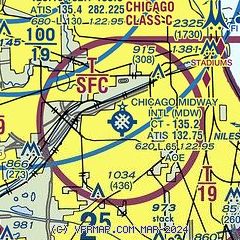
| Sectional chart |
|---|
|
CAUTION: Diagram may not be current
 Download PDF
of official airport diagram from the FAA
| Airport distance calculator |
|---|
|
|
| Sunrise and sunset |
|---|
|
Times for 23-Apr-2024
| | Local
(UTC-5) | | Zulu
(UTC) |
|---|
| Morning civil twilight | | 05:28 | | 10:28 |
| Sunrise | | 05:58 | | 10:58 |
| Sunset | | 19:40 | | 00:40 |
| Evening civil twilight | | 20:10 | | 01:10 |
|
| Current date and time |
|---|
| Zulu (UTC) | 23-Apr-2024 23:12:38 |
|---|
| Local (UTC-5) | 23-Apr-2024 18:12:38 |
|---|
|
| METAR |
|---|
| KMDW | 232253Z 20018G28KT 10SM FEW065 SCT100 SCT130 16/09 A2977 RMK AO2 PK WND 21028/2252 RAE2155 TSE09 SLP079 CB DSNT N-SE P0000 T01610089 $
|
KORD
14nm NW | 232251Z 21012G21KT 10SM FEW070 BKN100 BKN120 16/09 A2974 RMK AO2 PK WND 20026/2234 SLP071 T01610094
|
KIGQ
18nm SE | 232255Z AUTO 20007KT 10SM -RA SCT019 OVC075 13/11 A2983 RMK AO2 T01250113
|
KGYY
18nm SE | 232245Z 20012G25KT 10SM FEW010 FEW043 SCT070 13/13 A2980
|
KLOT
19nm SW | 232245Z 19018G25KT 10SM SCT021 15/13 A2980
|
K06C
20nm NW | 232255Z AUTO 23007KT 10SM BKN100 OVC110 17/10 A2975 RMK AO2 T01650100
|
|
| TAF |
|---|
| KMDW | 232228Z 2322/2424 23014G24KT P6SM VCSH SCT035 BKN080 FM240100 30012G22KT P6SM BKN100 FM240500 02014G24KT P6SM SCT030 FM240700 01013G23KT P6SM BKN025 FM241600 01012G20KT P6SM SCT035
|
KORD
14nm NW | 232220Z 2322/2424 23014G24KT P6SM VCSH SCT035 BKN080 FM240000 30012G22KT P6SM BKN100 FM240400 02014G24KT P6SM SCT030 FM240600 02013G23KT P6SM BKN025 FM241500 01012G20KT P6SM SCT035
|
KGYY
18nm SE | 232207Z 2322/2418 22012G18KT P6SM VCSH BKN060 TEMPO 2322/2401 30015G25KT 3SM -TSRA BKN015CB FM240200 27008KT P6SM SCT100 FM240500 01015G25KT P6SM SCT025 FM240700 36015G22KT P6SM BKN020 FM241700 36015G22KT P6SM SCT035
|
|
| NOTAMs |
|---|
NOTAMs are issued by the DoD/FAA and will open in a separate window not controlled by AirNav.
|
|


