FAA INFORMATION EFFECTIVE 18 APRIL 2024
Location
| FAA Identifier: | ORE |
| Lat/Long: | 42-34-11.9910N 072-17-18.5920W
42-34.199850N 072-17.309867W
42.5699975,-72.2884978
(estimated) |
| Elevation: | 555.6 ft. / 169.3 m (surveyed) |
| Variation: | 15W (2005) |
| From city: | 1 mile SE of ORANGE, MA |
| Time zone: | UTC -4 (UTC -5 during Standard Time) |
| Zip code: | 01364 |
Airport Operations
| Airport use: | Open to the public |
| Activation date: | 04/1940 |
| Control tower: | no |
| ARTCC: | BOSTON CENTER |
| FSS: | BRIDGEPORT FLIGHT SERVICE STATION |
| NOTAMs facility: | ORE (NOTAM-D service available) |
| Attendance: | 0800-1700 |
| Wind indicator: | yes |
| Segmented circle: | yes |
| Lights: | DUSK-DAWN. ACTVT MIRL RWYS 01/19 & 14/32 - CTAF. PAPI RWY 01 OPR CONSLY. |
| Beacon: | white-green (lighted land airport)
Operates sunset to sunrise. |
Airport Communications
| CTAF/UNICOM: | 122.8 |
| WX ASOS: | 135.675 (978-544-6774) |
| WX ASOS at AFN (19 nm NE): | 135.875 (603-532-6195) |
| WX AWOS-3PT at EEN (20 nm N): | 119.025 (603-358-6424) |
- APCH/DEP SVC PRVDD BY BOSTON ARTCC ON FREQS 123.75/338.2 (GARDNER RCAG).
- CLNC DEL THRU BRIDGEPORT RADIO (BDR) 1-866-293-5149.
Nearby radio navigation aids
| VOR radial/distance | | VOR name | | Freq | | Var |
|---|
| GDMr292/10.3 | | GARDNER VOR/DME | | 116.95 | | 14W |
| BAFr052/31.0 | | BARNES VORTAC | | 113.00 | | 14W |
| CTRr073/33.7 | | CHESTER VOR/DME | | 115.10 | | 13W |
Airport Services
| Fuel available: | 100LL JET-A
100LL:100LL FUEL SELF-SVC AVBL 24 HRS. AFT HRS EMERG/FUEL PHONE CTC 978-894-3264. |
| Parking: | tiedowns |
| Airframe service: | MAJOR |
| Powerplant service: | MAJOR |
| Bottled oxygen: | NONE |
| Bulk oxygen: | NONE |
Runway Information
Runway 1/19
| Dimensions: | 5001 x 75 ft. / 1524 x 23 m |
| Surface: | asphalt, in excellent condition |
| Weight bearing capacity: | |
| Runway edge lights: | medium intensity |
| RUNWAY 1 | | RUNWAY 19 |
| Latitude: | 42-33.674042N | | 42-34.497328N |
| Longitude: | 072-17.417928W | | 072-17.406358W |
| Elevation: | 555.6 ft. | | 533.9 ft. |
| Traffic pattern: | left | | left |
| Runway heading: | 016 magnetic, 001 true | | 196 magnetic, 181 true |
| Displaced threshold: | 101 ft. | | 800 ft. |
| Markings: | basic, in good condition | | basic, in good condition |
| Visual slope indicator: | 4-light PAPI on left (3.40 degrees glide path) | | |
| Runway end identifier lights: | no | | no |
| Touchdown point: | yes, no lights | | yes, no lights |
| Obstructions: | 50 ft. trees, 1200 ft. from runway, 125 ft. right of centerline, 20:1 slope to clear | | 30 ft. trees, 800 ft. from runway, 135 ft. right of centerline, 20:1 slope to clear |
Runway 14/32
| Dimensions: | 4800 x 75 ft. / 1463 x 23 m |
| Surface: | asphalt, in good condition |
| Weight bearing capacity: | |
| Runway edge lights: | medium intensity |
| RUNWAY 14 | | RUNWAY 32 |
| Latitude: | 42-34.557135N | | 42-34.080433N |
| Longitude: | 072-17.629715W | | 072-16.776947W |
| Elevation: | 533.3 ft. | | 551.5 ft. |
| Traffic pattern: | left | | left |
| Runway heading: | 142 magnetic, 127 true | | 322 magnetic, 307 true |
| Displaced threshold: | no | | 1290 ft. |
| Markings: | nonprecision, in fair condition | | nonprecision, in fair condition |
| Runway end identifier lights: | no | | no |
| Touchdown point: | yes, no lights | | yes, no lights |
| Obstructions: | 20 ft. trees, 700 ft. from runway, 130 ft. right of centerline, 25:1 slope to clear | | 20 ft. trees, 900 ft. from runway, 125 ft. right of centerline, 34:1 slope to clear |
Airport Ownership and Management from official FAA records
| Ownership: | Publicly-owned |
| Owner: | TOWN OF ORANGE
6 PROSPECT ST
ORANGE, MA 01364
Phone 978-544-1100 |
| Manager: | LEONARD BEDAW
80 AIRPORT ST
ORANGE, MA 01364
Phone 978-544-8189 |
Airport Operational Statistics
| Aircraft based on the field: | | 49 | | Single engine airplanes: | | 46 | | Multi engine airplanes: | | 2 | | Ultralights: | | 1 |
| |  | |
| Aircraft operations: avg 95/day * | | 45% | transient general aviation | | 30% | air taxi | | 25% | local general aviation | | <1% | military | | * for 12-month period ending 15 August 2016 | |
Additional Remarks
| - | PAJA WI 2 NM OF AIRFIELD, SFC TO 14500 FT MSL, 7 DAYS A WEEK, SR-SS, APR 1-NOV 30. |
| - | WILDLIFE ON & INVOF ARPT. |
| - | FOR CD CTC BOSTON ARTCC AT 603-879-6859. |
| - | AFT HRS EMERG/FUEL PHONE CTC 413-348-3654. |
Instrument Procedures
NOTE: All procedures below are presented as PDF files. If you need a reader for these files, you should download the free Adobe Reader.NOT FOR NAVIGATION. Please procure official charts for flight.
FAA instrument procedures published for use from 18 April 2024 at 0901Z to 16 May 2024 at 0900Z.
IAPs - Instrument Approach Procedures |
|---|
| RNAV (GPS) RWY 32 **CHANGED** | |
download (323KB) |
| VOR-A | |
download (210KB) |
| NOTE: Special Alternate Minimums apply | |
download (129KB) |
| NOTE: Special Take-Off Minimums/Departure Procedures apply | |
download (178KB) |
Other nearby airports with instrument procedures:
0B5 - Turners Falls Airport (10 nm W)
KGDM - Gardner Municipal Airport (12 nm E)
KAFN - Jaffrey Airfield Silver Ranch (19 nm NE)
KEEN - Dillant/Hopkins Airport (20 nm N)
7B2 - Northampton Airport (20 nm SW)
|
|

Road maps at:
MapQuest
Bing
Google
| Aerial photo |
|---|
WARNING: Photo may not be current or correct
 Photo by Langford Davidson
Photo taken 05-Jun-2013
looking west.
Photo by Langford Davidson
Photo taken 05-Jun-2013
looking west.
Do you have a better or more recent aerial photo of Orange Municipal Airport that you would like to share? If so, please send us your photo.
|
| Sectional chart |
|---|
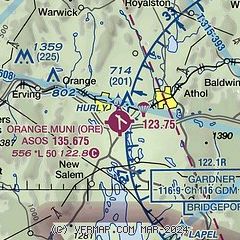
|
| Airport distance calculator |
|---|
|
|
| Sunrise and sunset |
|---|
|
Times for 19-Apr-2024
| | Local
(UTC-4) | | Zulu
(UTC) |
|---|
| Morning civil twilight | | 05:31 | | 09:31 |
| Sunrise | | 06:01 | | 10:01 |
| Sunset | | 19:35 | | 23:35 |
| Evening civil twilight | | 20:05 | | 00:05 |
|
| Current date and time |
|---|
| Zulu (UTC) | 19-Apr-2024 04:53:14 |
|---|
| Local (UTC-4) | 19-Apr-2024 00:53:14 |
|---|
|
| METAR |
|---|
| KORE | 190352Z AUTO 00000KT 10SM OVC041 06/04 A3020 RMK AO2 SLP230 T00610039
|
KAFN
19nm NE | 190430Z AUTO 00000KT 10SM FEW003 OVC037 06/03 A3018 RMK AO2 T00560033
|
KEEN
19nm N | 190356Z AUTO 00000KT 10SM OVC041 06/05 A3019 RMK AO2 RAB06E48 SLP232 P0001 T00560050 $
|
|
| TAF |
|---|
KCEF
24nm SW | 190008Z 1900/2006 03006KT 9999 FEW015 BKN040 OVC070 620802 QNH3016INS TEMPO 1911/1913 10005KT BKN015 BECMG 1912/1913 11006KT 9999 FEW030 BKN040 BKN220 QNH3001INS WND 17012KT AFT 1915 TEMPO 1919/1923 17012G21KT SCT040 BKN150 510004 BECMG 2000/2001 18010KT 9000 -RA FEW010 BKN025 OVC050 620854 510104 QNH3000INS BECMG 2002/2003 18006KT 9000 -RA FEW007 BKN010 OVC020 620705 510053 QNH2996INS TX14/1917Z TN04/1910Z LAST NO AMDS AFT 1903 NEXT 1912
|
KORH
26nm SE | 181721Z 1818/1918 08008KT P6SM -SHRA OVC040 FM190100 08004KT P6SM OVC050 FM191300 11007KT P6SM BKN070
|
|
| NOTAMs |
|---|
NOTAMs are issued by the DoD/FAA and will open in a separate window not controlled by AirNav.
|
|

