FAA INFORMATION EFFECTIVE 18 APRIL 2024
Location
| FAA Identifier: | L18 |
| Lat/Long: | 33-21-15.0000N 117-15-03.0000W
33-21.250000N 117-15.050000W
33.3541667,-117.2508333
(estimated) |
| Elevation: | 708 ft. / 216 m (estimated) |
| Variation: | 13E (1985) |
| From city: | 2 miles S of FALLBROOK, CA |
| Time zone: | UTC -7 (UTC -8 during Standard Time) |
| Zip code: | 92028 |
Airport Operations
| Airport use: | Open to the public |
| Activation date: | 11/1964 |
| Control tower: | no |
| ARTCC: | LOS ANGELES CENTER |
| FSS: | SAN DIEGO FLIGHT SERVICE STATION |
| NOTAMs facility: | L18 (NOTAM-D service available) |
| Attendance: | MON-FRI 0900-1400 |
| Pattern altitude: | TPA - 1708(1000) FIXED WING, 1200(492) HEL. |
| Wind indicator: | yes |
| Segmented circle: | yes |
| Lights: | MIRL RWY 18/36 MED INTST ONLY AVBL. ACTVT MIRL RWY 18/36 & TWY LGTS - CTAF (5 CLICKS ON). |
| Beacon: | white-green (lighted land airport)
Operates sunset to sunrise. |
Airport Communications
| CTAF: | 123.05 |
| WX AWOS-3P: | 118.425 (760-723-6073) |
| SOCAL APPROACH: | 127.3 |
| SOCAL DEPARTURE: | 127.3 |
| CLASS B: | 127.3 ;294-332 SAN BLW 7,000 FT |
| WX ASOS at OKB (10 nm SW): | 127.8 (760-439-9683) |
| WX ASOS at CRQ (14 nm S): | PHONE 760-930-0864 |
| WX AWOS-3 at F70 (15 nm NE): | 119.025 (951-696-1018) |
Nearby radio navigation aids
| VOR radial/distance | | VOR name | | Freq | | Var |
|---|
| OCNr036/10.8 | | OCEANSIDE VORTAC | | 115.30 | | 15E |
| HDFr173/(25.5) | | HOMELAND VOR | | 112.05 | | 14E |
| ELBr115/30.8 | | EL TORO VOR/DME | | 117.20 | | 14E |
| MZBr343/34.3 | | MISSION BAY VORTAC | | 117.80 | | 15E |
| JLIr276/35.7 | | JULIAN VORTAC | | 114.00 | | 15E |
| PDZr143/36.6 | | PARADISE VORTAC | | 112.20 | | 15E |
| RALr151/(37.4) | | RIVERSIDE VOR | | 108.60 | | 14E |
Airport Services
| Fuel available: | 100LL
100LL:SELF-SERVICE FUEL AVBL 24 HRS. |
| Parking: | tiedowns |
| Airframe service: | MAJOR |
| Powerplant service: | MAJOR |
| Bottled oxygen: | HIGH/LOW |
| Bulk oxygen: | NONE |
Runway Information
Runway 18/36
| Dimensions: | 2160 x 60 ft. / 658 x 18 m |
| Surface: | asphalt/rubberized friction seal coat, in good condition |
| Weight bearing capacity: | |
| Runway edge lights: | medium intensity |
| RUNWAY 18 | | RUNWAY 36 |
| Latitude: | 33-21.422667N | | 33-21.077333N |
| Longitude: | 117-14.998167W | | 117-15.101833W |
| Elevation: | 708.0 ft. | | 699.0 ft. |
| Traffic pattern: | left | | right |
| Runway heading: | 181 magnetic, 194 true | | 001 magnetic, 014 true |
| Markings: | basic, in good condition | | basic, in good condition |
| Visual slope indicator: | pulsating/steady burning VASI on left (4.00 degrees glide path) | | |
| Runway end identifier lights: | no | | no |
| Touchdown point: | yes, no lights | | yes, no lights |
Helipad H1
| Dimensions: | 45 x 45 ft. / 14 x 14 m |
| Surface: | asphalt/concrete, in good condition |
| Operational restrictions: | RSTD TO PUBLIC SAFETY ACFT. |
| Latitude: | 33-21.112167N | | |
| Longitude: | 117-15.024667W | | |
| Elevation: | 697.0 ft. | | |
| Traffic pattern: | left | | left |
Airport Ownership and Management from official FAA records
| Ownership: | Publicly-owned |
| Owner: | COUNTY OF SAN DIEGO
1960 JOE CROSSON DRIVE
EL CAJON, CA 92020-1235
Phone 619-956-4800 |
| Manager: | MEADOW CHASE
2155 SOUTH MISSION ROAD
FALLBROOK, CA 92028
Phone 760-723-8395 |
Airport Operational Statistics
| Aircraft based on the field: | | 98 | | Single engine airplanes: | | 95 | | Multi engine airplanes: | | 2 | | Gliders airplanes: | | 1 |
| |  | |
| Aircraft operations: avg 58/day * | | 65% | local general aviation | | 35% | transient general aviation | | * for 12-month period ending 31 December 2020 | |
Additional Remarks
| - | NO SAFETY AREA AVBL DUE TO ABRUPT DROP-OFF EACH END OF RWY. |
| - | CONC HELIPAD CLOSED TO UNAUTHORIZED AIRCRAFT. |
| - | AP ADMIN BLDG EAST SIDE OF RWY; FUELING AREA WEST OF AFLD. |
| - | PART 77 OBSTRUCTION, +15 FT HILL 100 FT E OF RWY 18 CNTRLN. |
| - | ROTORCRAFT FUEL UNAVBL. RCMDD HEL TFC PAT APCH AND DEP AT 492 FT AGL TO AND FROM EAST AT MID RWY. HEL TGL RSTRD TO RWY. |
| - | HOVERS, SKID LANDINGS, AND AUTO-ROTATIONS PROHIBITED. |
| - | RWY 18 CALM WIND RWY |
| - | TRAN PRKG LCTD ON SE CORNER OF AFLD. |
| - | OCNL COYOTE ON OR IN THE VICINITY OF RWY AND TWY. |
| - | ACFT SHALL SELF-ANNOUNCE ON CTAF PRIOR TO LDG OR TKOF. |
| - | FOR CD CTC SOCAL APCH AT 800-448-3724. |
| - | NOISE ABATEMENT: TKOFS CLIMB STRAIGHT AHEAD TO 1200 FT MSL. RWY 18 TURN CROSSWIND WHEN ABEAM WATER TANK 1.1 MI ESE OF RWY. RWY 18 EXTEND DOWNWIND LEG TO ALLOW 1/3 MILE FINAL APCH. FLY DOWNWIND EAST OF HIGH SCHOOL. |
| - | PPR FOR ALL ACFT OVER 12000 LBS AND ALL MIL ACFT, CTC AMGR. |
| - | TWY HOLD BARS NON -STD DIST FM RY EDGE. |
| - | MIL BASE SW, FRQ MIL HELS IN VICINITY OF ARPT. |
Instrument Procedures
NOTE: All procedures below are presented as PDF files. If you need a reader for these files, you should download the free Adobe Reader.NOT FOR NAVIGATION. Please procure official charts for flight.
FAA instrument procedures published for use from 18 April 2024 at 0901Z to 16 May 2024 at 0900Z.
IAPs - Instrument Approach Procedures |
|---|
| GPS RWY 18 | |
download (275KB) |
| NOTE: Special Alternate Minimums apply | |
download (140KB) |
|
|---|
| FALLBROOK ONE (OBSTACLE) | |
download (195KB) |
| NOTE: Special Take-Off Minimums/Departure Procedures apply | |
download (198KB) |
Other nearby airports with instrument procedures:
KNFG - Camp Pendleton MCAS (Munn Field) Airport (6 nm SW)
KOKB - Bob Maxwell Memorial Airfield (10 nm SW)
KCRQ - Mc Clellan-Palomar Airport (14 nm S)
F70 - French Valley Airport (15 nm NE)
KRNM - Ramona Airport (25 nm SE)
|
|

Road maps at:
MapQuest
Bing
Google
| Aerial photo |
|---|
WARNING: Photo may not be current or correct
 Photo courtesy of West Coast Aerial Photography
Photo taken 08-Mar-2017
looking southwest.
Photo courtesy of West Coast Aerial Photography
Photo taken 08-Mar-2017
looking southwest.
Do you have a better or more recent aerial photo of Fallbrook Community Airpark that you would like to share? If so, please send us your photo.
|
| Sectional chart |
|---|
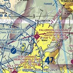
|
| Airport distance calculator |
|---|
|
|
| Sunrise and sunset |
|---|
|
Times for 19-Apr-2024
| | Local
(UTC-7) | | Zulu
(UTC) |
|---|
| Morning civil twilight | | 05:48 | | 12:48 |
| Sunrise | | 06:14 | | 13:14 |
| Sunset | | 19:22 | | 02:22 |
| Evening civil twilight | | 19:48 | | 02:48 |
|
| Current date and time |
|---|
| Zulu (UTC) | 19-Apr-2024 13:42:04 |
|---|
| Local (UTC-7) | 19-Apr-2024 06:42:04 |
|---|
|
| METAR |
|---|
| KL18 | 191315Z AUTO 10SM OVC007 12/11 A2996 RMK AO2
|
KNFG
6nm SW | 191255Z AUTO 00000KT 10SM OVC013 15/12 A2995 RMK AO2 SLP142 T01500117
|
KOKB
10nm SW | 191252Z AUTO 34003KT 7SM OVC015 15/12 A2994 RMK AO2 SLP139 T01500122
|
KNXF
11nm W | 191153Z AUTO 00000KT 10SM OVC017 14/12 A2994 RMK AO2 SLP225 T01440122 10150 20144 56010 $
|
KCRQ
13nm S | 191253Z AUTO 00000KT 10SM OVC020 14/09 A2994 RMK AO2 SLP136 T01440094
|
KF70
15nm NE | 191315Z AUTO 00000KT 5SM BR OVC004 12/12 A2996 RMK AO2
|
|
| TAF |
|---|
KNFG
6nm SW | 1909/2009 VRB05KT 9999 OVC014 QNH2994INS BECMG 1918/1920 24008KT FEW010 OVC030 QNH2991INS BECMG 1923/2001 VRB05KT QNH2992INS FM200330 VRB05KT 9999 OVC015 QNH2994INS T14/1913Z T19/1921Z
|
KCRQ
13nm S | 191125Z 1912/2012 VRB03KT P6SM OVC018 FM191500 VRB03KT P6SM OVC022 FM191800 25008KT P6SM SCT022 TEMPO 1923/2003 BKN022 FM200300 VRB04KT P6SM OVC022
|
|
| NOTAMs |
|---|
NOTAMs are issued by the DoD/FAA and will open in a separate window not controlled by AirNav.
|
|


