FAA INFORMATION EFFECTIVE 18 APRIL 2024
Location
| FAA Identifier: | M86 |
| Lat/Long: | 42-28-15.5000N 086-07-32.3000W
42-28.258333N 086-07.538333W
42.4709722,-86.1256389
(estimated) |
| Elevation: | 635 ft. / 194 m (estimated) |
| Variation: | 03W (1985) |
| From city: | 2 miles SW of PULLMAN, MI |
| Time zone: | UTC -4 (UTC -5 during Standard Time) |
| Zip code: | 49450 |
Airport Operations
| Airport use: | Open to the public |
| Activation date: | 10/1990 |
| Control tower: | no |
| ARTCC: | CHICAGO CENTER |
| FSS: | LANSING FLIGHT SERVICE STATION |
| NOTAMs facility: | LAN (NOTAM-D service available) |
| Attendance: | UNATNDD |
| Wind indicator: | no |
| Segmented circle: | no |
Airport Communications
| CTAF: | 122.9 |
| WX AWOS-3 at LWA (9 nm SW): | 118.025 (269-637-7016) |
| WX ASOS at BIV (16 nm N): | 119.025 (616-394-0190) |
Nearby radio navigation aids
| VOR radial/distance | | VOR name | | Freq | | Var |
|---|
| PMM at field | | PULLMAN VOR/DME | | 112.10 | | 00E |
| ELXr360/19.6 | | KEELER VOR/DME | | 116.60 | | 00E |
| VIOr240/33.6 | | VICTORY VOR/DME | | 115.95 | | 04W |
Airport Services
Runway Information
Runway 9/27
| Dimensions: | 1699 x 60 ft. / 518 x 18 m |
| Surface: | turf, in poor condition
ROUGH SFC WITH SOFT AREAS, STANDING WATER, & DIRT PILES. RY SOFT IN SPRING & WHEN WET. |
| Runway edge markings: | RY 09/27 DSPLCD THLDS MKD WITH THREE, 3 FT YELLOW CONES EACH SIDE OF RY; RY DEFINED BY MOWING. |
| RUNWAY 9 | | RUNWAY 27 |
| Latitude: | 42-28.258333N | | 42-28.258333N |
| Longitude: | 086-07.728000W | | 086-07.350000W |
| Elevation: | 640.0 ft. | | 640.0 ft. |
| Traffic pattern: | left | | left |
| Obstructions: | 15 ft. road, 15 ft. from runway, 1:1 slope to clear
APCH RATIO 20:1 AT DSPLCD THLD, 47 FT TREES, 958 FT DSTC, 0B. | | 37 ft. trees, 258 ft. from runway, 6:1 slope to clear
APCH RATIO 0:1 AT DSPLCD THLD +60 FT TREES 0 FT DSTC, 130 FT L. APCH RATION 14:1 BASED ON 52 FT TREES, 768 FT. DSTC. ALSO, 50 FT TREES, 0 FT DSTC, 130 FT L/R EAST HALF OF RY. |
Airport Ownership and Management from official FAA records
| Ownership: | Privately-owned |
| Owner: | ED WALLE
6025 107 AV
PULLMAN, MI 49450
Phone 269-214-6898 |
| Manager: | ED WALLE
6025 107 AV
PULLMAN, MI 49450
Phone 269-214-6898 |
Additional Remarks
| - | DEER & ANIMALS ON & INVOF ARPT. |
| - | 60 FT TREES, 130 FT BOTH SIDES OF RY CENTERLINE. |
| - | FOR CD CTC GREAT LAKES APCH AT 269-459-3344, WHEN APCH CLSD CTC CHICAGO ARTCC AT 630-906-8921. |
Instrument Procedures
There are no published instrument procedures at M86.
Some nearby airports with instrument procedures:
KLWA - South Haven Area Regional Airport (9 nm SW)
35D - Padgham Field Airport (14 nm E)
KBIV - West Michigan Regional Airport (16 nm N)
KBEH - Southwest Michigan Regional Airport (24 nm SW)
C91 - Dowagiac Municipal Airport (29 nm S)
|
|

Road maps at:
MapQuest
Bing
Google
| Aerial photo |
|---|
WARNING: Photo may not be current or correct
 Photo by Roy Carlson, Plainwell MI
Photo taken 16-Oct-2005
Photo by Roy Carlson, Plainwell MI
Photo taken 16-Oct-2005
Do you have a better or more recent aerial photo of Walle Field Airport that you would like to share? If so, please send us your photo.
|
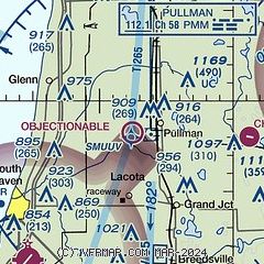
| Sectional chart |
|---|
|
| Airport distance calculator |
|---|
|
|
| Sunrise and sunset |
|---|
|
Times for 20-Apr-2024
| | Local
(UTC-4) | | Zulu
(UTC) |
|---|
| Morning civil twilight | | 06:25 | | 10:25 |
| Sunrise | | 06:55 | | 10:55 |
| Sunset | | 20:32 | | 00:32 |
| Evening civil twilight | | 21:01 | | 01:01 |
|
| Current date and time |
|---|
| Zulu (UTC) | 20-Apr-2024 04:29:21 |
|---|
| Local (UTC-4) | 20-Apr-2024 00:29:21 |
|---|
|
| METAR |
|---|
KLWA
9nm SW | 200415Z AUTO 28011G20KT 10SM BKN080 08/M01 A3008 RMK AO2 T00751012
|
KBIV
17nm N | 200353Z AUTO 32013G25KT 10SM FEW090 07/M03 A3006 RMK AO2 PK WND 29033/0323 SLP181 T00671028
|
|
| TAF |
|---|
KAZO
29nm SE | 191730Z 1918/2018 27015G26KT P6SM FEW200 FM200100 27011KT P6SM FEW060
|
KGRR
37nm NE | 191730Z 1918/2018 27018G28KT P6SM FEW060 FM200100 27011KT P6SM SCT060
|
|
| NOTAMs |
|---|
NOTAMs are issued by the DoD/FAA and will open in a separate window not controlled by AirNav.
|
|

